- Home
- :
- All Communities
- :
- Products
- :
- Geoprocessing
- :
- Geoprocessing Questions
- :
- Re: How to create a polygon based on points with t...
- Subscribe to RSS Feed
- Mark Topic as New
- Mark Topic as Read
- Float this Topic for Current User
- Bookmark
- Subscribe
- Mute
- Printer Friendly Page
How to create a polygon based on points with the same attribute
- Mark as New
- Bookmark
- Subscribe
- Mute
- Subscribe to RSS Feed
- Permalink
Hey,
I have a points feature class, and it consists of features that all have a unique name, but also a 'site name'. So dozens of points, can have identical site names.
I would like to create a polygon around each 'group' of points with the same attribute. For example, all points with the attribute 'Green', then all with attribute of 'Red', then all with attribute 'Orange'.
note these points can be co-mingled, so the polygons will be overlapping. The end goal is to create a data driven page set to print all 'like' points.
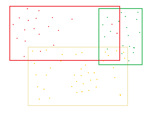
here is a very accurate and 'to scale' outline of what I want... I want the three polygons to be created automatically.
Is anyone able to tell me the steps I need to take to create these polygons automatically?
Solved! Go to Solution.
Accepted Solutions
- Mark as New
- Bookmark
- Subscribe
- Mute
- Subscribe to RSS Feed
- Permalink
it has been so long since I have looked at my Bounding Containers but, I am pretty sure you can group your points by an attribute, then you want to return the 'extent polygon' for each of the groupings
- Mark as New
- Bookmark
- Subscribe
- Mute
- Subscribe to RSS Feed
- Permalink
it has been so long since I have looked at my Bounding Containers but, I am pretty sure you can group your points by an attribute, then you want to return the 'extent polygon' for each of the groupings
- Mark as New
- Bookmark
- Subscribe
- Mute
- Subscribe to RSS Feed
- Permalink
Thanks for sharing that toolbox Dan, it was 99% of my solution, I just had to tweak the code as it kept crashing as I was using a File GDB and my field names were > 10 characters long, so in the Python I just had it trim the field names back and now it works a treat.
Thanks again.
- Mark as New
- Bookmark
- Subscribe
- Mute
- Subscribe to RSS Feed
- Permalink
good... yeah. I have to update that to use *.gdb featureclasses, but I work outside Arc* so much, I haven't found the need (...yet...)
- Mark as New
- Bookmark
- Subscribe
- Mute
- Subscribe to RSS Feed
- Permalink
Ben:
Use the buffer tool on your points to give the minimum space around any given point nearest to the ultimate rectangle edge as a temporary fc, then apply the Minimum Bounding Rectangle to the buffer output with the Envelope Option. It will be as precise as your drawing. The Buffer tool can group the point buffer output into a single multipart object for each unique value in a field or fields using the List option and the field list parameters. See the help here: Buffer. In the same way the Minimum Bounding Rectangle tool can also respect the unique value groupings from one or more fields using the List option and the field list. See the help here: Minimum Bounding Rectangle.