- Home
- :
- All Communities
- :
- Products
- :
- Geoprocessing
- :
- Geoprocessing Questions
- :
- Re: Generate Tessellation Pro 2.0 not creating req...
- Subscribe to RSS Feed
- Mark Topic as New
- Mark Topic as Read
- Float this Topic for Current User
- Bookmark
- Subscribe
- Mute
- Printer Friendly Page
Generate Tessellation Pro 2.0 not creating requested size of hexagons
- Mark as New
- Bookmark
- Subscribe
- Mute
- Subscribe to RSS Feed
- Permalink
I'm having trouble with the Generate Tessellation GP tool in Pro 2.0. I can't get it to create the correct sized polygons.
PROCESS
I created a new Pro project and added our County boundary polygon, in State Plane, feet. I verified that the Map Frame coordinate system is in feet.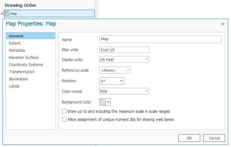
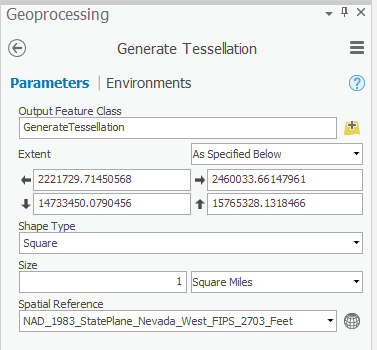
I generated a tessellation using the extent of the County boundary and specifying a size of 1 square mile.
OUTPUT
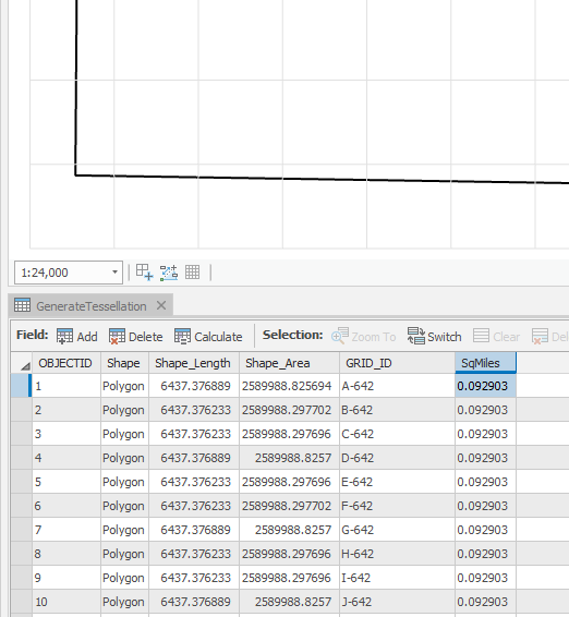
The output is NOT a set of polygons with area=1 sq mile, but rather area= 0.092903 sq miles (2589988.8 sq feet). This is the consistent area of the polygons in the result whether I generate square or hex polygons.
Any ideas?
Jay
- Mark as New
- Bookmark
- Subscribe
- Mute
- Subscribe to RSS Feed
- Permalink
Did you do that in an empty map?
I just did all 3, square, hex and triangle using a file of known extent with a projected coordinate, to specify the extent... I got the correct area for each geometry type. The only thing I don't like is that the features dribble beyond the extent and are not clipped at the desired bounds necessitating further processing
Addendum
The only difference is that my extent, map and reference layer are metric, not imperial
- Mark as New
- Bookmark
- Subscribe
- Mute
- Subscribe to RSS Feed
- Permalink
Thanks Dan, useful to know that it does work for someone else.
Not in an empty map, no.
I started with a new project, added a map frame, added a projected county boundary and verified that my map coordinate system matched my county boundary coordinate system (NV State Plane, feet).
I guess I can grab a metric layer and try everything in metric...
- Mark as New
- Bookmark
- Subscribe
- Mute
- Subscribe to RSS Feed
- Permalink
This is when I begin to wonder if feet is really meters or meters is really feet... a small misdefine makes the difference and can be hard to verify unless the data are from a known source that preferably only publishes in one unit
- Mark as New
- Bookmark
- Subscribe
- Mute
- Subscribe to RSS Feed
- Permalink
Basically, me too... Followed Jay's procedures almost exactly and had the same exact result. Only difference is that I am in California State Plane. Thought I would try the geoprocessing tool in ArcMap instead of Pro, but, it also produces the same smaller area (1 sq mile outputs as 0.092903 sq miles).
Switching the data frame and output spatial reference to NAD_1983_UTM_Zone_10N (meters) and using 2.58999 Square Kilometers I was able to get my hexagons to come in at 1 sq mile.
- Mark as New
- Bookmark
- Subscribe
- Mute
- Subscribe to RSS Feed
- Permalink
revitalized for PRO 2.1 www.arcgis.com/home/item.html?id=ddb2deec9b5e4a09affe60de68f5ff4e
- Mark as New
- Bookmark
- Subscribe
- Mute
- Subscribe to RSS Feed
- Permalink
Over two years later, using ArcPro Version 2.1.2 encountering the same error within the build of the Generate Tessellation tool. This is a big error to ignore for so long. Where can I file a formal request for ESRI to fix this error?