- Home
- :
- All Communities
- :
- Products
- :
- Geoprocessing
- :
- Geoprocessing Questions
- :
- Re: From Point to Gird, fishnet does not work
- Subscribe to RSS Feed
- Mark Topic as New
- Mark Topic as Read
- Float this Topic for Current User
- Bookmark
- Subscribe
- Mute
- Printer Friendly Page
From Point to Gird, fishnet does not work
- Mark as New
- Bookmark
- Subscribe
- Mute
- Subscribe to RSS Feed
- Permalink
Dear all,
I am done; I have spent half the day trying to figure out how how to get my point data to grid data. The data I use give information on sedimentary thickness for the entire world. However, the dataset is in point form. To merge it with other data (point data) I want to turn it into a grid.
I tried Fishnet but stating the number of rows and columns does not work, because the cells take such forms that the original points do not lie in the middle any longer. Stating the size of the cells also does not work, because Fishnet wants it in meters, but the original data gives the information in decimal degrees.
I also tried Grid Index Features. That seemed to work nicely, as I can state the size in dec. degrees. However, the original points are now at the corners of the cells and not in the middle where they belong.
I have attached the file with the data.
Please help me with this problem. It can't be that difficult but it is driving me to despair.
Thanks a lot, folks.
- Mark as New
- Bookmark
- Subscribe
- Mute
- Subscribe to RSS Feed
- Permalink
Try setting the origin coordinate in Grid Index Features.
- Mark as New
- Bookmark
- Subscribe
- Mute
- Subscribe to RSS Feed
- Permalink
You could do the following.
1. Add the Point Feature Class (FC) in a blank MXD.
2. Using the Point FC, perform a Point to Raster geoprocessing. Cell_Size=1
3. Perform a Create FishNet using the above Raster as template. See screenshot below for the rest of the parameters.

4. The grids are created as desired.

Think Location
- Mark as New
- Bookmark
- Subscribe
- Mute
- Subscribe to RSS Feed
- Permalink
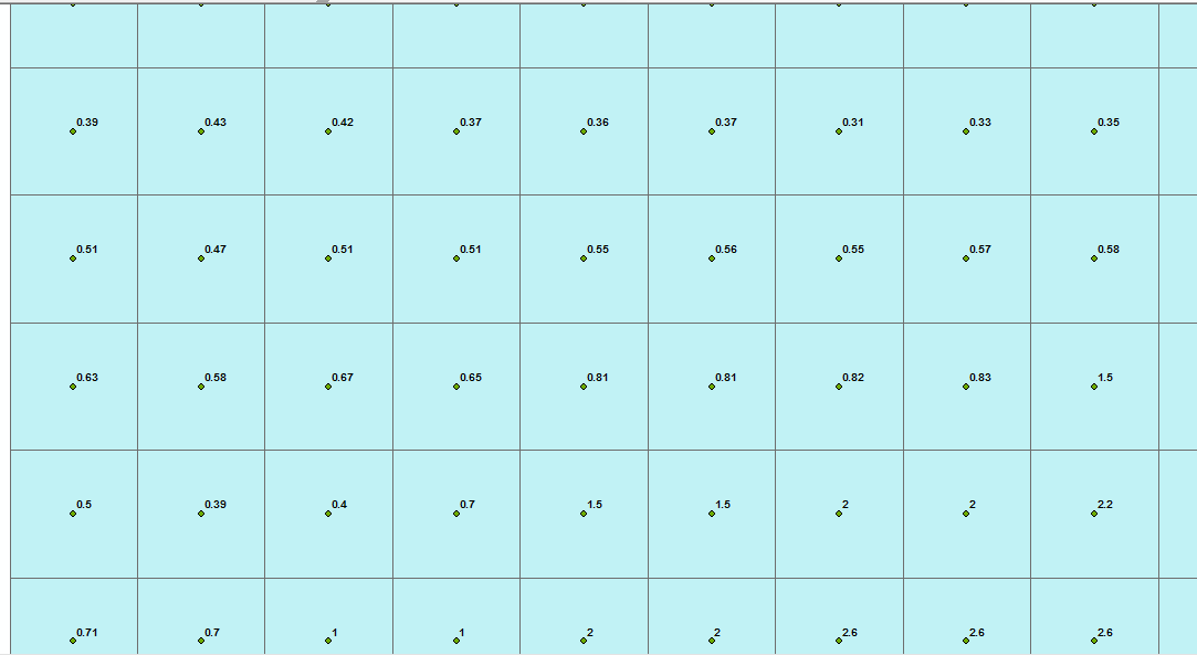
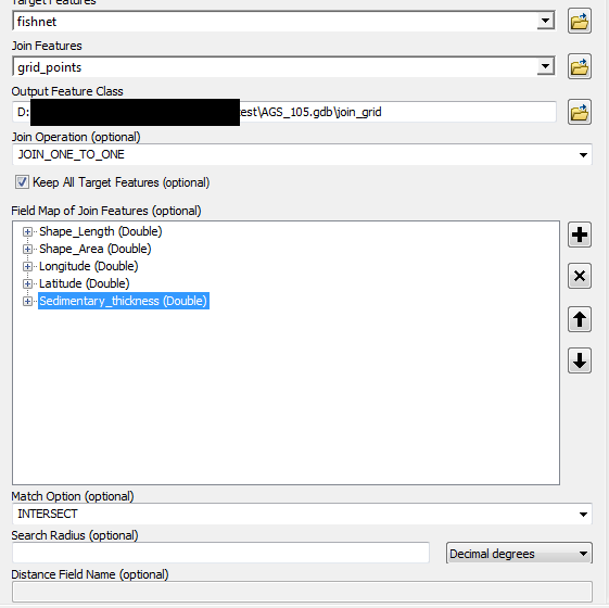
Thanks a lot! Tried with setting the origin coordinate in Grid Index Features, changing them by half a decimal degree and it worked like a charm. The resulting grid does not have the information on sedimentary thickness. This should not be a problem; a simple spatial join should work. But for some reason I cannot join the points to the grid.
I have worked with an older ArcGIS version in the past (three years ago) and it worked well. But somehow I cannot make it work here. This is the error I get:
ERROR 999999: Error executing function.
Invalid SQL syntax[near "IN": syntax error]
Failed to execute (SpatialJoin).
Target is the grid
Join Features the points
I use one to one join, keeping all features, merge rule first, and match option intersect
what I don't know what to do with is everything within Output Fields, Source, and Properties
To be honest, I don't recall joining being that complicated in the old days
Any help would be much appreciated once again!
Btw.: I receive the same error when trying to joing my oil fields (points) to the grid with a one to many join.
- Mark as New
- Bookmark
- Subscribe
- Mute
- Subscribe to RSS Feed
- Permalink
everything is in the same coordinate system I presume? and when you mean older version, what version of arcmap are you using or are you using PRO it isn't obvious since you have posted this in GeoNet help... which is about getting help about geonet and not specific to https://community.esri.com/community/gis/analysis/geoprocessing?sr=search&searchId=5dbfe366-b5d0-417... or https://community.esri.com/community/gis/applications/arcgis-pro?sr=search&searchId=7991aac9-1110-4b... or https://community.esri.com/community/gis/managing-data?sr=search&searchId=524ae128-b4c5-4740-9c8a-38... for instance
- Mark as New
- Bookmark
- Subscribe
- Mute
- Subscribe to RSS Feed
- Permalink
I am sorry, as you know I am a complete novice. Let me clarify:
I am using the trial version of ArcGIS Pro. I should also have access to ArcMap, but right now I am just using Pro. As it is the trial version, this should be the latest avaible.
Three years ago was the last time I used ArcGIS. So a) I forgot most of the few things I knew back then and b) the interface looked quite a bit different.
As I created the grid from the point dataset it pretty much has to be the same coordinate system doesn't it? Can I check this somehow?
However, I just noticed something strange: When I click on a point - sedimentary or oilfield - it does not give me any information on that point. It just gives me the variable names, but no values for the variables. It just repeats the varible name where a value should be. So instead of "sedimentary 1.3" it says "sedimentary sedimentary". But when I open the attribute tables of the layers the info is there..
Edit: apparently ArcMap is NOT included in the trial version
- Mark as New
- Bookmark
- Subscribe
- Mute
- Subscribe to RSS Feed
- Permalink
Hi, thanks I just tried that too and it works somehow. I get a very nice image for the raster and I also get a proper fishnet. But I cannot attach the value of the cells in the raster to the fishnet. I also cannot use the raster to join my oilfield data (which is the reason I am doing all this). Can you tell me what I am doing wrong?
- Mark as New
- Bookmark
- Subscribe
- Mute
- Subscribe to RSS Feed
- Permalink
see you other thread
- Mark as New
- Bookmark
- Subscribe
- Mute
- Subscribe to RSS Feed
- Permalink
I am able to do the spatial join without any issue. Moreover, I am not getting the option of Merge Rule in the tool.
using ArcMap 10.5 (Analysis toolbox > Overlay toolset > Spatial Join).
Think Location
- Mark as New
- Bookmark
- Subscribe
- Mute
- Subscribe to RSS Feed
- Permalink
I don't have access to ArcMap at the moment; I hope this will change soon. For the moment I am limited to ArcGIS Pro.
I helped myself with Raster to Polygon, but unfortunately this is not a solution as I need information for each seperate cell.