Turn on suggestions
Auto-suggest helps you quickly narrow down your search results by suggesting possible matches as you type.
Cancel
- Home
- :
- All Communities
- :
- Products
- :
- Geoprocessing
- :
- Geoprocessing Questions
- :
- Failed to launch simple Geoprocessing Webservice
Options
- Subscribe to RSS Feed
- Mark Topic as New
- Mark Topic as Read
- Float this Topic for Current User
- Bookmark
- Subscribe
- Mute
- Printer Friendly Page
Failed to launch simple Geoprocessing Webservice
Subscribe
1265
3
11-05-2012 11:08 AM
by
Anonymous User
Not applicable
11-05-2012
11:08 AM
- Mark as New
- Bookmark
- Subscribe
- Mute
- Subscribe to RSS Feed
- Permalink
Original User: jberumen341873
Greetings everyone,
I am currently trying to develop a custom data extract tool similar to the one used by the Flex Viewer. The difference is that this web service is supposed to output a simple .csv file instead of a geodatabase, shapefile, etc.
[ATTACH=CONFIG]19023[/ATTACH]
I have built this very simple model that clips and converts the resulting features into a CSV file. The model obviously works when executed on the Desktop, but fails on the server.
[ATTACH=CONFIG]19024[/ATTACH]
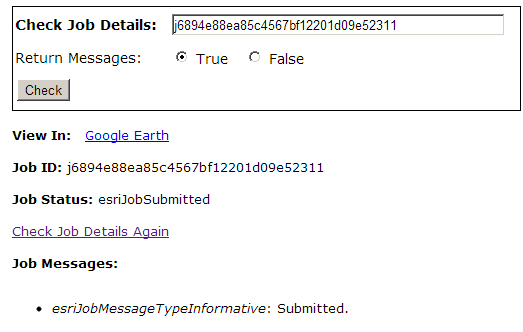
The server returns a JobSubmitted token, so I know the input is formatted properly. However, soon after the server returns failure.
[ATTACH=CONFIG]19025[/ATTACH]
I have been trying to determine the source of the error. I have visited the logs for that job and found this in the documentation:
I am not sure why it gives me an error if I correctly generate a csv file in ArcGIS Desktop.
Does someone have an idea of what is the error? Many thanks for all your help!
Regards,
Jorge
Greetings everyone,
I am currently trying to develop a custom data extract tool similar to the one used by the Flex Viewer. The difference is that this web service is supposed to output a simple .csv file instead of a geodatabase, shapefile, etc.
[ATTACH=CONFIG]19023[/ATTACH]
I have built this very simple model that clips and converts the resulting features into a CSV file. The model obviously works when executed on the Desktop, but fails on the server.
[ATTACH=CONFIG]19024[/ATTACH]
The server returns a JobSubmitted token, so I know the input is formatted properly. However, soon after the server returns failure.
[ATTACH=CONFIG]19025[/ATTACH]
I have been trying to determine the source of the error. I have visited the logs for that job and found this in the documentation:
Server Context created.
String request received. Request size is 277 characters.
GetDefaultMapName has started.
GetDefaultMapName has completed.
String request succesfully processed. Response size is 385 characters.
String request received. Request size is 275 characters.
GetDocumentInfo has started.
GetDocumentInfo has completed.
String request succesfully processed. Response size is 1406 characters.
String request received. Request size is 321 characters.
GetServerInfo has started.
GetServerInfo has completed.
String request succesfully processed. Response size is 23989 characters.
String request received. Request size is 287 characters.
GetServiceConfigurationInfo has started.
GetServiceConfigurationInfo has completed.
String request succesfully processed. Response size is 1281 characters.
String request received. Request size is 542 characters.
GetDefaultLayerDrawingDescriptions has started.
GetDefaultLayerDrawingDescriptions has completed.
String request succesfully processed. Response size is 2465 characters.
String request received. Request size is 341 characters.
GetCacheDescriptionInfo has started.
GetCacheDescriptionInfo has completed.
String request succesfully processed. Response size is 399 characters.
String request received. Request size is 333 characters.
String request succesfully processed. Response size is 391 characters.
Server Context released.
Server Context created.
String request received. Request size is 272 characters.
Container 6048 is successfully created on machine server.
Thread 10828 is successfully created on container 6048 of machine server.
GPServer instance is successfully constructed.
Server Object instance is successfully created on machine server.
Server Context created.
String request received. Request size is 272 characters.
String request succesfully processed. Response size is 11000 characters.
String request received. Request size is 282 characters.
String request succesfully processed. Response size is 431 characters.
String request received. Request size is 276 characters.
String request succesfully processed. Response size is 406 characters.
Server Context released.
Server Context created.
String request received. Request size is 2685 characters.
Job j6894e88ea85c4567bf12201d09e52311 is successfully submitted.
String request succesfully processed. Response size is 396 characters.
Server Context released.
Server Context created.
String request received. Request size is 342 characters.
String request succesfully processed. Response size is 385 characters.
String request received. Request size is 346 characters.
String request succesfully processed. Response size is 550 characters.
Server Context released.
Job j6894e88ea85c4567bf12201d09e52311 scheduled for execution.
Create directory succeeded: c:\arcgisserver\arcgisjobs\gravitymagnetic\gravity_mag_us_webmercator_gpserver\j6894e88ea85c4567bf12201d09e52311\scratch
Load job j6894e88ea85c4567bf12201d09e52311 message type SOAP message size 2685
ERROR 000816: The tool is not valid.
Error executing tool.
Save job j6894e88ea85c4567bf12201d09e52311 message type SOAP message size 371
Server Context released.
Server Context created.
String request received. Request size is 342 characters.
String request succesfully processed. Response size is 382 characters.
String request received. Request size is 346 characters.
String request succesfully processed. Response size is 831 characters.
I am not sure why it gives me an error if I correctly generate a csv file in ArcGIS Desktop.
Does someone have an idea of what is the error? Many thanks for all your help!
Regards,
Jorge
3 Replies
11-05-2012
12:03 PM
- Mark as New
- Bookmark
- Subscribe
- Mute
- Subscribe to RSS Feed
- Permalink
Hello,
First, I'd suggest turning on messages at the service level - that way you'll get more than "Submitted, Executing, Succeed / Fail" for the GP Messages.
The messages you have, they say something about "ERROR 000816: The tool is not valid."
This is problem the message you'll see if you turn messages on.
The question is how/why are you getting this.
Are you using 10 or 10.1?
The USMag variable, its a raster? Can you confirm that Server has access to it?
Do you get the same error when trying to consume your service in desktop?
by
Anonymous User
Not applicable
11-05-2012
01:07 PM
- Mark as New
- Bookmark
- Subscribe
- Mute
- Subscribe to RSS Feed
- Permalink
Original User: jberumen341873
Unfortunately, I get the same errors if I execute it on a remote ArcGIS Desktop instance. Please see the snapshots below with the messages enabled:
[ATTACH=CONFIG]19033[/ATTACH]
ArcGIS Map consuming web service
[ATTACH=CONFIG]19035[/ATTACH]
This is running on server 10 ; not 10.1
The USMag is not a raster, it's a features set of points. Server does have access to it. Thanks.
11-05-2012
01:11 PM
- Mark as New
- Bookmark
- Subscribe
- Mute
- Subscribe to RSS Feed
- Permalink
Ok, my best guess is the USMag is the problem.
If it's actual type is "Feature set", and you don't have it exposed as a parameter, then you arent passing anything in.
I'd suggest either changing it to FeatureClass (and NOT exposed as a parameter) and reference a featureclass, or keeping it as a FeatureSet, but exposing it as a parameter.
And publish this.
(this is just a best guess based on the screen shot of your model)