- Home
- :
- All Communities
- :
- Products
- :
- Geoprocessing
- :
- Geoprocessing Questions
- :
- Distance between start- and end-points
- Subscribe to RSS Feed
- Mark Topic as New
- Mark Topic as Read
- Float this Topic for Current User
- Bookmark
- Subscribe
- Mute
- Printer Friendly Page
- Mark as New
- Bookmark
- Subscribe
- Mute
- Subscribe to RSS Feed
- Permalink
Hi,
How do I measure the distance between the start and end points of a line? So not the length of the line itself, but the straight line distance between the two points?
Thanks,
Mike.
Solved! Go to Solution.
Accepted Solutions
- Mark as New
- Bookmark
- Subscribe
- Mute
- Subscribe to RSS Feed
- Permalink
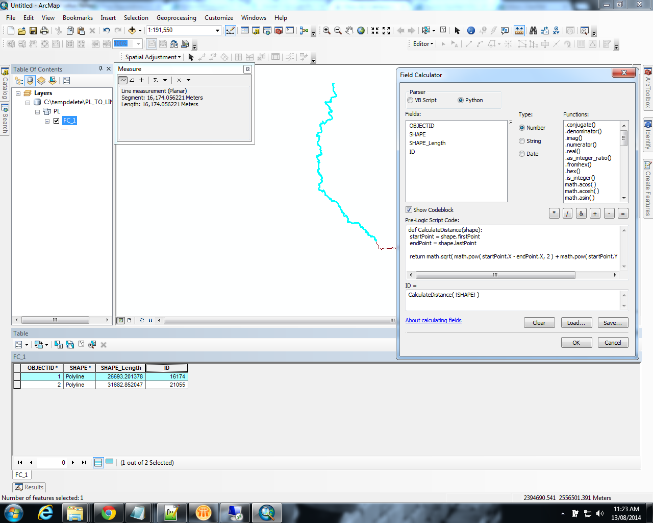
Hi Mike,
Below function lets you calculate the shortest distance between start and end point of a line as an attribute column in arcmap.
def CalculateDistance(shape):
startPoint = shape.firstPoint
endPoint = shape.lastPoint
return math.sqrt( math.pow( startPoint.X - endPoint.X, 2 ) + math.pow( startPoint.Y - endPoint.Y, 2 ))
- Mark as New
- Bookmark
- Subscribe
- Mute
- Subscribe to RSS Feed
- Permalink
If you have the coordinates of the points (P1, P2) then.
d = Math.sqrt(Math.Pow(P1.x - p2.X, 2) + Math.Pow(P1.y - P2.y, 2))
- Mark as New
- Bookmark
- Subscribe
- Mute
- Subscribe to RSS Feed
- Permalink
If you want to calculate this for a line feature class you can follow these steps - not sure if there is a simpler way but it works 
- Make sure you have a unique field that identifies each line, for example copy the object id into a new field called LineID.
- Add the following fields to your data: StartX, StartY, EndX, EndY, LineDist (all double field type)
- Open the attribute table, right-click on the new field headers and use the Calculate Geometry option to populate the fields (X Coordinate of Line Start, Y Coordinate of Line Start, etc)
- From the attribute table Export the data as PointData and add it to the map (this makes the next step easier).
- Go to File > Add Data > Add XY Data and select your PointData table.
- Set your X and Y from your StartX and StartY.
- When the layer is added, right click on it and export the point feature class as StartPoints.
- Repeat steps 5-7 to create the EndPoints feature class.
- Use the Merge tool to combine StartPoints and EndPoints into a single AllPoints feature class.
- Use the Points to Line tool to create lines from your points. Select LinePoints as your input, specify an output feature class and make sure to select LineID as your Line Field parameter.
Now you should have a new feature class with straight lines between your original start and end points. Open the attribute table and the lengths are all there.
You can join this data back to your original line feature class using the LineID and calculate LineDist = Shape_Length (from the join data).
- Mark as New
- Bookmark
- Subscribe
- Mute
- Subscribe to RSS Feed
- Permalink
Owen Earley wrote:
If you want to calculate this for a line feature class you can follow these steps - not sure if there is a simpler way but it works
- Make sure you have a unique field that identifies each line, for example copy the object id into a new field called LineID.
- Add the following fields to your data: StartX, StartY, EndX, EndY, LineDist (all double field type)
- Open the attribute table, right-click on the new field headers and use the Calculate Geometry option to populate the fields (X Coordinate of Line Start, Y Coordinate of Line Start, etc)
- From the attribute table Export the data as PointData and add it to the map (this makes the next step easier).
- Go to File > Add Data > Add XY Data and select your PointData table.
- Set your X and Y from your StartX and StartY.
- When the layer is added, right click on it and export the point feature class as StartPoints.
- Repeat steps 5-7 to create the EndPoints feature class.
- Use the Merge tool to combine StartPoints and EndPoints into a single AllPoints feature class.
- Use the Points to Line tool to create lines from your points. Select LinePoints as your input, specify an output feature class and make sure to select LineID as your Line Field parameter.
Now you should have a new feature class with straight lines between your original start and end points. Open the attribute table and the lengths are all there.
You can join this data back to your original line feature class using the LineID and calculate LineDist = Shape_Length (from the join data).
OK I see how that works I'm hoping for something with fewer steps, however if it comes to it I can use this.
Cheers,
Mike.
- Mark as New
- Bookmark
- Subscribe
- Mute
- Subscribe to RSS Feed
- Permalink
Riyas Deen wrote:
If you have the coordinates of the points (P1, P2) then.
d = Math.sqrt(Math.Pow(P1.x - p2.X, 2) + Math.Pow(P1.y - P2.y, 2))
I'm sorry, but where do I input that?
Cheers,
Mike.
- Mark as New
- Bookmark
- Subscribe
- Mute
- Subscribe to RSS Feed
- Permalink
Hi Mike,
Below function lets you calculate the shortest distance between start and end point of a line as an attribute column in arcmap.
def CalculateDistance(shape):
startPoint = shape.firstPoint
endPoint = shape.lastPoint
return math.sqrt( math.pow( startPoint.X - endPoint.X, 2 ) + math.pow( startPoint.Y - endPoint.Y, 2 ))
- Mark as New
- Bookmark
- Subscribe
- Mute
- Subscribe to RSS Feed
- Permalink
thank you, that does exactly what I'm after 
Much appreciated,
Mike.
- Mark as New
- Bookmark
- Subscribe
- Mute
- Subscribe to RSS Feed
- Permalink
Very nice - this works great and is very simple.
The results are identical to my long-winded process. 
- Mark as New
- Bookmark
- Subscribe
- Mute
- Subscribe to RSS Feed
- Permalink
Just to add, you can avoid doing the math by hand using arcpy's PointGeomtry objects and distanceTo().
def CalculateDistance(shape):
    return arcpy.PointGeometry(shape.firstPoint).distanceTo(arcpy.PointGeometry(shape.lastPoint))