- Home
- :
- All Communities
- :
- Products
- :
- Geoprocessing
- :
- Geoprocessing Questions
- :
- Dissolve Tool - Cluster Tolerance?
- Subscribe to RSS Feed
- Mark Topic as New
- Mark Topic as Read
- Float this Topic for Current User
- Bookmark
- Subscribe
- Mute
- Printer Friendly Page
Dissolve Tool - Cluster Tolerance?
- Mark as New
- Bookmark
- Subscribe
- Mute
- Subscribe to RSS Feed
- Permalink
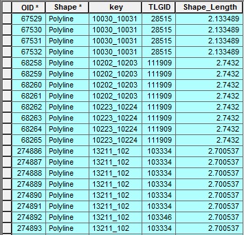
I'm dissolving a line feature class with over 400k rows of data based on two fields: 1) Key 2) TLGID.
However, when I run the dissolve with single feature activated, some smaller lines disappear altogether. When I change the setting to multi-feature and run the dissolve again, I get shape_lengths of 0 for those same lines that disappeared before. I've attached photos of the before and after the multi-feature dissolve.
BEFORE multi-feature dissolve:
AFTER multi-feature dissolve:

Is there a cluster tolerance that is set by default that deletes segments that don't meet a minimum length? In my case 2.8 meters...
- Mark as New
- Bookmark
- Subscribe
- Mute
- Subscribe to RSS Feed
- Permalink
I don't know if this is the case for your data, but the ESRI tool help does mention that the tool uses an adaptive tiling process to handle large datasets.
The availability of physical memory may limit the amount (and complexity) of input features that can be processed and dissolved into a single output feature. This limitation could cause an error to occur, as the dissolve process may require more memory than is available. To prevent this, Dissolve may divide and process the input features using an adaptive tiling algorithm. To determine the features that have been tiled, run the Frequency tool on the result of this tool, specifying the same fields used in the dissolve process for the Frequency Field(s) parameter. Any record with a frequency value of 2 has been tiled. Tile boundaries are preserved in the output features to prevent the creation of features that are too large to be used by ArcGIS.
ArcGIS Help 10.1 Dissolve (Data Management)
Chris Donohue, GISP