- Home
- :
- All Communities
- :
- Products
- :
- Geoprocessing
- :
- Geoprocessing Questions
- :
- Re: Deriving Slope Position
- Subscribe to RSS Feed
- Mark Topic as New
- Mark Topic as Read
- Float this Topic for Current User
- Bookmark
- Subscribe
- Mute
- Printer Friendly Page
Deriving Slope Position
- Mark as New
- Bookmark
- Subscribe
- Mute
- Subscribe to RSS Feed
- Permalink
I'm currently running an analysis to determine structure locations (which are polygons) relative to slope positions. I need to determine if they are a) at the bottom of a slope b) Mid-Slope on a bench c) Mid-Slope continuous or d) on the upper portion of the slope.
Any ideas would be great, thanks ahead of time.
- Mark as New
- Bookmark
- Subscribe
- Mute
- Subscribe to RSS Feed
- Permalink
There are lots of tools to calculate terrain derivatives such as slope, aspect, curvature etc etc.
There are few to none, to account for or produce the macroscale information that you need.
You could produce a slope map (ie degree or % slope), then categorize it into what you consider a slope of importance. For example, you can have a 'slope' which is 3 degrees that contains all the required parameters you are looking for... but are you interested in 'slopes' that have a particular slope (degrees, %) and areal coverage (m^2, hectare, acre etc)
Decide on that critera, delimit the areas that have that kind of slope and areal coverage.
Once you have made those decisions... I am sure you will have more criteria to add... get back to the thread then
- Mark as New
- Bookmark
- Subscribe
- Mute
- Subscribe to RSS Feed
- Permalink
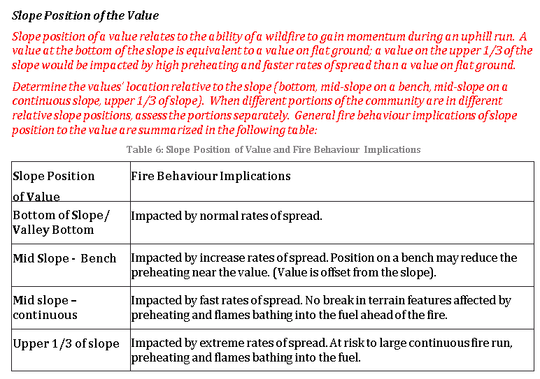
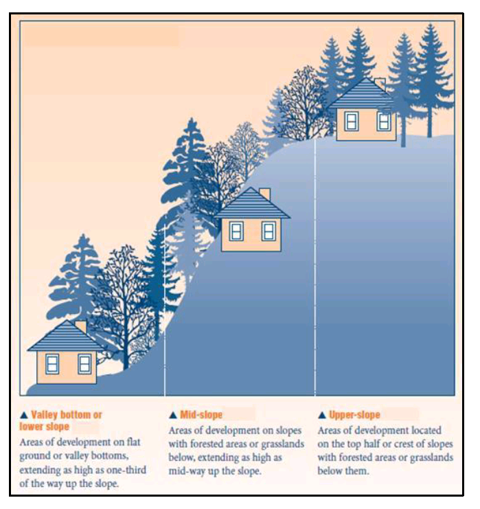
Some context: This is part of a wildfire threat model, there are a total of 5 inputs which I need to use in a weighted overlay. One of them, for example is slope % at certain intervals. I've already created the slope from the DEM and reclassified the slope into the proper parameters.
The input I'm having difficulty with is the slope position, I would imagine it could be derived with some combination of the DEM and slope rasters?
- Mark as New
- Bookmark
- Subscribe
- Mute
- Subscribe to RSS Feed
- Permalink
I am familiar with the context, my procedures are to delineate those 'candidate areas'
After this stage, you can use bounding containers of some incarnation (eg minimum area bounding rectangle, minimum area bounding ellipse ) which will give you the orientation of the areas and the long and short axes of the oriented container. If all goes well, then you will have the upslope axis, from start to finish. That will give you the midslope position.
If the mid-slope axis connects to a flat area top and bottom (meeting your criteria for flat), then you have your information.
If you complete what I suggested, showing a map of you results relative to the terrain may provide a discussion point. (PS, there are fire modelling tools out there, I just don't remember if they are gis based or not)
- Mark as New
- Bookmark
- Subscribe
- Mute
- Subscribe to RSS Feed
- Permalink
You can also use the Topographical Positional Index (TPI) to determine position along a slope. If you are using ArcMap, then there is a really useful add-on that was developed by Jenness Enterprises that will easily calculate and categorise this for you. The add-on is free and part of the Land Facet Corridor designer tool. See Jenness Enterprises - ArcGIS Tools; Land Facet Corridor Designer
The Slope Position 3-category output may give you what you are looking for.
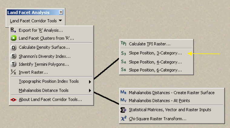
The documentation is really good and will help with the installation and setting some of the parameters.
If you are using ArcGIS Pro, then you can more-or-less accomplish the same thing using Focal Statistics and Raster Calculator, you will just need to categorise the output yourself afterwards.
- Mark as New
- Bookmark
- Subscribe
- Mute
- Subscribe to RSS Feed
- Permalink
Wow! What a fantastic tool/extension Mervyn - Thank you so much for passing this information along.
I was working with a DEM produced from TRIM Data for this project - I'm going to test it on an area with with LiDAR data and I can't wait to see the results.