- Home
- :
- All Communities
- :
- Products
- :
- Geoprocessing
- :
- Geoprocessing Questions
- :
- Re: Create Quarter sections lines
- Subscribe to RSS Feed
- Mark Topic as New
- Mark Topic as Read
- Float this Topic for Current User
- Bookmark
- Subscribe
- Mute
- Printer Friendly Page
- Mark as New
- Bookmark
- Subscribe
- Mute
- Subscribe to RSS Feed
- Permalink
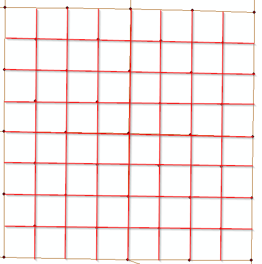
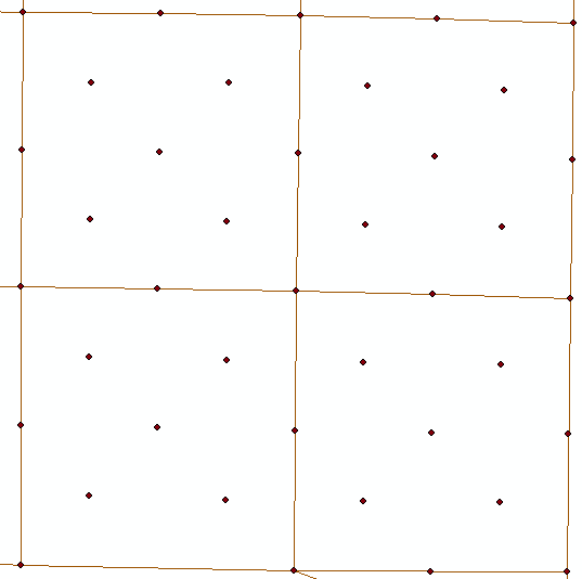
I have polylines of the sections and monuments. I need to create quarter sections lines. I am not sure what is the best way to achieve this without connecting the lines manual. I am sure some one has come across this before. So if anyone can help me out that would be awesome. Pic 1 show what i have and pic.2 is what i am trying to achieve.
Solved! Go to Solution.
Accepted Solutions
- Mark as New
- Bookmark
- Subscribe
- Mute
- Subscribe to RSS Feed
- Permalink
Sorry about that, it was a coding error, updated code attached. I tested with your point layer and it seems to work fine.
- Mark as New
- Bookmark
- Subscribe
- Mute
- Subscribe to RSS Feed
- Permalink
You can use copy parallel in Editor toolbar as in the picture :
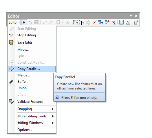
Just define the quarter distance and select the line/lines and copy parallel.
- Mark as New
- Bookmark
- Subscribe
- Mute
- Subscribe to RSS Feed
- Permalink
That would work if the sections line where equal distance but they are not. I need to be able to snap point to point to create the quarter lines.
- Mark as New
- Bookmark
- Subscribe
- Mute
- Subscribe to RSS Feed
- Permalink
in your picture I see it is equal distance, so I answered with copy parallel
- Mark as New
- Bookmark
- Subscribe
- Mute
- Subscribe to RSS Feed
- Permalink
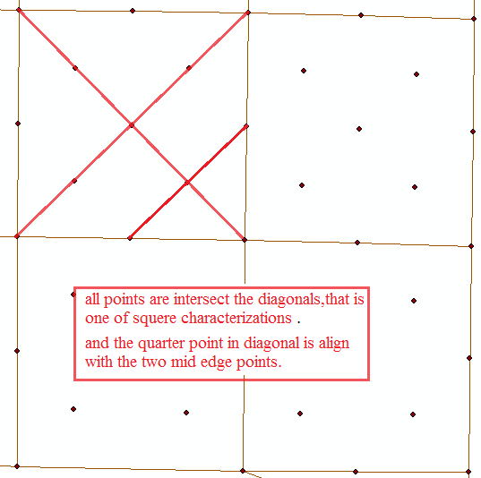
They look like equal distance but they are not but some might be. The county is odd shape and we have government lots so those are not a full section.
- Mark as New
- Bookmark
- Subscribe
- Mute
- Subscribe to RSS Feed
- Permalink
Do you have 10's, 100's or 1000's to do?
- Mark as New
- Bookmark
- Subscribe
- Mute
- Subscribe to RSS Feed
- Permalink
Dan, we have 654 sections.
- Mark as New
- Bookmark
- Subscribe
- Mute
- Subscribe to RSS Feed
- Permalink
hmmm there is probably nothing in the point table that would enable you to identify which points belong to which quarter section. That might be useful for a connecting the dots approach
- Mark as New
- Bookmark
- Subscribe
- Mute
- Subscribe to RSS Feed
- Permalink
Point of clarification - if I understand correctly, you have all the lines depicted in the first example, but need to cull them down to only the quarter section ones (so a subset) - is that correct? If that is the case, are the lines already attributed so you know which ones are the section lines (so there is a basis to then do the quarter-sections)?
Also, points are shown in the examples. Are the points attributed in any way that would help define which lines are section lines and which ones are quarter-sections? I ask as one way to do this might be to build the lines from the points using Points to Lines, but before doing so the points will need attributes that allow the correct assembly.
Points To Line—Help | ArcGIS for Desktop
Another question - are the lines all roughly North-South and East-West, or are some of them in other orientations (like NW-SE)? If they are all North-South and East-West, one may be able use their increasing X or Y values to help in differentiating them.
Chris Donohue, GISP