- Home
- :
- All Communities
- :
- Products
- :
- Geoprocessing
- :
- Geoprocessing Questions
- :
- Create Quarter sections lines
- Subscribe to RSS Feed
- Mark Topic as New
- Mark Topic as Read
- Float this Topic for Current User
- Bookmark
- Subscribe
- Mute
- Printer Friendly Page
- Mark as New
- Bookmark
- Subscribe
- Mute
- Subscribe to RSS Feed
- Permalink
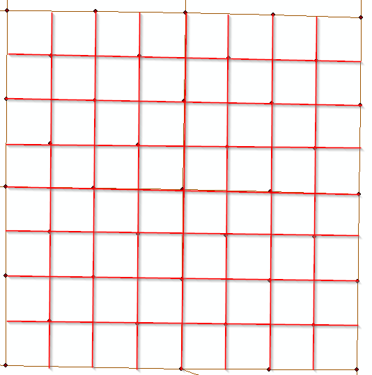
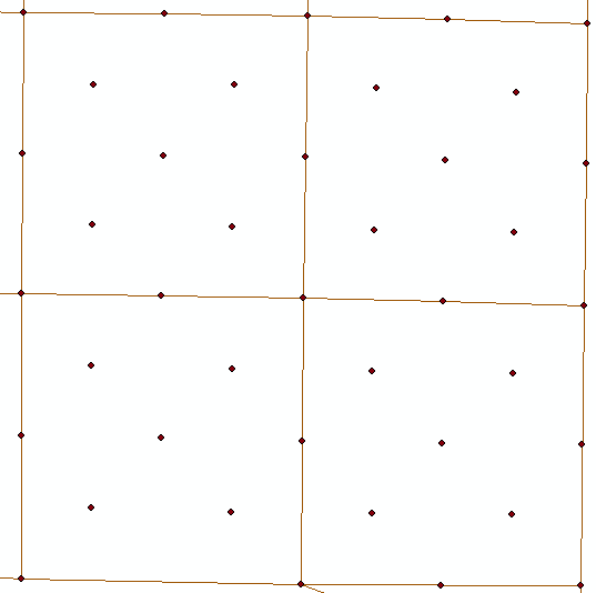
I have polylines of the sections and monuments. I need to create quarter sections lines. I am not sure what is the best way to achieve this without connecting the lines manual. I am sure some one has come across this before. So if anyone can help me out that would be awesome. Pic 1 show what i have and pic.2 is what i am trying to achieve.
Solved! Go to Solution.
- Mark as New
- Bookmark
- Subscribe
- Mute
- Subscribe to RSS Feed
- Permalink
maybe my suggest is not clear, but I said we will make classes the is for group each line.
you will define the tolerance and group each align points horizontal into class and vertical points into class( the point has two classes one for vertical and other for horizontal)
the correct is you will define the tolerance and group each align points horizontal into classes and vertical points into classes( ech point has two classes one for vertical and other for horizontal)
1and I said that we will use sort twice one for horizontal and one for vertical.
and use Sort tool again for vertical and y fields.
so we will use point to line twice either one for vertical and other for horizontal. And by using classes that I mentioned in point to line the line will never draws as your picture , Chris
- Mark as New
- Bookmark
- Subscribe
- Mute
- Subscribe to RSS Feed
- Permalink
If the data is not perfectly North/South and East/West, an approach that would work that builds on what Abdullah Anter suggested would be to create a North/South and East West exact grid that covers the extent of your points by using Grid Index Features (geoprocessing tool), then derive the Sort Order for that Grid. Next, Spatial Join (geoprocessing tool) the grid to your actual points (so the sort order gets transferred over). Then you can run Abdullah's suggestion based on the exact grid sort order fields so the lines are drawn in the correct sequence (as opposed to the real points sort order, which can lead to backtracks).
Grid Index Features—Help | ArcGIS for Desktop Geoprocessing Tool
Spatial Join—Help | ArcGIS for Desktop Spatial Join Geoprocessing Tool. For the "Match Option" setting, use "Have their Center in"
Chris Donohue, GISP
- Mark as New
- Bookmark
- Subscribe
- Mute
- Subscribe to RSS Feed
- Permalink
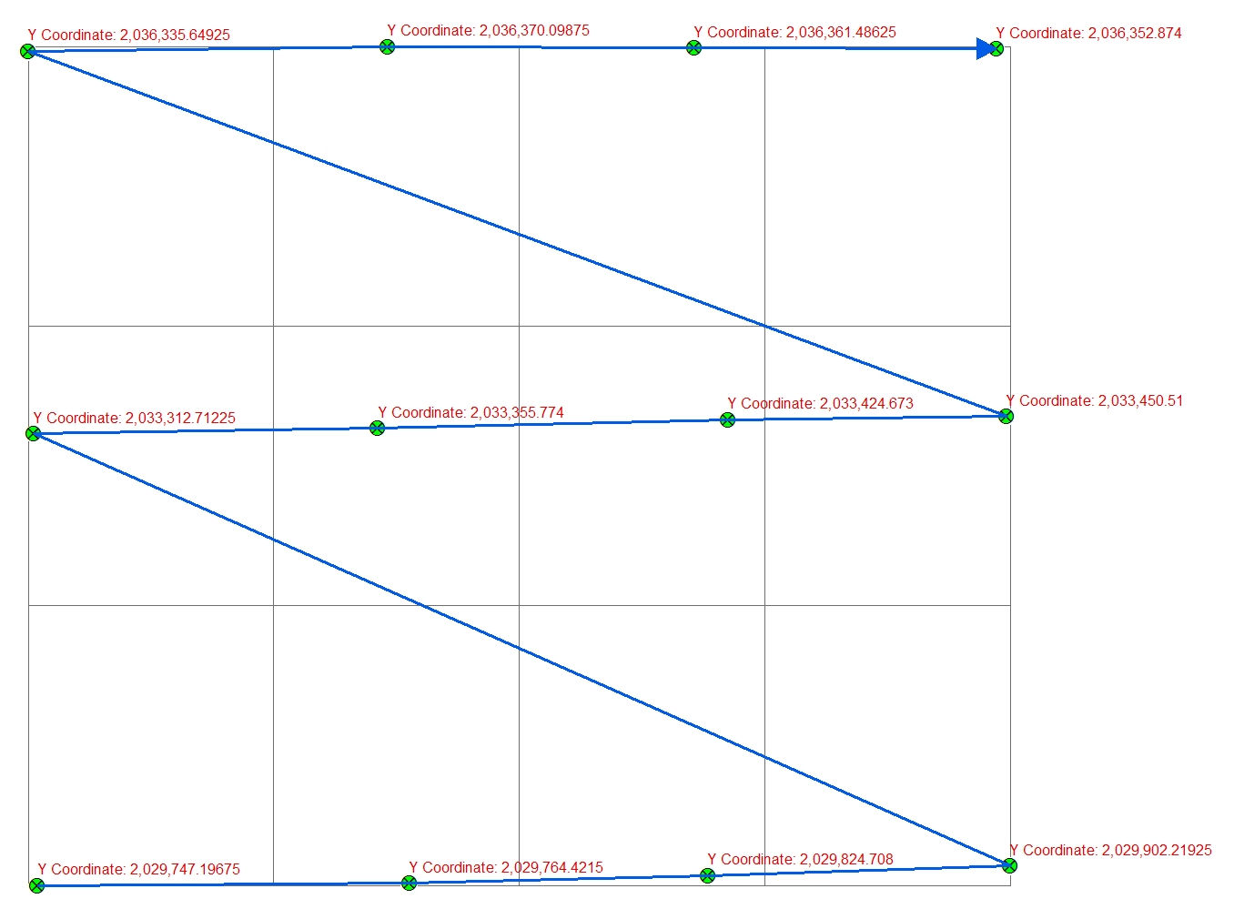
Chris i tried your approach and i ran into some issues. so when i used the 'Grid Index Features' tool on the monument points i just created one big polygon that covered all the points. You stated that i should 'Sort order on Grid' problem is that there is only one polygon that was generated from the 'Grid Index Features' tool. So I am not sure if am not understand you.
- Mark as New
- Bookmark
- Subscribe
- Mute
- Subscribe to RSS Feed
- Permalink
I didn't go into detail on how to use Grid Index Features, so sorry for the confusion. The deal with using this tool is one needs to fill in several of the settings, some of which are not intuitive.
Input Features (optional): use your points layer
Number of Rows (optional): Number of the maximum count of points in the X dimension
Number of Columns (optional): Number of the maximum count of points in the Y dimension
Then run it. Note that the goal is to have one "box" (in the GridIndex) per point. Note that the resulting grid will have the points somewhat scattered around each box, i.e. the points won't be exactly in the same point in each box. But that's OK, we're using the grid (boxes) purely to derive the sort order, not as a final result.
In the resulting GridIndex, there will be a field called "PageNumber". That field represents the draw order for East-West, so that one is ready to go if you don't mind that it will create the extra diagonal lines as it creates the East-West linework (details on how to clean that up below).
The North-South order will need some processing of the existing attributes to derive it. Start by creating a new field (text) in the GridIndex like "SortNorthSouth" (Short Integer). Then use Field Calculator with the following VB statement (or use the Python equivalent):
Right( [PageName],1 )
Note that you may have to play with the value after the [PageName], depending upon how many digits your numbers have to correctly capture the value. For example, if the number values go up to 99, use ",2".
You will now have a grid that can be Spatial Joined to the points that will provide the proper order for lines to be drawn to the points.
Target: Your points
Join Features: the GridIndexFeatures
Match Option (optional): HAVE_THEIR_CENTER_IN
Next is the Feature to Line Geoproccesing Tool on your joined points, with one run for the NorthSouth lines and a second run to do the East-West lines:
- For each run use the Sort Field (optional) set to the field that provides the sorting.
The final result will look weird at first and need some final cleanup:
-The North-South lines will have some East-West segments.
-The East-West lines will have diagonal segments.
I'd start by getting rid of the diagonal lines in the East-West linework by starting an editing session and manually selecting and deleting them. There's probably a more elegant way to do this, but I'm blank at the moment on how to do it.
As for the unwanted East-West segments as part of the North-South linework, there are several options to eliminate them, but the easiest is probably to Union the North-South layer with the cleaned up (no diagonals) East-West linework, then taking the output and running a Dissolve on it.
Note that if at the end of all this you need their to be distinct lines between each point, there are several methods available to break up the lines at intersections and points.
Methods for splitting line features—Help | ArcGIS for Desktop
Anyways, give this a shot. There may have to be a few tweaks here or there to fine-tune it for your data, but it should work.

Chris Donohue, GISP
- Mark as New
- Bookmark
- Subscribe
- Mute
- Subscribe to RSS Feed
- Permalink
before doing an dissolve i used the 'integrate' tool to clean up the lines, then used 'Dissolve' and it cleaned up the line work pretty good. Thanks!
- Mark as New
- Bookmark
- Subscribe
- Mute
- Subscribe to RSS Feed
- Permalink
I also have wanted to do this but cutting quarters into LSDs. So same concept just smaller squares.
I have not found a tool that does this. The parcel fabric tools allow one to do this but only manually with many steps. I require an automated approach since there are many thousands of quarter sections to split up.
The approach I was working on but have not completed was to create an iterative model that would:
1. Select a quarter section polygon.
2. Convert to four polylines of the quarter section outline.
3. Create mid-points for all four lines.
4. Create polylines from these mid-points so that two lines half the quarter section east-west and north-south.
5. Cut the quarter section with these polylines.
6. Label the new LSDs.
Repeat thousands of times.
The problem, besides running out of time, was that I couldn't sort the mid-points to ID which one's were east, west, north, south to make the bisecting polylines. But it seemed like this would work based on a few tests.
- Mark as New
- Bookmark
- Subscribe
- Mute
- Subscribe to RSS Feed
- Permalink
Perhaps I'm late to the game but I found a Python toolbox that handles quarter sections plus labels well - http://ianbroad.com/creating-quarter-quarter-section-grid-python/
- Mark as New
- Bookmark
- Subscribe
- Mute
- Subscribe to RSS Feed
- Permalink
Right, I've used that tool and it works well. But doesn't do what this person is asking, as it doesn't take into account existing PLSS corners...
- Mark as New
- Bookmark
- Subscribe
- Mute
- Subscribe to RSS Feed
- Permalink
thanks to all that helped. I tried multiple ways and found that both suggestions from Chris Ringo and Chris Donohue worked. Each one will require some manual work but better than doing it all manually.