- Home
- :
- All Communities
- :
- Products
- :
- Geoprocessing
- :
- Geoprocessing Questions
- :
- Create Quarter sections lines
- Subscribe to RSS Feed
- Mark Topic as New
- Mark Topic as Read
- Float this Topic for Current User
- Bookmark
- Subscribe
- Mute
- Printer Friendly Page
- Mark as New
- Bookmark
- Subscribe
- Mute
- Subscribe to RSS Feed
- Permalink
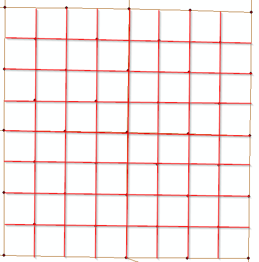
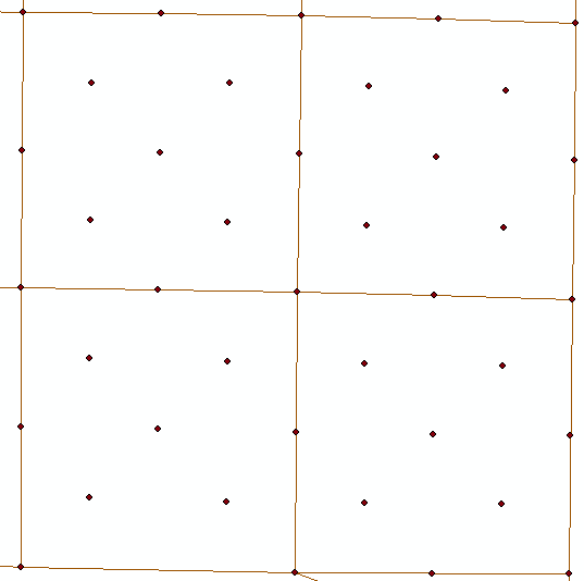
I have polylines of the sections and monuments. I need to create quarter sections lines. I am not sure what is the best way to achieve this without connecting the lines manual. I am sure some one has come across this before. So if anyone can help me out that would be awesome. Pic 1 show what i have and pic.2 is what i am trying to achieve.
Solved! Go to Solution.
- Mark as New
- Bookmark
- Subscribe
- Mute
- Subscribe to RSS Feed
- Permalink
Oh, sorry I forgot to tell you - the same thing happened to me. The script works from the XY coordinate fields in the attribute table of your point layer. You'll need to re-calculate geometry on those fields in your test layer, as they are incorrect in the layer you sent.
- Mark as New
- Bookmark
- Subscribe
- Mute
- Subscribe to RSS Feed
- Permalink
It would take some more work, yes, and I really don't have any more time to spend on this. But you said you already had the section lines, correct? You can just merge the two together and you'll have everything you need.
- Mark as New
- Bookmark
- Subscribe
- Mute
- Subscribe to RSS Feed
- Permalink
no problem, thanks for the help.
- Mark as New
- Bookmark
- Subscribe
- Mute
- Subscribe to RSS Feed
- Permalink
I suspect you have completed this manually by now? 
- Mark as New
- Bookmark
- Subscribe
- Mute
- Subscribe to RSS Feed
- Permalink
CC Weedcontrol ,if your quarter lines align from north to south and from west to east, there is a solution for your issue.
the points are align horizontal and vertical .and that is the clue
the solution is :
Frist : it is attribute task . you will add x and y coordinates field Add XY Coordinates—Help | ArcGIS Desktop
so you can classify each align points into classes , you will define the tolerance and group each align points horizontal into class and vertical points into class( the point has two classes one for vertical and other for horizontal)
Second :you will use Sort Tool Sort—Help | ArcGIS Desktop and you will add two fields for sort ( first horizontal class field , second x field)
and use Sort tool again for vertical and y fields.
Third : now you can get your quarter lines if you use Point To Line Tool Points To Line—Help | ArcGIS Desktop and use ID field of sort in this tool. And class field for line field in this tool.
I hope my answer be clear.
- Mark as New
- Bookmark
- Subscribe
- Mute
- Subscribe to RSS Feed
- Permalink
The layer already had x,y i just updated the the fields. I used the 'Sort' and i added the two fields y,x which with made an out put of 'Monuments_points_sort', then i did the 'Sort' again as stated on the 'Monuments_points_sort' and i added the two fields x,y which made an out put of 'Monuments_points_sort_sort'. I then used the 'Points to Line' on 'Monuments_points_sort_sort': Line field i used 'Corner_type', in the soft field is used 'ObjectID'. which gave me an error
RuntimeError: ERROR 999999: Error executing function.
Completed script PointsToLine...
Failed to execute (PointsToLine).
- Mark as New
- Bookmark
- Subscribe
- Mute
- Subscribe to RSS Feed
- Permalink
Did you classify your lines before sort?
Did you sort based on one field or the two fields ?
add two fields for sort ( first horizontal class field , second x field)
- Mark as New
- Bookmark
- Subscribe
- Mute
- Subscribe to RSS Feed
- Permalink
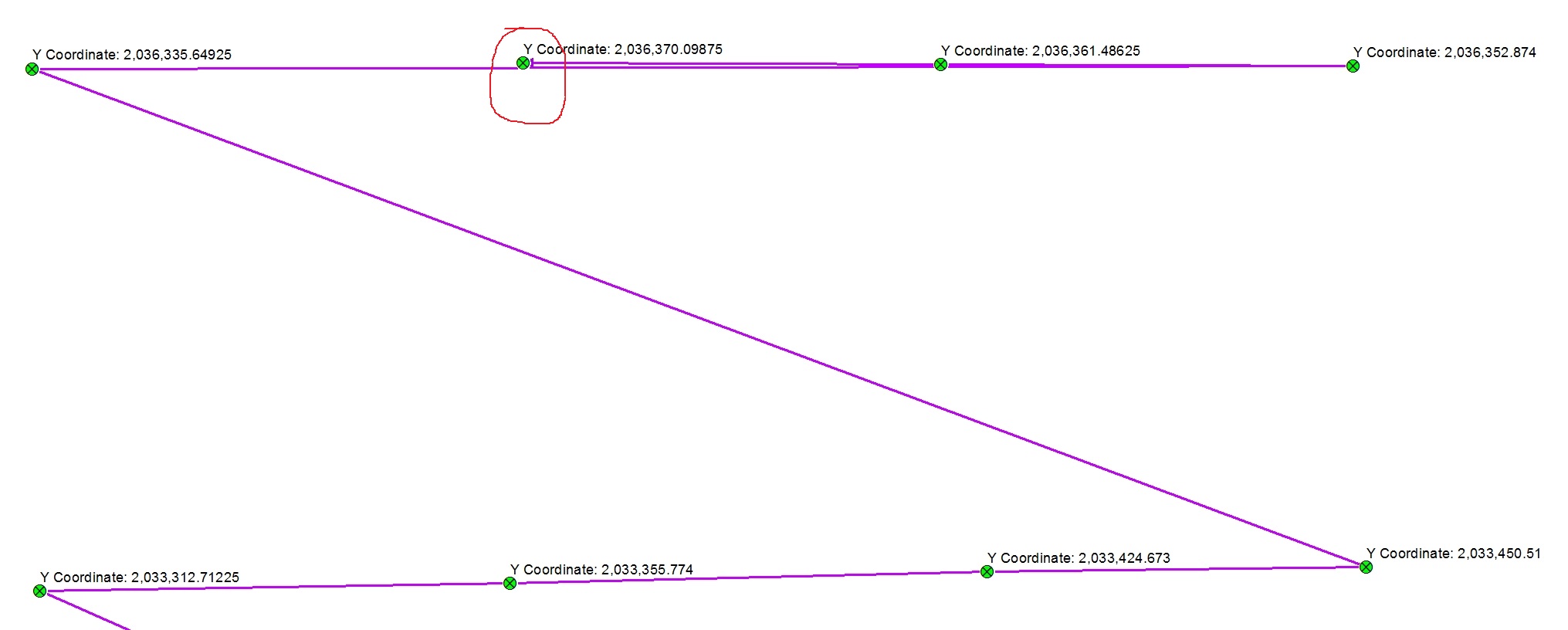
Abdullah Anter has an good approach. However, check the output carefully, as unfortunately there will likely be issues if all your points are not all aligned exactly North/South and East/West. If they are not aligned exactly, some of the resulting lines will be "backtracking" and require some cleanup. Still, this is a good start that may resolve most of your lines (and probably be easier than drawing all the lines manually).
For example, note that the Y value for the point circled in red is slightly higher than the Y values for the points on either side. When the line is drawn automatically, it bypasses this point, then backtracks later to it.
Chris Donohue, GISP