- Home
- :
- All Communities
- :
- Products
- :
- Geoprocessing
- :
- Geoprocessing Questions
- :
- Re: Create polygons that group certain number of p...
- Subscribe to RSS Feed
- Mark Topic as New
- Mark Topic as Read
- Float this Topic for Current User
- Bookmark
- Subscribe
- Mute
- Printer Friendly Page
Create polygons that group certain number of points in ArcGIS
- Mark as New
- Bookmark
- Subscribe
- Mute
- Subscribe to RSS Feed
- Permalink
I have about 20000 points and I want to create polygons where each polygon contain 200 points, so there should be 20000/200=100 polygons. I want to do that with ArcGIS 10.4.
Solved! Go to Solution.
Accepted Solutions
- Mark as New
- Bookmark
- Subscribe
- Mute
- Subscribe to RSS Feed
- Permalink
also look at Mapping Clusters tools
- Mark as New
- Bookmark
- Subscribe
- Mute
- Subscribe to RSS Feed
- Permalink
What rules are you using for the grouping?
some possibilities...
- split the points based on sequential number
- spatially sort the points then group by sorted idea
- group based on a distance (this is difficult because getting 200 exactly is nearly impossible, so you would have to iterate and subdivide.
- Mark as New
- Bookmark
- Subscribe
- Mute
- Subscribe to RSS Feed
- Permalink
I just want these groups to contain 200 points and to touch boundaries like on the example bellow.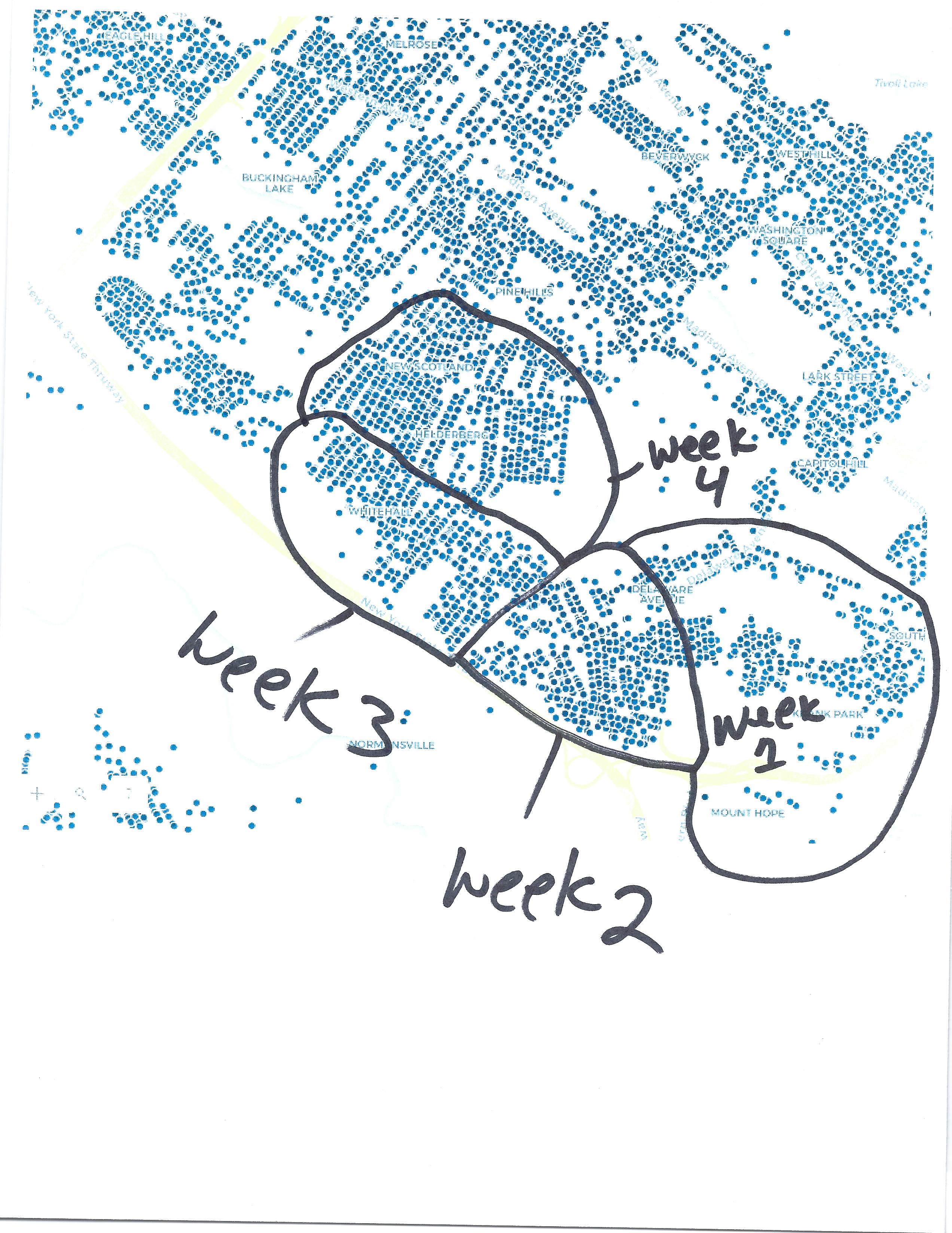
- Mark as New
- Bookmark
- Subscribe
- Mute
- Subscribe to RSS Feed
- Permalink
The quickest way to do that is to use the selector tool, highlight a selection that you have done, use the field calculator to put in a 'key' value (ie week1, week 2 etc).
In any event, you are going to have to draw the boundary. If you had to reuse this boundary, then you could produce the boundary layer, then do a select by attribute or spatial join.
If you need them as separate files, then use the Split layer tool if you and advance license... or since you are using an old arcmap Split Layer By Attribute works for all license levels
- Mark as New
- Bookmark
- Subscribe
- Mute
- Subscribe to RSS Feed
- Permalink
So I guess that this idea is that what I need:
- spatially sort the points then group by sorted idea
- Mark as New
- Bookmark
- Subscribe
- Mute
- Subscribe to RSS Feed
- Permalink
as for sorting, a standard spatial sort isn't going to help.
A radial sort around area centroids might help you identify the closest, but given your layout of the zones you are working with... you would be done doing it manually before you finished fine-tuning that.
I do have tools for radial sort but they are for ArcGIS Pro
This sounds similar to one of your other unclosed threads
- Mark as New
- Bookmark
- Subscribe
- Mute
- Subscribe to RSS Feed
- Permalink
This related post might contain some additional relevant info: https://community.esri.com/message/687863-re-group-every-near-50-points-together?commentID=687863#co...
- Mark as New
- Bookmark
- Subscribe
- Mute
- Subscribe to RSS Feed
- Permalink
Great! That works. Now I just want to create polygons that contain points based on attribute value of each point. Also I need these polygons just to touch boundaries, not to overlap each other.
- Mark as New
- Bookmark
- Subscribe
- Mute
- Subscribe to RSS Feed
- Permalink
Might be worth looking at Creating Polygons Based on Point Count in ArcGIS for Desktop? - Geographic Information Systems Stack...
- Mark as New
- Bookmark
- Subscribe
- Mute
- Subscribe to RSS Feed
- Permalink
Generate Subset Polygons was launched in ArcGIS Pro 2.1