Turn on suggestions
Auto-suggest helps you quickly narrow down your search results by suggesting possible matches as you type.
Cancel
- Home
- :
- All Communities
- :
- Products
- :
- Geoprocessing
- :
- Geoprocessing Questions
- :
- Re: Consolidating points in a 50 meter radius
Options
- Subscribe to RSS Feed
- Mark Topic as New
- Mark Topic as Read
- Float this Topic for Current User
- Bookmark
- Subscribe
- Mute
- Printer Friendly Page
Consolidating points in a 50 meter radius
Subscribe
7613
9
10-13-2011 09:52 AM
10-13-2011
09:52 AM
- Mark as New
- Bookmark
- Subscribe
- Mute
- Subscribe to RSS Feed
- Permalink
I am trying to consolidate any points that fall within a fifty meter radius of another plot, combining the data into single point that covers the 50 meter area. Would anyone have any suggestions on how I could do this? Thanks!
9 Replies
10-13-2011
10:48 AM
- Mark as New
- Bookmark
- Subscribe
- Mute
- Subscribe to RSS Feed
- Permalink
Can you expand on your question? Do you want one point in the end, or literally a polygon that covers the 50m area. Also, what happens if there are 3 points in a row, each 30m apart?
10-13-2011
11:14 AM
- Mark as New
- Bookmark
- Subscribe
- Mute
- Subscribe to RSS Feed
- Permalink
Thanks for your reply! Sorry about the poorly worded question, I'm a little new at GIS, so I'll try and make more sense out of this one... I have a series of aerial survey sites represented by points. Each of the points indicates the number of disease damaged trees counted in a roughly 50 meter radius, although it doesn't end up being exact, so some points are only sepearate by a few meters. These trees contained in the point are going to be put out for contract to be removed. I'd like to try and thin out the number of points that will be on the contract maps by consolidating the data in the points that are close together into a single point that represents all the points that might have been in each 50 meter radius of the original data
10-13-2011
11:16 AM
- Mark as New
- Bookmark
- Subscribe
- Mute
- Subscribe to RSS Feed
- Permalink
...sorry, guess I didn't really answer the question. I'd still like a series of points, just less of them by consolidating any ones less then fifty meters apart into less points
10-13-2011
12:20 PM
- Mark as New
- Bookmark
- Subscribe
- Mute
- Subscribe to RSS Feed
- Permalink
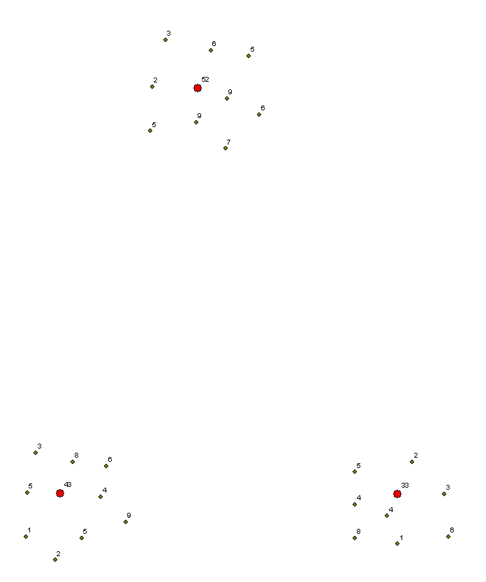
If your data is fairly simple (like attached), you can use a Spatial Join. Use the tool in the toolbox, not from the ArcMap menu.
Target Features = points at the middle of each cluster
Join Features = count data
Join Operation = JOIN_ONE_TO_ONE
*** Right-click the column that holds your count data, change merge rule to SUM ***
Match Option = Intersect
Search Radius = 50m
Target Features = points at the middle of each cluster
Join Features = count data
Join Operation = JOIN_ONE_TO_ONE
*** Right-click the column that holds your count data, change merge rule to SUM ***
Match Option = Intersect
Search Radius = 50m
10-13-2011
03:09 PM
- Mark as New
- Bookmark
- Subscribe
- Mute
- Subscribe to RSS Feed
- Permalink
Using Spatial Join you should be able to associate every point in dataset 1 to a point in dataset1 if within 50m. So some points in dataset1 get the point IDs of dataset2.
To group points of dataset1 by the associated point IDs of dataset2 and then turn each group into a point, you can try the following (requiring ArcInfo license):
1. Use Dissolve tool with the associated Point ID of dataset2 as the Dissolve Field. By default each group of points will become one mpoint feature.
2. Use Feature To Point tool on the mpoint features, using the default CENTROID option. You should have one point for each group of points now.
Is that what you want to achieve?
10-15-2011
09:43 AM
- Mark as New
- Bookmark
- Subscribe
- Mute
- Subscribe to RSS Feed
- Permalink
@ajr.lawrence:
Do you have two separate point feature classes - desired points in one layer and the closer by (to be consolidated) points in another? If yes, then the above solution will work for you.
If they (all points) are in one feature class then you'll need to follow extra steps or a separate path. Let us know.
10-21-2011
08:17 AM
- Mark as New
- Bookmark
- Subscribe
- Mute
- Subscribe to RSS Feed
- Permalink
You could use the Integrate (Data Management) tool.
input your point feature class and set a 50 meter cluster tolerance.
DO IT ON A COPY OF YOUR POINT FILE!
Integrate changes the data in your file!
Integrate snaps the points within the tolerance to a single location: you get little stacks of coincident points.
You can then use Collect Events (Spatial Statistics) to create a single point of the points in each stack. The output will have an ICount item showing the number of points at that location (handy for proportional symbols).
You can use this feature class for one of the two for the Spatial Join Dan suggests above, and the 'integrated' stacks of points for the other.
That should give you what you want....
10-21-2011
10:21 AM
- Mark as New
- Bookmark
- Subscribe
- Mute
- Subscribe to RSS Feed
- Permalink
Just a friendly reminder on the Integrate tool:
This tool uses an iterative clustering process which may end up snapping points that are farther away than the specified XY tolerance to a new location. It is intended for use with relatively small tolerances so that the errors are minimal. Using it for spatial clustering over a large distance may give you an inaccurate result. You can use Buffer on the new location points to inspect/verify the result.
This tool uses an iterative clustering process which may end up snapping points that are farther away than the specified XY tolerance to a new location. It is intended for use with relatively small tolerances so that the errors are minimal. Using it for spatial clustering over a large distance may give you an inaccurate result. You can use Buffer on the new location points to inspect/verify the result.
10-21-2011
10:38 AM
- Mark as New
- Bookmark
- Subscribe
- Mute
- Subscribe to RSS Feed
- Permalink
Very true. Any automated process like integration has inherent dangers. If, as is suggeted above, one has a cloud of points 30 meters apart, and then set a 50 meter tolerance, the integrated points could land just about anywhere...
Picking an appropriate tolerance may take a few tries, and careful inspection of results.
Picking an appropriate tolerance may take a few tries, and careful inspection of results.