- Home
- :
- All Communities
- :
- Products
- :
- Geoprocessing
- :
- Geoprocessing Questions
- :
- Re: Breaking sections by chainage values
- Subscribe to RSS Feed
- Mark Topic as New
- Mark Topic as Read
- Float this Topic for Current User
- Bookmark
- Subscribe
- Mute
- Printer Friendly Page
Breaking sections by chainage values
- Mark as New
- Bookmark
- Subscribe
- Mute
- Subscribe to RSS Feed
- Permalink
Hi everyone,
quick question. I have a shapefile with the road network in terms of road sections. Each section is represented by a unique field in the table. I am processing some data from Excel that include each section multiple times. Now, two important fields in the Excel are start Chainage and End Chainage. I need to break down the above sections into these "new sections" with regard to the chainage lengths and create a new shapefile. Each of these lengths represents a different value that needs to be plotted accordingly.
Thanks in advance...
- Mark as New
- Bookmark
- Subscribe
- Mute
- Subscribe to RSS Feed
- Permalink
Could you post an example of what you are trying to do? Sounds like you are selecting a street segment then getting the intersecting segments, but i'm not clear with your description.
- Mark as New
- Bookmark
- Subscribe
- Mute
- Subscribe to RSS Feed
- Permalink
Wes thanks for the quick reply.
So let me explain. I've got a map with the road network, where each section is represented by certain attributes (Section 1, Section 2, etc with additional info such as lengths, lanes, description etc). I am now processing some data in an Excel which contains the same sections as before. The point is that within these data, each section has more than one attribute values. E.g. In the shapefile Section 1 has a length of 2km. In the spreadsheet the same section has been divided into more than one "parts", according to the chainage (0-10m, 10-20m,.. 1990m-2km). Each "part" is associated with a different value, say for example from 0-10m there is a value of 1mm, from 10-20m a value of 2.5mm and so on. These values are the ones that I need to show in my map. However, I cannot find a way to give this spatial information to my table and create a shapefile. Of course, I can't join the tables since the relationship is 1:M and I'll lose the rest of each section's values.
Does this help?
- Mark as New
- Bookmark
- Subscribe
- Mute
- Subscribe to RSS Feed
- Permalink
A picture may demonstrate a little better what you are trying to do. I think you are trying to do Linear referencing datasets in ArcGIS—Linear Referencing | ArcGIS for Desktop
- Mark as New
- Bookmark
- Subscribe
- Mute
- Subscribe to RSS Feed
- Permalink
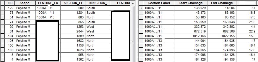
Thanks for the reply. So, on the left I've got a shapefile with sections and their lengths. On the right side I've got an analysed table with the same sections, although they appear more than one times. So, for section 1000A/1 I need to attach the value of 17 only in the chainage between 138.029 and 148.04. In addition, for section 1000A/11 for example I need to include the values of 16.8, 17.3, 21.8, 4.4, 22.9 and 15.3 in different chainages. The same occurs to more than 100 sections, so a manual way is not an option.
- Mark as New
- Bookmark
- Subscribe
- Mute
- Subscribe to RSS Feed
- Permalink
Actually, I've managed to isolate the preferred chainage lengths by right-click in the table in the TOC and Display Route Events (linear referencing as you said). However, the selections are visible in the map but the attribute table is empty. I've tried to join the newly created table (the one with the route events) with my initial shapefile that contains the sections as whole lengths. The join works, meaning that I get a new table that has all the information that I need but after the join no lines are visible in the map. And still, since there is no spatial connection I'm left with a table or layer instead of a new shapefile.
- Mark as New
- Bookmark
- Subscribe
- Mute
- Subscribe to RSS Feed
- Permalink
When you did the Display Route Events dialog did you specify to create a LOC_ERROR field? This will help you find those records in your table which did not match via your FEATURE_LA / Section Label route id field.
And, if those are spaces in those field names, I would get rid of them. Spaces in field names can result in all sorts of strange things happening.
- Mark as New
- Bookmark
- Subscribe
- Mute
- Subscribe to RSS Feed
- Permalink
Thanks for the reply. It gives me a message saying: The table you specified does not have an Object-ID Field so you will be not able to select or edit the features in the resulting layer (apparently that's why my table is empty). However, I've got an OID Field set in my table. I am not sure how to proceed.
- Mark as New
- Bookmark
- Subscribe
- Mute
- Subscribe to RSS Feed
- Permalink
Try using the Table To Table—Help | ArcGIS for Desktop tool
- Mark as New
- Bookmark
- Subscribe
- Mute
- Subscribe to RSS Feed
- Permalink
I don't think so. Done this many times.
Are you sure that your route identifier field on both sides actually match?
And I would still get rid of any spaces in the attribute names.