Turn on suggestions
Auto-suggest helps you quickly narrow down your search results by suggesting possible matches as you type.
Cancel
- Home
- :
- All Communities
- :
- Products
- :
- Geoprocessing
- :
- Geoprocessing Questions
- :
- Assign point feature values to polygons
Options
- Subscribe to RSS Feed
- Mark Topic as New
- Mark Topic as Read
- Float this Topic for Current User
- Bookmark
- Subscribe
- Mute
- Printer Friendly Page
05-14-2012
12:24 PM
- Mark as New
- Bookmark
- Subscribe
- Mute
- Subscribe to RSS Feed
- Permalink
Hello,
I have a point feature shape file with some concentration values assigned to them. I want to assign the concentration to a 1 sq.km area with the point feature as its center. Can anyone give me some pointers in this direction?
I have a point feature shape file with some concentration values assigned to them. I want to assign the concentration to a 1 sq.km area with the point feature as its center. Can anyone give me some pointers in this direction?
Solved! Go to Solution.
1 Solution
Accepted Solutions
06-01-2012
01:35 PM
- Mark as New
- Bookmark
- Subscribe
- Mute
- Subscribe to RSS Feed
- Permalink
Have you done the Step 4: Clip? I wonder if you can set the XY tolerance in Clip so that the two closely located vertices snap together, if the default xy tolerance is not enough.
Otherwise:
- Run Integrate tool (Data Management toolbox - Feature Class toolset) with the XY tolerance large enough to get the two closely located vertices snap together. The result shapes may not be perfect squares. How critical is the shape to your analysis?
Otherwise:
- Run Integrate tool (Data Management toolbox - Feature Class toolset) with the XY tolerance large enough to get the two closely located vertices snap together. The result shapes may not be perfect squares. How critical is the shape to your analysis?
11 Replies
05-14-2012
01:08 PM
- Mark as New
- Bookmark
- Subscribe
- Mute
- Subscribe to RSS Feed
- Permalink
But, buffer yields only circular areas. What I want is a square around the point.
05-14-2012
02:12 PM
- Mark as New
- Bookmark
- Subscribe
- Mute
- Subscribe to RSS Feed
- Permalink
Use the buffered circles as input to Feature Envelope to Polygon tool. The output will be squares.
05-14-2012
02:12 PM
- Mark as New
- Bookmark
- Subscribe
- Mute
- Subscribe to RSS Feed
- Permalink
Try this:
1. Use 0.5 KM distance to produce buffers.
2. If you have ArcInfo license, use Feature Envelope To Polygon, using the buffers as input. The envelopes should be the squares you need. If you are using ArcGIS 10, you can also use Minimum Bounding Geometry tool with the geometry type, RECTANGLE_BY_AREA, to get the bounding square of the buffers. Both tools are in Data Management toolbox - Features toolset.
05-29-2012
07:56 PM
- Mark as New
- Bookmark
- Subscribe
- Mute
- Subscribe to RSS Feed
- Permalink
Thanks for the reply Dan.
The method you have suggested has solved the issue. However, I have another issue.
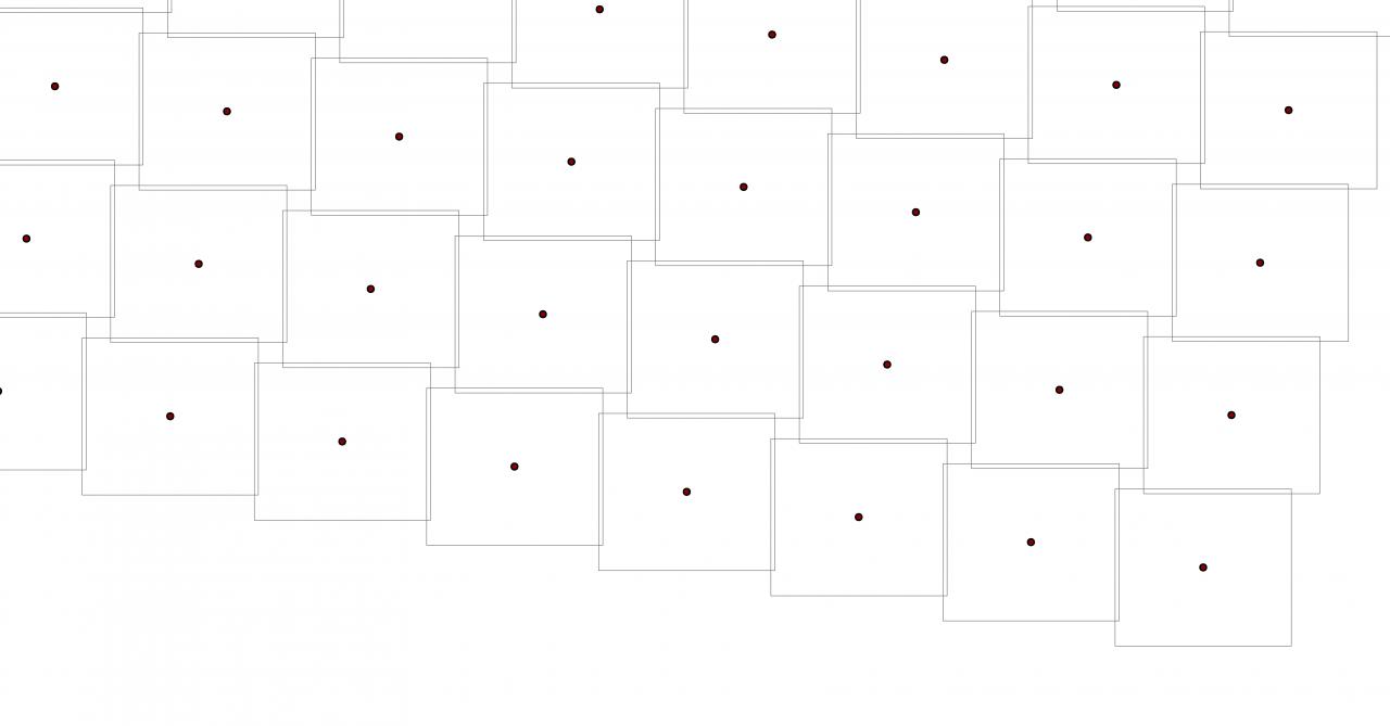
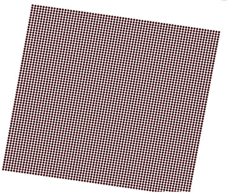
The point features in my dataset are tilted. However, when i create the square buffers around these points, the squares are not tilted accordingly. Thus, this leads to inconsistent square buffers. Can you suggest me something in this regard. I am attaching the image files showing the issue.'
The first image shows the tilted point features and the second image shows the created square buffers that are not tilted.
The method you have suggested has solved the issue. However, I have another issue.
The point features in my dataset are tilted. However, when i create the square buffers around these points, the squares are not tilted accordingly. Thus, this leads to inconsistent square buffers. Can you suggest me something in this regard. I am attaching the image files showing the issue.'
The first image shows the tilted point features and the second image shows the created square buffers that are not tilted.
05-29-2012
08:12 PM
- Mark as New
- Bookmark
- Subscribe
- Mute
- Subscribe to RSS Feed
- Permalink
Oh, it seems your points are equally spaced in rows and columns; the approach would be different then. Have a look of the Create Fishnet tool:
http://help.arcgis.com/en/arcgisdesktop/10.0/help/index.html#//00170000002q000000
You need to do some work to figure out the precise extents (corner coordinates) based on the corner points plus some offsets. The resulting fishnet will be tilted with the points at centers of the cells.
http://help.arcgis.com/en/arcgisdesktop/10.0/help/index.html#//00170000002q000000
You need to do some work to figure out the precise extents (corner coordinates) based on the corner points plus some offsets. The resulting fishnet will be tilted with the points at centers of the cells.
05-30-2012
02:13 PM
- Mark as New
- Bookmark
- Subscribe
- Mute
- Subscribe to RSS Feed
- Permalink
It is getting difficult to estimate the outer coordinates for the vertexes of the four corner squares so as to use them as extent variables for the fishnet tool.
Is there another way where in I can rotate the squares I have attached earlier about their centroids to align them with the tilt in point features?
Alternatively, is there a way to remove the tilt from the point features, then create the square buffers and add the tilt again?
Is there another way where in I can rotate the squares I have attached earlier about their centroids to align them with the tilt in point features?
Alternatively, is there a way to remove the tilt from the point features, then create the square buffers and add the tilt again?
05-31-2012
01:55 PM
- Mark as New
- Bookmark
- Subscribe
- Mute
- Subscribe to RSS Feed
- Permalink
Ok, try the followign (still assuming points are equally spaced in both row and column directions):
1. Use 0.5 KM distance to produce buffers.
2. If you have ArcGIS 10, run Minimum Bounding Geometry tool (Data Management toolbox - Features toolset) on the buffers, specify RECTANGLE_BY_AREA for geoemtry type and ALL for Group Option. You will get one rectangle around all the buffers.
3. Zoom out so that you see a lot of while area around your points. Run Create Thiessen Polygons tool (Analysis toolbox - Proximity toolset; requiring ArcInfo license) on the points; make sure to set Environment ... - Processing Extents to be "Same as Display". You should get square polygons around points, except at the edges where the polygons fill up the display.
4. Use Clip tool (Analysis toolbox - Extract toolset) to clip the Thiessen polygons by the rectangle from Step 2 above.
Is the result what you need?
If you want to automate the "Zoom out" part of Step 3, you can just set a large extent values, so that the Thiessen polygons go out of the rectangle.
06-01-2012
12:26 PM
- Mark as New
- Bookmark
- Subscribe
- Mute
- Subscribe to RSS Feed
- Permalink
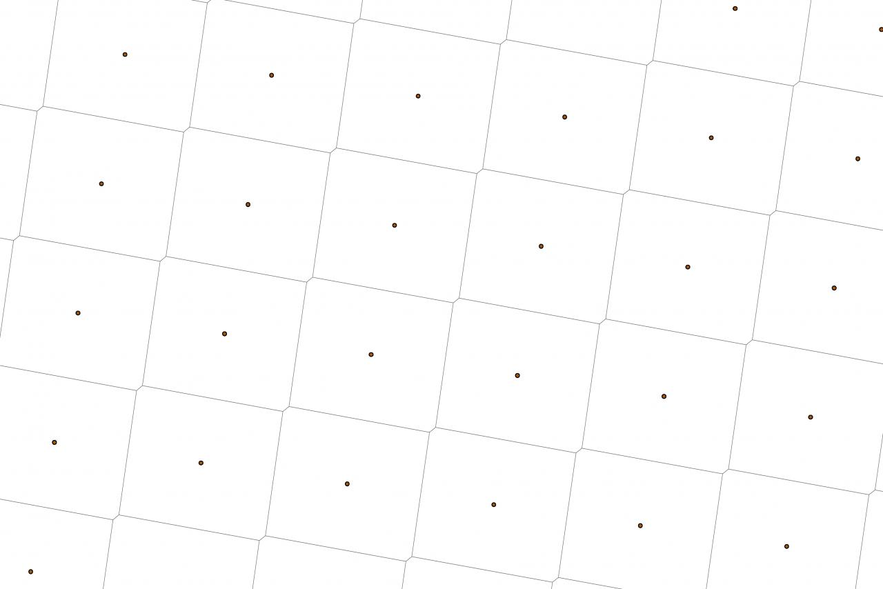
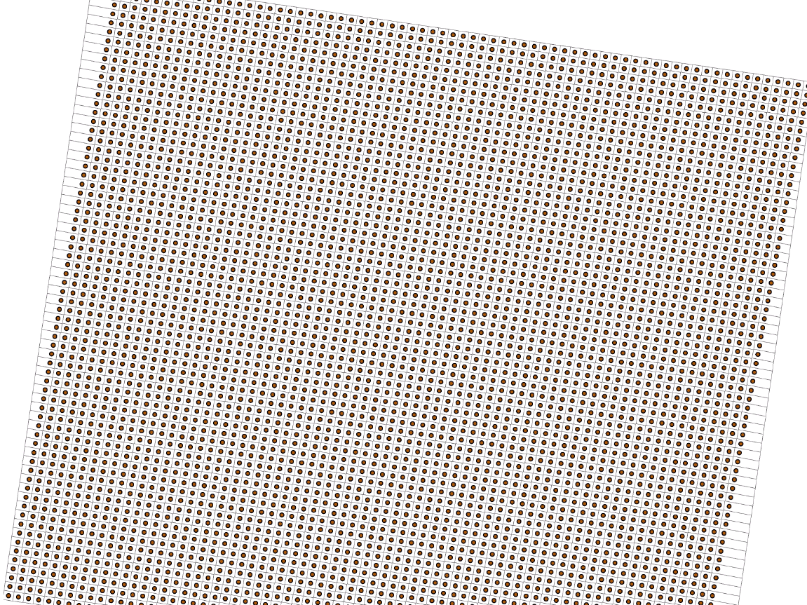
Thanks Dan. This brought me to closest point I want to be. Please have a look at the first image attached. The polygons have tilted along with the points which is what I want.
When I zoomed in, I found that the shapes created using theissen polygons have additional sides at two vertices thus making it a hexagon. Please look at the second picture attached.
Can we do anything about this?
When I zoomed in, I found that the shapes created using theissen polygons have additional sides at two vertices thus making it a hexagon. Please look at the second picture attached.
Can we do anything about this?