Esri Redistricting Blog

cancel
Showing results for 
Show  only  | Search instead for 
Did you mean: 

Other Boards in This Place

Latest Activity

(13 Posts)
ShreeRajagopalan
Esri Regular Contributor

The wait is over! The 2020Census data has been integrated into Esri Redistricting. Read more about new features in the latest release. 

Read more...

more
0 0 610
Mackenzie_OBrien
Esri Contributor

Information on new features added to the latest release of the Redistricting Software

Read more...

more
0 0 1,111
ShreeRajagopalan
Esri Regular Contributor

Discussion around the cyclical process of census - redistricting - precincting - elections.

Read more...

more
3 0 2,052
Mackenzie_OBrien
Esri Contributor

In alignment with the ArcGIS Online Upgrades, the SaaS redistricting offering has undergone a number of upgrades to align with the new functionality.

Read more...

more
0 0 852
ShreeRajagopalan
Esri Regular Contributor

Learn about what's new in Esri Redistricting in this recent December 2020 release.

Read more...

more
0 0 1,557
ShreeRajagopalan
Esri Regular Contributor


If transparency and public engagement are important elements in your community, be sure to watch this recording and learn how Esri Redistricting, a complete software solution for redistricting, can make the redistricting process easier for you.


#Esriredistricting redistricting redistrictingplans #transparency, gerrymandering

more
0 0 1,121
ShreeRajagopalan
Esri Regular Contributor

1. Which browsers are officially supported by the Esri Redistricting software?

Safari, Firefox, MS Edge, and Chrome.  IE 11 will not be supported moving forward.

2. Can I use my own boundary for my Redistricting process, or do I need to use the standard Census data?

  • No, if using the single-seat (SaaS) implementation via ArcGIS online, however you can use your custom data as reference.
  • Yes, if using the on-Premise or Managed Cloud Services version; the data can be customized to fit your redistricting solution as needed.

3. If using a Managed Cloud Services Redistricting solution, what is the standard infrastructure for a single server setup?

  • Standard data storage is up to 500 GB
  • Single cloud ArcGIS Server with 4 virtual computing units and 32 GB of Virtual memory
  • Hosting period 12 months
  • Up to 100 active users
  • Target system availability = 95%
  • Full weekly backups (incremental daily backups)
  • Long term backup for 30 days
  • Daily syncs with your data into your Cloud instance
  • Microsoft Windows Server 2016 (or newer) operating system
  • ArcGIS Enterprise licensing
  • System Monitoring 24/7 with Esri COTS hosted software
  • Operation support 24/7 from MCS

4. What is the advantage of using Esri redistricting solution vs. competitor software?

  • Esri's Redistricting solution is a web-based solution that requires no software installation and is scale-able based on total users.
  • Esri’s Enterprise Redistricting solution allows public participation in the redistricting process to ensure full transparency to the public.

5. Can a "Plan Population" summary report be exported to CSV or other formats for additional analysis? 

  • There is not an "export to CSV" option; however, you can export to an Excel file, then "Save as" CSV".
  • Other export formats are available such as HTML, PDF, and Excel files. 

6. Can all plans be exported to shapefile and block equivalency files all at once?

  • No, there is no bulk export of shapefiles or block equivalency files function.
  • Only single exports of each redistricting plan are available currently. 

7. Can I use my existing ArcGIS Online account for the Redistricting trial software?

  • No. To use the free 21-day trial, you need to create a new ArcGIS Online account using the activation email you receive after submitting the form.
  • If you want to use an existing ArcGIS Online account, please reach out to your Esri Account Manager and/or customer service representative and request to activate a Redistricting evaluation and provision licenses to the app via ArcGIS Online.

8. What is the difference between the free Districting for ArcGIS ArcMap extension vs. the Esri Redistricting SaaS option? 

Districting for ArcGIS

Esri Redistricting SaaS version

Requires ArcMap

Up-to-date web browser

Not menu driven – no UI

Robust UI specifically for political redistricting.

Does not ship with Census P.L. data

Comes with past and current P.L. 94-171 data

Required GIS background and experience

GIS experience not required

Can work with other polygon data, such as work zones, school attendance zones, Police Beats.

Is locked to P.L. data.  Can create other districts but only based on Census geography.

Free, but requires ArcMap

SaaS pricing = $4,500

Users must provide their own data to complete a district plan or boundary

Access to Esri Living Atlas and ArcGIS Online via Esri Redistricting app

No Esri support or active product development

SaaS version has Esri support included


9. Does Esri Redistricting handle a large number of users if my jurisdiction requires public participation (ex: 2000 users)?   

The foundation of Esri Redistricting resides upon ArcGIS Enterprise. The Esri Redistricting solution was designed such that the browser client does most of the heavy lifting which reduces the load on the ArcGIS Server in the background. Because of this, the Esri Redistricting application won't be the bottleneck in the system architecture. If there is concern over the number of users accessing the software, it may be suggested that an additional 4-core server be included to allow your system to auto-scale if necessary.

#esri redistricting#redistricting#gerrymandering#transparency

more
0 0 1,388
ShreeRajagopalan
Esri Regular Contributor

If transparency and public engagement are important elements in your community, be sure to sign up for the upcoming webinar and learn how Esri Redistricting, a complete software solution for redistricting, can make the redistricting process easier for you.

Webinar title: Delivering a Modern Redistricting Solution

Webinar date: October 28, 2020 | 10 am - 11 am PDT

Sign up here


#Esriredistricting redistricting redistrictingplans #transparency, gerrymandering

more
1 0 757
NickGiordano
New Contributor III

For those of you interested in trying out the Esri Redistricting application, you can head over to the Free Trial page and fill out the "Try Esri Redistricting" form to get access to a trial of ArcGIS Online, which includes licensing for Esri Redistricting. Below is a walk-through of the trial process:

  1. Fill out the form on the Redistricting Free trial page to request a trial of ArcGIS Online and Esri Redistricting. After completing and submitting form, a confirmation appears on the page and activation link is sent to email provided in the form.

  2. Go to your inbox for the email that you provided in the form, and find the activation email that was sent from Esri. Click-through the activation link in that email.

  3. Create your ArcGIS Online account by filling out the account creation form. After finishing and clicking the "create my account" button, you should be redirected to the organizational setup page (below), as well as receive another email confirming your ArcGIS Online account is now set up. Finish filling out that organizational details page and hit "Save and Continue."

  4. Now that your organization is setup, you can close out of the modal that pops up (below) and navigate to the "Licenses" section of the "Organization" page. Then scroll down to "Redistricting Online" and hit the 'manage' button.


  5. In the "Manage: Redistricting Online" pop-up window, you will have 2 Redistricting app licenses to give to your organizational accounts. Turn on licenses for accounts that need access to Redistricting by selecting the switch to the right of the users name so that the color turns from grey to blue (as shown below). An optional pop-up will also appear asking if you want to email the member about the new license. 

  6. Now your accounts should see "Redistricting Online" in the app launcher tray at the top-right of the screen, as shown below. Select the Redistricting Online icon to launch Esri Redistricting (or navigate to the page directly via this link: Esri Redistricting Online 


  7. Now select "Sign in to ArcGIS.com" and enter the ArcGIS Online username and password you've created, select "Agree" on the Licensing agreement pop-up, and you can begin to use your Esri Redistricting trial.

more
0 0 703
ShreeRajagopalan
Esri Regular Contributor

Esri provides software and services needed to help you set up Esri Redistricting and develop your staff capabilities. Several options are available for delivering the necessary enablement services through implementation services and technical knowledge transfer.


Esri Redistricting can be deployed in three ways depending on your organization’s needs. For each deployment option, you can request additional days of onsite training and knowledge transfer for your organization. Note that, the implementation approach provided below can be adjusted to meet your specific needs.


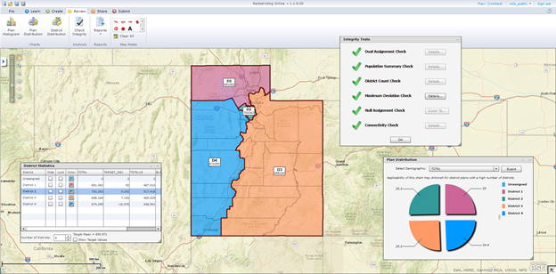
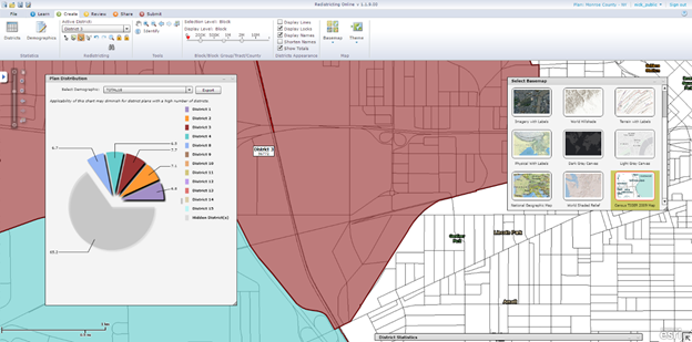
     The Esri Redistricting application includes a host of integrity checks and reports for analyzing potential redistricting plans


Option 1: Software‐as‐a‐Service (SaaS)


When you deploy Esri Redistricting as a SaaS solution, you can access Esri Redistricting in the cloud, entirely hosted and maintained by Esri. You don’t need to install or maintain any software or hardware—instead, you simply log in to your ArcGIS account in a web browser. The SaaS option provides access to all functionality of the solution, including the default Census demographic data, geographies, and the ability to add content from accessible ArcGIS web services. 


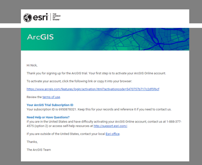
The SaaS version of Esri Redistricting is available for purchase on a per-user basis from ArcGIS Marketplace with a 15-day free trial option.


 Option 2: On‐Premises Deployment


With this option, Esri Redistricting is hosted at your facility, giving you the flexibility to integrate custom variables, units, or demographics. Prior to arriving onsite, Esri Professional Services experts will work with your team to pre-configure appropriate Census data, your custom data, and other configuration parameters. Once onsite, our experts will install and configure the solution stack on your infrastructure, conduct a technology transfer for administrators who are qualified to manage the Esri Redistricting application, and help facilitate ongoing support and maintenance of the solution.


The instance will be hosted and managed by you. You have full control over adding users, customizing the solution, and managing the application. This option also enables you to engage your community by allowing citizens to submit redistricting plans (read about how Utah State Legislature utilized Esri Redistricting to add citizen input into their redistricting process).

 
You will provide the first point of contact (Tier 1 helpdesk support) to your end users to address any operational use or technical issues with Esri Redistricting. This support consists of answering user questions, replicating and reviewing reported issues, addressing solution use or training requirements (if appropriate), and documenting and communicating validated technical issues to Esri technical support staff (Tier 2 support).

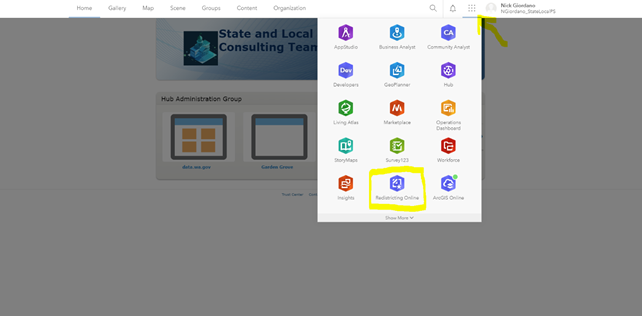
      Esri Redistricting utilizes the trusted ArcGIS platform allowing you to leverage existing GIS investments


Option 3: Esri Managed Cloud Services Deployment (Managed Services)


This deployment option offers Esri Managed Cloud Services for customers who do not have IT staff that are experienced in supporting enterprise GIS systems. The solution is completely web-based and does not require you to manage or maintain infrastructure and resources including software, hardware, and data components.


Esri’s Managed Cloud Services team will create, host and manage an instance of Esri Redistricting for you, configured with the appropriate Census data, your custom data, and other configuration parameters. The instance will provide external HTTP access to Esri Redistricting, operational hosting and monitoring, and troubleshooting for technical support incidents through Tier 2 hosted environment support.


This deployment option will address the following service level targets to support your operational requirements:


  1.       24x7 system access
  2.       95% system availability
  3.       Hosting environment to support up to 20 concurrent users
  4.       Up to 500 GB of custom data storage
  5.       Data backup and archive
  6.       Annual update of custom data
  7.       24x7 system monitoring and Tier 2 hosted environment support 


You will provide the first point of contact (Tier 1 helpdesk support) to your end users to address any operational use or technical issues with Esri Redistricting. This support consists of answering user questions, replicating and reviewing reported issues, addressing solution use or training requirements (if appropriate), and documenting and communicating validated technical issues to Esri technical support staff (Tier 2 hosted environment support).


Interested in Esri Redistricting? Comment below and we will get in touch with you.


more
0 1 3,022
59 Subscribers