- Home
- :
- All Communities
- :
- Industries
- :
- Education
- :
- Education Blog
- :
- Track on Track: A Spatial Resolution Experiment
Track on Track: A Spatial Resolution Experiment
- Subscribe to RSS Feed
- Mark as New
- Mark as Read
- Bookmark
- Subscribe
- Printer Friendly Page
Perhaps this experiment that I conducted 4 years apart will be useful for all those teaching GIS and teaching with GIS, on the topics of GIS, GPS, and spatial resolution:
Track on Track, Revisited: Spatial Accuracy of Field Data | Spatial Reserves
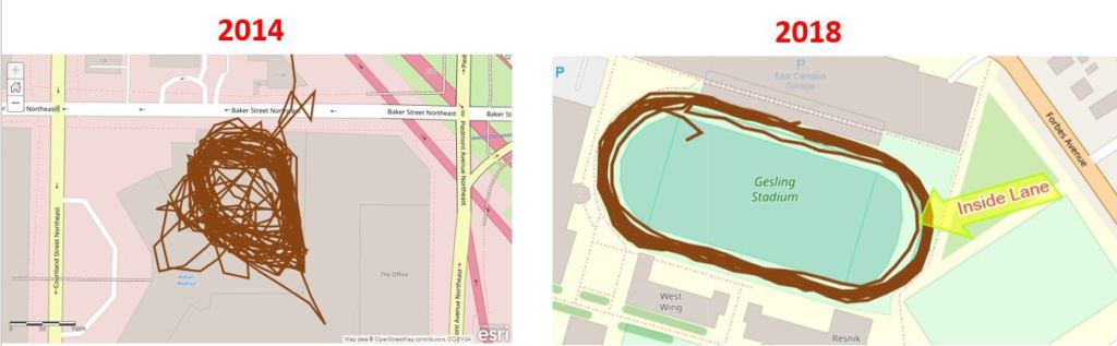
Track from 2014 (left) and 2018 (right) gathered from a smartphone and a fitness app.
Back in 2014, I tested the accuracy of smartphone positional accuracy in a small tight area by walking around a tr.... During a recent visit to teach GIS workshops at Carnegie Mellon University, I decided to re-test, again on a running track. My hypothesis was that triangulation off of wi-fi hotspots, cell phone towers, and the improved GPS constellation would have improved the spatial accuracy of my resulting track over those intervening years.
After an hour of walking, and collecting the track on my smartphone with a fitness app (Runkeeper), I uploaded my track as a GPX file and created a web map showing it in ArcGIS Online. Open this map > use bookmarks > navigate to the Atlanta and Pittsburgh (Carnegie Mellon University) locations (also shown on the graphic below on the left and right, respectively). Once I mapped my data, my hypothesis was confirmed: I kept to the same lane on the running track, and the width of the resulting lines averaged about 5 meters, as opposed to 15 meters on the track from four years ago. True, the 2014 track variability was no doubt in part because I was surrounded by tall buildings on three sides (as you can see in my video that I recorded at the same time) , while the building heights on the Carnegie Mellon campus were much lower. However, you can measure for yourself on the ArcGIS Online map linked above and see the improvement over those two tracks taken just 4 years apart.
I did another test while at Carnegie Mellon University–during my last lap on the track, I moved to the inside lane. This was 5 meters inside the next-to-outer lane where I completed my other laps. I wanted to see whether this shift would be visible on the resulting map. It is! The lane is clearly visible on the map and on the right side of the graphic below, marked as “inside lane.”
To explore further, on the map above, go to > Contents, to the left of the map, and turn on the World Imagery Clarity layer. Then use the Measure tool to determine how close the track is to the satellite imagery (which isn’t perfect either, but see teachable moments link below). You will find that at times the track was 0.5 meters from the image underneath Lane 1, and at other times 3.5 meters away.
Both tracks featured “zingers” – lines stretching away from the actual walking tracks, resulting from points dropped as I exited the nearby buildings and walked outside, as my location based service first got its bearing. But again, an improvement was seen: The initial point was 114 meters off in 2014, but in 2018, only 21.5 meters. In both cases, as I remained outside, the points became more accurate. When you collect data, the more time you spend on the point you are collecting, typically the more spatially accurate that point is.
To dig deeper into issues of GPS track accuracy and precision, see my related essay on errors and teachable moments in collecting data, and on comparing the accuracy of GPS receivers and smartphones and mapping field collected data in ArcGIS Online here and here.
Location based services on the smartphone still do not yet deliver the spatial accuracy for laying fiber optic cable or determining differences in closely-spaced headstones in cemeteries (unless a device such as Bad Elf or a survey-grade GPS is used). Article are appearing that predict spatial accuracy improvements in smartphones. Even today, though, I was quite pleased with my track’s spatial accuracy, particularly in 2018. I was even more pleased considering that I had the phone in my pocket most of the time I was walking. I did this in part because it was cold, and cold temperatures tend to rapidly deplete my cell phone’s battery (which is unfortunate, and the subject of other posts, many of which sport numerous adds, so they are not listed here). Happy field data collection and mapping!
--Joseph Kerski
You must be a registered user to add a comment. If you've already registered, sign in. Otherwise, register and sign in.
-
Administration
89 -
Announcements
85 -
Career & Tech Ed
1 -
Curriculum-Learning Resources
280 -
Education Facilities
24 -
Events
77 -
GeoInquiries
1 -
Higher Education
616 -
Informal Education
284 -
Licensing Best Practices
102 -
National Geographic MapMaker
39 -
Pedagogy and Education Theory
239 -
Schools (K - 12)
282 -
Schools (K-12)
302 -
Spatial data
39 -
STEM
3 -
Students - Higher Education
257 -
Students - K-12 Schools
142 -
Success Stories
44 -
TeacherDesk
1 -
Tech Tips
125
- « Previous
- Next »