- Home
- :
- All Communities
- :
- Industries
- :
- Education
- :
- Education Blog
- :
- Teaching with the Green Infrastructure Tools
Teaching with the Green Infrastructure Tools
- Subscribe to RSS Feed
- Mark as New
- Mark as Read
- Bookmark
- Subscribe
- Printer Friendly Page
Helping students think spatially is a key goal for many of us involved in GIS education work, and the growing set of resources, data, and tools in the Green Infrastructure initiative can help students reach that goal. These resources (http://www.esri.com/about-esri/greeninfrastructure) are aimed at helping communities to preserve and connect open spaces, watersheds, wildlife habitats, parks, and other critical landscapes. One way to open the discussion with students is to use the "How Green Is Your Community" tool on the page. Entering their zip code into the Current tab results in a map and a set of graphs describing rivers, land cover, agriculture, and other themes, where students can compare their own community to local, state, and national averages for those same themes. Entering the same zip code or address in the Future tab shows how land cover is predicted to change between 2011 and 2050 via a swipe map that can be examined at multiple scales.
Another activity you can engage students in helps them think about the themes that planners use as they seek to build a sustainable future. By accessing the "landscape cores" interactive map, students can examine a variety of themes that they may not have thought about before, but are critical to everyday planning, such as land ownership, soils suitable for agriculture, and my favorite, the Theobald Human Modified Surface, which indicates the degree to which humans have modified the landscape. Each layer's opacity can be changed and the scale and region can be altered to examine local areas of ones across the country. And in keeping with our focus on fostering critical thinking about the data, each data layer can be investigated so that students know what each one means, who created it, and how it was created.
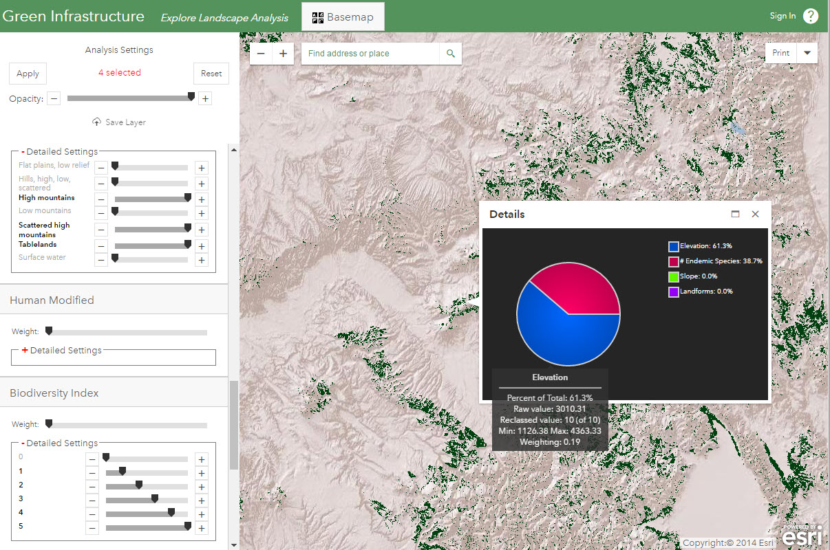
Another resource that students can use is the set of Advanced Apps for Green Infrastructure Analysis. Let's focus on just one of them, the "Conduct Landscape Analysis" app. With it, students can experiment with weighting different components of land cover scoring. This can help students with working with GIS tools, to see that not only do the themes included in spatial analysis make a difference in the final result, but the weights assigned to each theme also make a big difference. In the example below, I set up a scenario where I want to study areas that are high in elevation, are flat or nearly so, and have a high number of endemic species. On my map I see the areas meeting those criteria in western Colorado along with popups that provide further information, and I can easily adjust the weights and themes to see the difference those adjustments make spatially.
Want more? Students can use all of the apps on the page with their ArcGIS Online accounts, to run through a real world problem scenario, choose themes and weights, and save their results to ArcGIS Online. They could even download these results to ArcGIS Pro or GeoPlanner for further analysis. This week, the GeoDesign Summit was held at Esri in Redlands where people gathered to discuss how these tools can be further developed to build and design a sustainable world. Have your students examine the papers given at the Summit and think about the career pathways that are opening up in this field.
You must be a registered user to add a comment. If you've already registered, sign in. Otherwise, register and sign in.
-
Administration
90 -
Announcements
88 -
Career & Tech Ed
1 -
Curriculum-Learning Resources
288 -
Education Facilities
24 -
Events
78 -
GeoInquiries
1 -
Higher Education
620 -
Informal Education
286 -
Licensing Best Practices
102 -
National Geographic MapMaker
44 -
Pedagogy and Education Theory
243 -
Schools (K - 12)
282 -
Schools (K-12)
311 -
Spatial data
40 -
STEM
3 -
Students - Higher Education
261 -
Students - K-12 Schools
149 -
Success Stories
45 -
TeacherDesk
1 -
Tech Tips
130
- « Previous
- Next »