Turn on suggestions
Auto-suggest helps you quickly narrow down your search results by suggesting possible matches as you type.
Cancel
Live Maps, Live Cameras
Subscribe
3807
7
12-26-2013 09:55 PM
- Subscribe to RSS Feed
- Mark as New
- Mark as Read
- Bookmark
- Subscribe
- Printer Friendly Page
12-26-2013
09:55 PM
If you are a reader of this blog and are an advocate of the use of GIS in education, it should be obvious by now that live web maps, many of which are powered by ArcGIS Online, are all around us. They can be used in a variety of ways to enhance teaching and learning. But did you also know that an expanding number of them are tied to live webcams? The examples below represent a small fraction of these; I encourage you to share your own favorites by commenting on this blog.
I created storymaps of Bruges, Belgium, and the Front Range of Colorado. In each map, select the webcams tab to examine such places as The Markt and the foothills near Golden to teach about current weather, landforms, land use, climate, cultural diversity, vegetation, and more.
The following maps were created by my colleague here at Esri, Matt Artz, who runs his own excellent blog on GIS and science.
You can use the Oregon State University's Facilities Dashboard to see what's happening on campus, but also for inspiration for the storymaps that you might build for your own campus.
Use the US Centers for Disease Control and Prevention (CDC) Health Advisories by Country live web map as a useful resource in planning your next trip, but also for a good model on how to build a storymap with thumbnail maps and web sites instead of photographs.
Use the Owens Valley Live Dustcams storymap to teach about landforms, climate, current weather, and the influence of human activity and natural conditions on air quality. You could do something similar for a larger region using The High Sierra web map, which features webcams pointing at highways and even ski runs! Or, to examine ecoregions, vegetation, climate, land use, and landforms of some of the most spectacular areas of the entire USA, use this live web map of The National Parks (shown below).
Monitor headlines around the world with this storymap linked to current headlines of newspapers, and consider why certain regions' newspapers have the headlines they do, and which stories are common to multiple locations.
One of my favorite maps gives you the ability to monitor current conditions of oceans and ports using the Our Oceans storymap. Or, use the Volcanoes of the World story map as part of your unit on investigating different types of volcanoes, where they exist, and the threats they pose.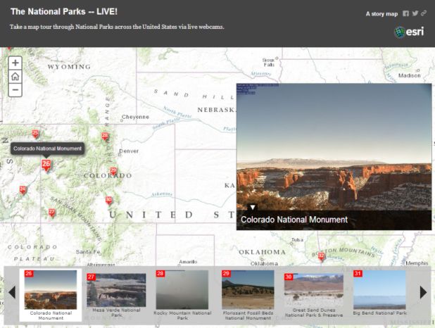
What could you do with these and other live web maps linked to webcams?
I created storymaps of Bruges, Belgium, and the Front Range of Colorado. In each map, select the webcams tab to examine such places as The Markt and the foothills near Golden to teach about current weather, landforms, land use, climate, cultural diversity, vegetation, and more.
The following maps were created by my colleague here at Esri, Matt Artz, who runs his own excellent blog on GIS and science.
You can use the Oregon State University's Facilities Dashboard to see what's happening on campus, but also for inspiration for the storymaps that you might build for your own campus.
Use the US Centers for Disease Control and Prevention (CDC) Health Advisories by Country live web map as a useful resource in planning your next trip, but also for a good model on how to build a storymap with thumbnail maps and web sites instead of photographs.
Use the Owens Valley Live Dustcams storymap to teach about landforms, climate, current weather, and the influence of human activity and natural conditions on air quality. You could do something similar for a larger region using The High Sierra web map, which features webcams pointing at highways and even ski runs! Or, to examine ecoregions, vegetation, climate, land use, and landforms of some of the most spectacular areas of the entire USA, use this live web map of The National Parks (shown below).
Monitor headlines around the world with this storymap linked to current headlines of newspapers, and consider why certain regions' newspapers have the headlines they do, and which stories are common to multiple locations.
One of my favorite maps gives you the ability to monitor current conditions of oceans and ports using the Our Oceans storymap. Or, use the Volcanoes of the World story map as part of your unit on investigating different types of volcanoes, where they exist, and the threats they pose.

The Colorado National Monument from The National Parks story map. One of my all time favorite parks. OK, I'm biased--I spent a lot of time hiking here as a child.
What could you do with these and other live web maps linked to webcams?
7 Comments
You must be a registered user to add a comment. If you've already registered, sign in. Otherwise, register and sign in.
About the Author
I believe that spatial thinking can transform education and society through the application of Geographic Information Systems for instruction, research, administration, and policy.
I hold 3 degrees in Geography, have served at NOAA, the US Census Bureau, and USGS as a cartographer and geographer, and teach a variety of F2F (Face to Face) (including T3G) and online courses. I have authored a variety of books and textbooks about the environment, STEM, GIS, and education. These include "Interpreting Our World", "Essentials of the Environment", "Tribal GIS", "The GIS Guide to Public Domain Data", "International Perspectives on Teaching and Learning with GIS In Secondary Education", "Spatial Mathematics" and others. I write for 2 blogs, 2 monthly podcasts, and a variety of journals, and have created over 6,500 videos on my Our Earth YouTube channel.
Yet, as time passes, the more I realize my own limitations and that this is a lifelong learning endeavor: Thus I actively seek mentors and collaborators.
Labels
-
Administration
89 -
Announcements
86 -
Career & Tech Ed
1 -
Curriculum-Learning Resources
284 -
Education Facilities
24 -
Events
77 -
GeoInquiries
1 -
Higher Education
618 -
Informal Education
285 -
Licensing Best Practices
102 -
National Geographic MapMaker
41 -
Pedagogy and Education Theory
240 -
Schools (K - 12)
282 -
Schools (K-12)
305 -
Spatial data
39 -
STEM
3 -
Students - Higher Education
258 -
Students - K-12 Schools
144 -
Success Stories
44 -
TeacherDesk
1 -
Tech Tips
127
- « Previous
- Next »