- Home
- :
- All Communities
- :
- Industries
- :
- Education
- :
- Education Blog
- :
- Fun with GIS 274: Minnesota Model
Fun with GIS 274: Minnesota Model
- Subscribe to RSS Feed
- Mark as New
- Mark as Read
- Bookmark
- Subscribe
- Printer Friendly Page
"What builds successful use of GIS in schools across a state? What leads to widespread use of a technology not built for schools? Is there a model that other states could follow?" people ask when contemplating GIS in schools. Depending on the questions, I may point to several states, but one is always Minnesota.
Full disclosure: I am a native Minnesotan, with 50 years in the state, including half my Esri career. But I have traveled a lot, and lived half my Esri time in California and the DC area. This is not simply "home bias." I want to find (or catalyze) such success everywhere.
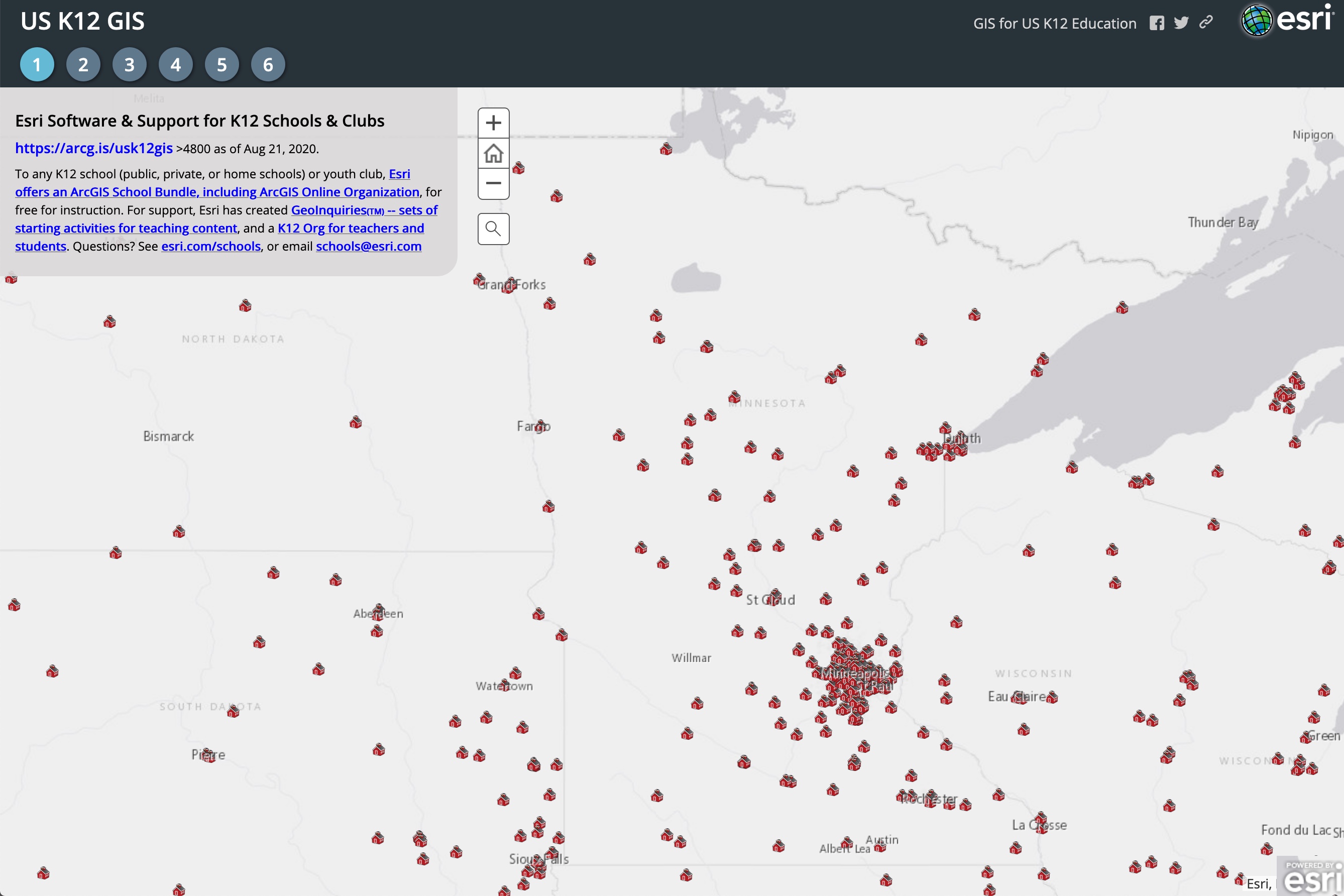
The map of ArcGIS School Bundles across USA shows one story. The data behind it show more. Minnesota has a high rate of licenses per 100 schools, a high "activation" rate (launching the ArcGIS Online Org), and high numbers of users per Org. Minnesota launched a state-wide competition in 2016, which became the model for Esri's ArcGIS Online Competition for US High School and Middle School Students, and MN has consistently had the highest participation, plus national winners in the first three years (2017, 2018, 2019; national winners were not declared in 2020 due to the pandemic). Minnesota has run teacher training events for decades that included GIS components and, since 2014, dozens of events for teachers specifically to learn to use GIS. Indicators of success abound.
Why? How? Who's doing all this? It's a network, a culture, decades in development. In 1985, Macalester College geography professor David Lanegran began holding summer institutes for geography teachers. I was a participant in 1986, and learned there from middle school teacher Jim Hanson to use database-driven inquiry-oriented investigations with students on Apple IIe computers. In 1987, the Minnesota Alliance for Geographic Education (MAGE) launched, as part of a network organized by National Geographic, and began influencing generations of teachers. Dozens of institutes and countless workshops later, MAGE is still a force, with Lanegran and Hanson (both despite being formally retired) and a host of others still vigorously promoting geographic thinking, analysis, and technology to teachers. Presciently, their 2019 summer institute was conducted online.
Across USA, "Advanced Placement Human Geography" started in 2001, and 9th grade quickly became a key target; many schools in Minnesota (featuring MAGE-trained teachers) offered APHG, building skills in thinking geographically. The sciences, too, have engaged decades of students, from elementary school on up, in projects that relied on data gathering and analysis, whether about local butterflies, migratory birds, regional water quality, budding plants, faraway whales, global temperature patterns, or the very local ways in which humans can prepare for fires.
Meanwhile, the Minnesota Department of Education (MDE) hosted a statewide license of Esri software for school instruction. Working with content teams, MDE incorporated GIS formally into some state educational standards. While such standards do not dictate the exact content or style of instruction, good teachers easily find support for the critical thinking skills, problem solving, integration of knowledge, and active learning that are hallmarks of GIS. "There is legitimacy in GIS for teachers just because it is in the state standards," said MAGE co-coordinator Kelly Swanson, who teaches at both Johnson High School and Metropolitan State University.
MDE is also a key communicator to schools, districts, leaders, and teachers about opportunities to learn about using GIS in all areas. But the biggest influencer at MDE was their GIS lead (recently retired), Scott Freburg. A longtime desktop GIS user with deep ties to MN GIS/LIS -- the state's professional GIS community -- Freburg recognized the power of online GIS for instruction, and encouraged the pros to support teachers with events and dollars. Dozens of GIS users led scores of events introducing hundreds of teachers, starting in 2014. They launched a "GIS for Educators Day" in the fall. To make sure teachers could attend, they provide funding for transportation and even for substitute teachers. This annual event features teachers and students as lunchtime speakers, teachers and GIS users mixing at tables, with users offering data and tips, leading to long-term mentorships or serving as competition judges. Coordinator of Ed for U-Spatial@UMD, Stacey Stark, said "What has finally happened this year is that the presentations are being done by teachers, not by those of us who live in this field." Freburg added "This has been our goal for years -- for the teachers to lead it." And it all makes a difference. "Seeing Educators Day was important for me; seeing it every year after that made it clear to our department that this is a big deal. This will be our fifth year of 7 teachers from high school and middle school attending," said Sauk Rapids Rice High School geography teacher Brianne Wegter. Minnesota's Chief Geospatial Information Officer Dan Ross has supported GIS Educators Day with his imprimatur, and more: "It is very important for the state office and community to support teachers in our pursuit of geography and building the next generation of geographers and geospatial professionals." All this helps teachers secure time -- that most precious gift -- to learn, share, and be inspired, even if just meeting online this year.
Each building block leads to teachers introducing GIS to kids who get inspired to do impressive work. Of the national prizes in Esri's competition, half have gone to students in Minnesota. "We love the competition as a good culminating event," Wegter said. "We have all our 9th grade students do it -- just over 350 kids this past year. They create a map, and some do it in partnership, so we had just over 250 entries to the competition. It gives teachers a way to bring these skills and data together; it guides us all year long." Hanson added a different spin: "I pull all the state's entries together for the judges, and the frustrating thing to me -- and it happens every year -- is seeing a kid with a brilliant idea, but who didn't really have the support from a GIS perspective to bring it to life. We need even more connection to mentors."
Minnesota's success has not come from solo work by a digital version of giant lumberjack Paul Bunyan. It is from a large group of people at many different organizations seeing a key opportunity and working together. Numerous other leaders and teachers deserve mention above for their role. Truly, any state can do this.
You must be a registered user to add a comment. If you've already registered, sign in. Otherwise, register and sign in.
-
Administration
90 -
Announcements
88 -
Career & Tech Ed
1 -
Curriculum-Learning Resources
286 -
Education Facilities
24 -
Events
77 -
GeoInquiries
1 -
Higher Education
618 -
Informal Education
286 -
Licensing Best Practices
102 -
National Geographic MapMaker
43 -
Pedagogy and Education Theory
241 -
Schools (K - 12)
282 -
Schools (K-12)
308 -
Spatial data
39 -
STEM
3 -
Students - Higher Education
259 -
Students - K-12 Schools
147 -
Success Stories
44 -
TeacherDesk
1 -
Tech Tips
129
- « Previous
- Next »