- Home
- :
- All Communities
- :
- Industries
- :
- Education
- :
- Education Blog
- :
- Cool Drone...What Do We Do With It?
Cool Drone...What Do We Do With It?
- Subscribe to RSS Feed
- Mark as New
- Mark as Read
- Bookmark
- Subscribe
- Printer Friendly Page
We can all agree, drones are pretty cool. Yet, as the 'ooo's' and 'aahhh's' start to diminish after you pull it out of the box, people start to wonder how it can provide value to your organization.
Just west of LA, is an area called the Cajon Pass and it plays a critical role in Southern California. Not only does a major rail corridor and interstate travel through the pass, but there are some major transmission lines travelling through as well. Just last year (2016), there was a big wildfire (Blue Cut Fire) that ended up burning 37,000 acres. The interstate ended up getting closed, rail was impacted, and the fire burned right under 500 kVa conductor. The fire was incredibly disruptive, but could have been even more so if any of the transmission lines had been taken out.
So, a few of us decided to take a road trip over to a small section of the Cajon Pass that didn't burn during the fire, which would provide a chance to see how vegetation could impact the transmission line in a future fire. Along with monitoring the vegetation, we wanted to accomplish a couple of things:
- Conduct tower inspections in the field using Drone2Map
- Build out orthomosaics to show the right of way (ROW)
- Create point clouds of the transmission towers
- Determine where vegetation could threaten the conductor
The goal was also to accomplish all of this with out of the box Esri tools. Recent software releases from Esri now provide customers with the ability to process, analyze, share, and view ortrhomosaics, point clouds, and inspections within core software.
Inspections
The first flight that we conducted was a free flight, to capture some of the detail on the transmission tower. We wanted to see how a drone could be used to get more detail than conducting a ground based visual inspection.
One of the cool things about Drone2Map, is the ability to use it as a field application. After landing the drone, we pulled out the SD card and started a new 'Inspection' project in Drone2Map.
Drone2Map takes a few minutes to pull in all of the imagery, builds out the flights lines, and places all of this over the World Imagery Service provided by Esri. There is also an inspection viewer that opens up to let users see the detail in their photos.
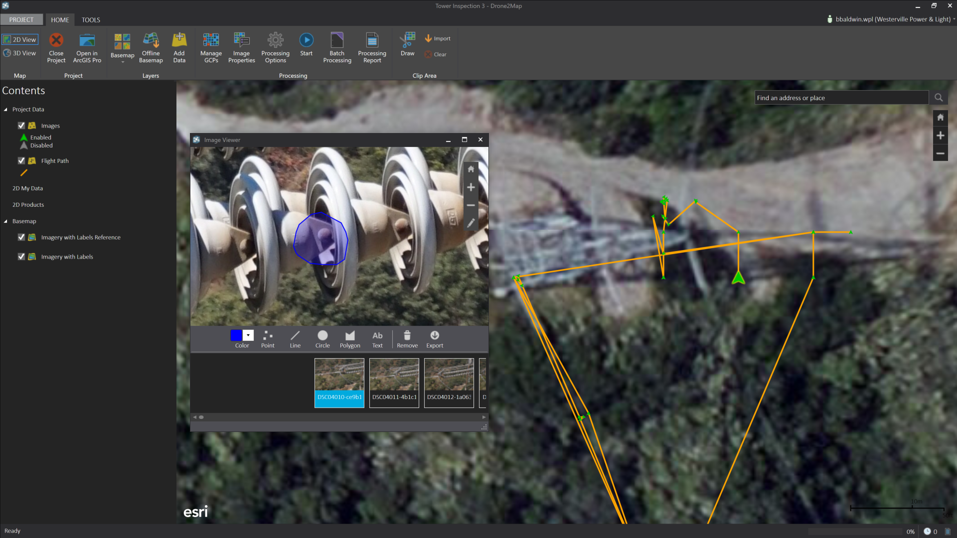 Includes the ability to create mark-up on the photos
From the ground, it would have been impossible to discern whether there were any occupants in the couple of nests that were located on the tower. Using Drone2Map in the field would have been a great way to capture avian protection information.

Ca-Caw!
Imagery
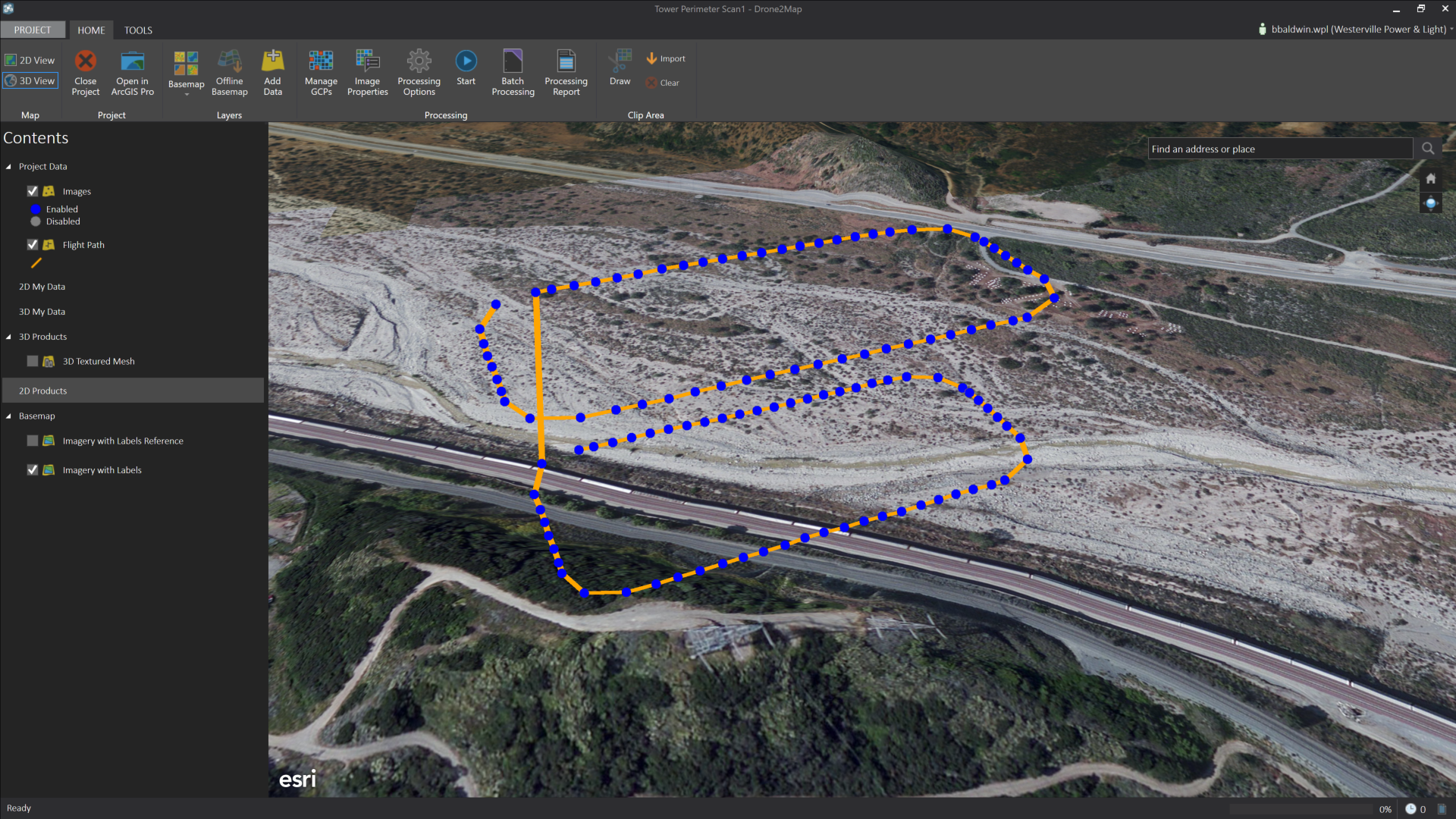
The next flight we conducted, was a grid. We wanted to capture photos shooting straight down at the ground, while flying over the conductor and towers. This would help us build out orthomosaics and some 3D datasets. Drone2Map provides a couple different options for how a user can build out their imagery and also provides a rapid setting so that you can see how your coverage looks while in the field. Rather then running the rapid mode, we ended up processing our imagery back in the office, so that I could build out all of the output options (DTM, DSM, and imagery).

Flight paths, with ArcGIS Online World Imagery

Flight paths with an orthomosaic processed in Drone2Map
While Drone2Map stitches together the images to build orthomosaics, it also builds a point cloud from the imagery, which is used to create the DSM and DTM. While the point cloud is not displayed in Drone2Map, users can take that LAS output and bring it into other applications (ArcGIS Pro).
Point Clouds
From the previous flight, Drone2Map built out an unclassified point cloud which we will use in ArcGIS Pro in a minute. But, we also wanted to conduct a 3rd flight that orbited just the towers, to see what kind of visualization we could build out for the structures.
Orbit flight path
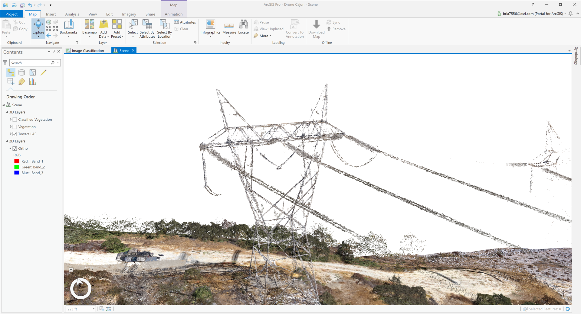
Point cloud from the orbit flight in ArcGIS Pro
I also just want to make sure everyone is clear that this point cloud was not collected via a Lidar scan or with a Lidar sensor, this is built from the imagery that was flown.
Vegetation
Lastly, we wanted to take some of the data that was built out using Drone2Map and use ArcGIS Pro to determine the impact that vegetation could have on the conductor.
By using the orthomosaic that Drone2Map built out, we can use the imagery tools in ArcGIS Pro to segment and classify the imagery. This segmented image can then be used to classify our point cloud. So, now we know where all of the vegetation is...
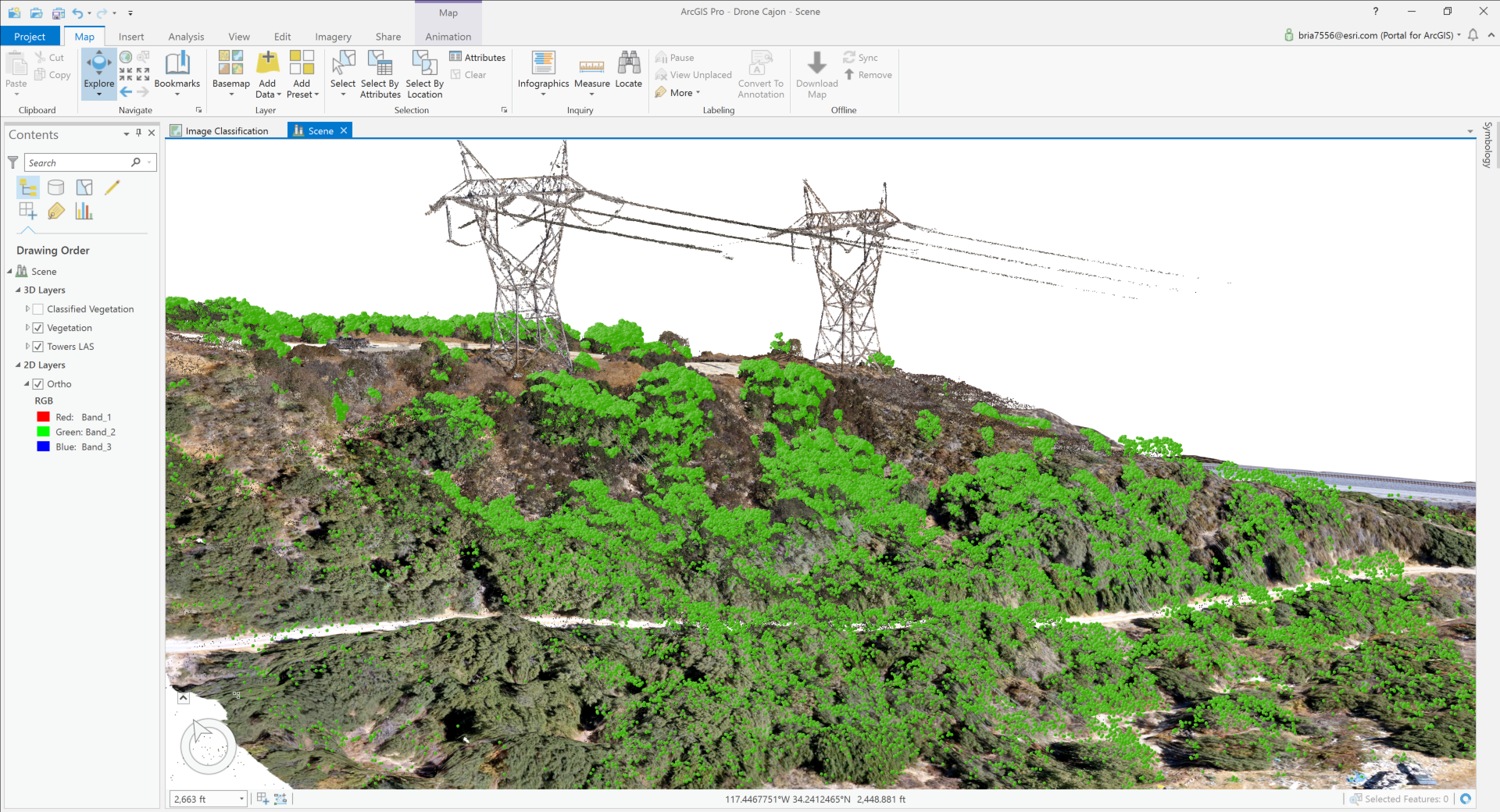
Then, we can use the 3D Analyst tools in ArcGIS Pro to see what actual vegetation is within a certain distance of our conductor.

Close
While drones are really cool, there are a number of great applications for there use in the utility space. In just one short morning, we were able to conduct field inspections, build orthomosaics, and create 3D data for both visualization and vegetation management.
Recent software releases from Esri now provide customers with the ability to process, analyze, share, and view ortrhomosaics, point clouds, and inspections within core software.
Lastly, all of these outputs can now be shared to the web via ArcGIS Online or Portal! So, any of the point clouds or imagery that you produce can be shared with users across your organization.
You must be a registered user to add a comment. If you've already registered, sign in. Otherwise, register and sign in.
-
Administration
91 -
Announcements
88 -
Career & Tech Ed
1 -
Curriculum-Learning Resources
289 -
Education Facilities
24 -
Events
78 -
GeoInquiries
1 -
Higher Education
621 -
Informal Education
287 -
Licensing Best Practices
104 -
National Geographic MapMaker
44 -
Pedagogy and Education Theory
245 -
Schools (K - 12)
282 -
Schools (K-12)
313 -
Spatial data
40 -
STEM
3 -
Students - Higher Education
261 -
Students - K-12 Schools
150 -
Success Stories
46 -
TeacherDesk
1 -
Tech Tips
130
- « Previous
- Next »