- Home
- :
- All Communities
- :
- Events
- :
- DevSummit Conference
- :
- DevSummit Conference Documents
- :
- 2020 DevSummit: Your Guide to the Plenary & Relate...
- Subscribe to RSS Feed
- Mark as New
- Mark as Read
- Bookmark
- Subscribe
- Printer Friendly Page
2020 DevSummit: Your Guide to the Plenary & Related Technical Sessions Videos
2020 DevSummit: Your Guide to the Plenary & Related Technical Sessions Videos
DevSummit 2020 rapidly moved to a virtual event in March as a result of the coronavirus epidemic. To get you caught up on the virtual experience, here is a recap of the Plenary and related technical sessions from the 2020 Dev Summit to check out. This guide will be updated as videos are uploaded with related sessions only.
See a full list of Dev Summit 2020 videos here.
Get in the DevSummit spirit: Watch this version of the See What Others Can’t commercial that kicked off the Plenary. This version was made just for developers. Watch: Live By the Code
 Following some brief comments from Jack, Jim McKinney, Chief Technical Officer of ArcGIS Desktop, takes a moment to acknowledge that this fifteenth annual summit is “for developers by developers.” He encourages viewers to engage with the community with the following resources that are available all year long:
Online Community: GIS developers identify GeoNet as the number one place where developers talk and connect. If you’re not registered, Register to become a new member.
Tech Workshops: Session recordings are uploading to Esri Events on YouTube.
Pre-Conference Hands-on Workshops will be converted into live webinars or MOOCs: esri.com/GeoDev
Watch: Welcome to DevSummit
- ArcGIS: A Platform for Developers
- ArcGIS Platform Demos
- Deep Learning: arcgis.learn
- SDKs for ArcGIS Pro & ArcGIS Enterprise
- ArcPy
- Automation
- App Builders:Web AppBuilder for ArcGIS, ArcGIS Experience Builder, and AppStudio for ArcGIS
- JavaScript
- ArcGIS Runtimes
- Map Symbology
- ArcGIS and Game Engines
ArcGIS: A Platform for Developers
Sud Menon, Director of Software Product Development at Esri, takes the stage to give an overview of ArcGIS capabilities (Full Video 20 min). Here are timestamps of topics of interest:
- Data 0:33
- Geospatial capabilities 1:55
- Geo-enabled systems 3:05
- Logical architecture of the GIS Platform 3:25
- Location Services 7:08
Sharing Important Information at Scale 4:55
The keys to efficient public sharing of data-driven maps and apps at scale, such as the Johns Hopkins University covid-19 map include several factors:
- Tiles – data that is easily shared between different users
- Application queries that are common and identical across different users
- Response caching of shareable responses
- Ability to take full advantage of client-side queries and analytics on retrieved data
- Location analytics 6:42
- Field Operations 7:09
- Pre-Planned Offline Workflows 7:53
- Editing and Data Management 8:43
- 3D Visualization 9:27
- 3D Analysis 10:14
- Spatial Analysis and Data Science 10:45
- ArcGIS Notebooks 11:44
- Artificial Intelligence, Machine Learning, and Deep Learning 12:15
- Imagery 13:15
- Real-Time Analytics 14:38
- ArcGIS App Builders 15:43
- ArcGIS for Developers 16:13
ArcGIS Product Roadmap Overview
Product Introduction Sessions
- ArcGIS Analytics for IoT: An Introduction 30 min
- ArcGIS Monitor: An Introduction 45 min
- ArcGIS Notebook Server: An Introduction to Notebooks and Notebook Server 53 min
- Esri Location Services for Developers 55 min
- ArcGIS Maps for Adobe Creative Cloud: An Introduction 44 min - added 4/15/2020
- ArcGIS Enterprise: An Introduction 38 min - added 4/17/2020
- ArcGIS Insights: An Introduction 56 min - added 4/22/2020
ArcGIS Platform Demos
Changing Technology – Real-Time/Live Data: ArcGIS Online Map Viewer Beta (7 min)
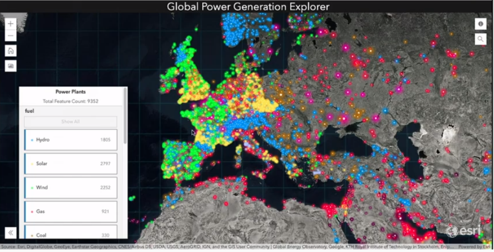
Jeremy Bartley transitions into a focus on mapping and styling to enhance data analysis, powered by the power of JavaScript. JavaScript for ArcGIS supports speed, mobile responsiveness, and dynamic styling.
Jennifer Bell demonstrates these capabilities in Map Viewer Beta. She briefly showed the variations of color ramps available, with options for colorblindness and dark-theme backgrounds. She also demonstrates the dot density feature and the capability to see overlapping data segments with a color-blending feature.
 Configurable App Capabilities (4 min)
Kelly Hutchins introduced how JavaScript is working in configurable apps available in ArcGIS Online and ArcGIS Enterprise. An interactive legend allows end users to filter feature layer data to see categories of their choosing and create a printout with a screenshot tool. Using open feature layers from OpenStreetMap Amenities for North America, see how Kelly configured an app to show restaurants filtered by distance and categories.
All apps are open source and available in GitHub for source code on the latest configurable apps including the one in her demo: http://esriurl.com/cats
Related Session: Esri Location Services for Developers 55 min
Dashboard and Arcade (6 min)
David Nyenhuis highlighted a few dashboards and their capabilities and announced the new beta with JavaScript capabilities would be released soon. With Arcade, scripts can now be authored within dashboards with a live preview of the code. Using a Fire Incidents Dashboard, he demonstrated how to use Arcade to create an expression for important data and formatted specific details to indicate where attention was needed the most.
Related Session: ArcGIS API for JavaScript: Using Arcade with your Apps 49 min - added 4/21/2020
Custom Web Applications (6 min)
Kristian Ekens demonstrated how JavaScript capabilities and the new Spilhaus projections could enhance oceanic data rendering. Data fields amounting to more than 200 megabytes in size could be explored with speed as a result of JavaScript API’s client-side query engine. He went on to show how dynamic color and icon visualization worked with the code and Arcade expressions and more.
 3D Mapping (9 min)
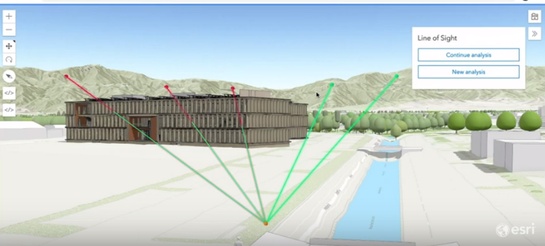
Arno Fiva demonstrated how to interact with details of buildings under construction, including floors, doors, and stairs with the Building Explorer feature. In December, two new tools were released for interactive visualization, including the daylight tool and the line of sight tool, which provide perspective on the visual impact of a construction project within its environment. Layered 3D Imagery collected by drones can also interact with other 3D layer types with Building Explorer. In the next JavaScript release, interactive 2D features will be available.
Other capabilities demoed include quick styling of 3D skylines, a 3D rendering of earthquakes around the world, and a model of a ski resort’s slopes and features, all powered by JavaScript API.
Related Session: ArcGIS Indoors: Developing Indoor Mapping Apps 30 min
Mapping Technology (7 min)
How is map rendering achieved so quickly? Jeremy Bartley takes us “behind the scenes” to understand how fast rendering works. After Jeremy reviewed the process behind feature tile queries, he pointed out key improvements in the load time, accuracy and memory profile, triangulation processing, and line rendering. Speed improvements made behind the technology are also applicable to data styling and updates.
 Spatial Analysis and Data Science (9 min)
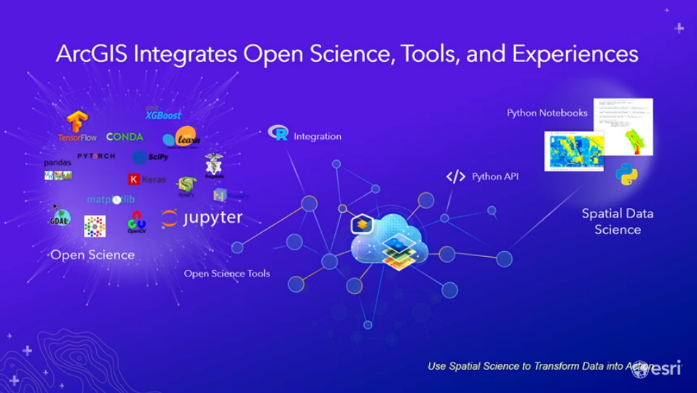
Jay Theodore, Chief Technology Officer of ArcGIS Enterprise, shared an overview of how ArcGIS works as a comprehensive spatial analysis and data science platform. Learn about three new features that were introduced and see a demonstration from Ankita Bakshi on out of the box capabilities with ArcGIS Pro and Jupyter Notebooks.
Data Science Sessions:
- ArcGIS API for Python: Analysts and Data Science 1 hr
- Spatial Data Science – A Tour 1 hr 30 min
- ArcGIS Insights: Python/R Scripting and Advanced Analytics 50 min
- Best Practices for Building Web Apps that Visualize Large Datasets 1 hr 11 min
- Unpacking the Black Box: Spatial Data Science Methods Explained 1 hr 4 min
- See more Data Science Sessions in the https://community.esri.com/community/events/devsummit/blog/2020/04/08/2020-devsummit-session-videos-...
Distributed GeoAnalytics (4 min)
Sarah Ambrose demonstrated how the ArcGIS GeoAnalytics server works with Apache Spark. To analyze a large dataset of Uber rides, Sarah applied a spatiotemporal clustering algorithm that used Apache Spark to determine unique activity of rideshare demands in a city. With an even larger data set and a custom analysis criteria, she streamlined an analysis workflow with PySpark code.
See the demo.
Related Sessions:
- Geospatial Analytics and AI at Scale with Big Data Toolkit 57 min - added 4/15/2020
- Big Data and ArcGIS: An Introduction to ArcGIS GeoAnalytics Server 58 min - added 4/17/2020
- GeoAnalytics in ArcGIS Pro: Geoprocessing in Parallel Using Apache Spark 48 min - added 4/17/2020
Multidimensional Analysis Using Raster Analytics (4 min)
With the Python API, you can access multidimensional analysis tools. Vinay Viswambharan used an example of predicting the risk of coral reef bleaching using sea surface data from ArcGIS Living Atlas of the World. After condensing the data from 4,00 slices of daily data imagery into weekly imagery, he applied a trend raster function as an input to a prediction function in ArcGIS Notebook. See how he furthered his analysis with calls for temperature anomalies and created maps and dashboards.
Related Sessions:
- Advanced Analysis of Satellite Imagery Using Python 47 min - added 4/21/2020
- Advanced Custom Raster Processing Using Python 58 min - added 4/21/2020
- Managing and Sharing Raster Data for Analysis 1 hr 24 min - added 4/21/2020
 Deep Learning: arcgis.learn
Jay Theodore returned to the stage to review the process of how the model for deep learning works and to introduce how ArcGIS simplified the workflow with arcgis.learn. Lidar, video, unstructured text, and multispectral imagery are all new ways to enrich deep learning with arcgis.learn.
Related Session: Object Detection from Lidar using Deep Learning with ArcGIS 1 hr
Full Motion Video (6 min)
Shannon Kalinsky showed how drone video footage could help a university analyze the population of catfish in a river. By applying a training model with Python API, the software helped identify catfish in each frame of the video and provide insights on helpful descriptive details.
Related Session: Driving Intelligence from Video and Oriented Imagery at Scale Using AI in ArcGIS 30 min
Deep Learning and 3D Mapping (4 min)
Dmitry Kudinov showed how significant man-hours could be reduced by using deep learning to analyze point clouds for labeling power lines. He showed the code to train PointCNN to detect wires and utility poles and determined a learning rate. Within ArcGIS Pro, he can preview the learning results and compare ground truth data.
Related Sessions:
- From Experimentation to Production: Building Enterprise Scalable GeoAI Systems 30 min
- Geospatial Deep Learning with ArcGIS 58 min - added 4/21/2020
 Natural Language Processing: Unstructured Data (4 min)
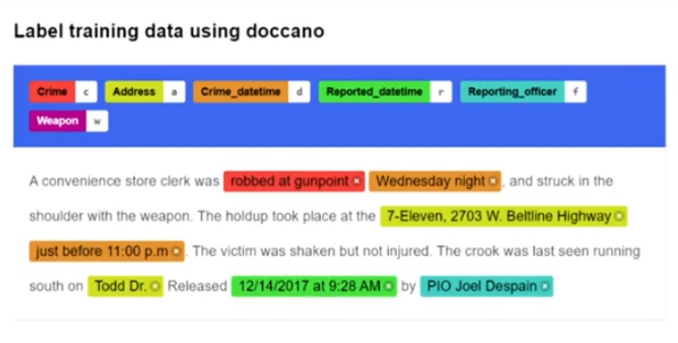
Lauren Bennett showed how unstructured spatial data could be organized for analysis. With arcgis.learn, she demonstrated how to train and deploy an entity recognizer model. The model analyzed relevant data points and attributes for a police agency’s extensive data set and quickly displayed results on a map.
See the demo.
SDKs for ArcGIS Pro & ArcGIS Enterprise
SDKs for ArcGIS Pro & ArcGIS Enterprise (10 min)
Jim McKinney returned to the stage to review how products are expanded with ArcObjects, ArcGIS Pro, and ArcGIS Enterprise solutions. ArcObjects is used for customizing and extending ArcMap, ArcGIS Desktop, and ArcGIS Server. Although it will continue to be supported, Jim encourages new development work to start utilizing the technology for ArcGIS Enterprise, ArcGIS Pro, and standalone apps in ArcGIS Runtime.
- Find ArcObject resources and support in GitHub.
For customizing ArcGIS Pro, ArcGIS Pro SDK for Microsoft .NET has new extensibility pattern supports for add-ins, solution configurations, and plug-in data sources for high customization capabilities.
- ArcGIS Pro SDK for .NET: Beginning Pro Customization Showing Pro Extensibility 1 hr
- ArcGIS Pro SDK for .NET: An Overview of the Geodatabase API 59 min - added 4/17/2020
- ArcGIS Pro SDK for .NET: An Overview of the Utility Network Management API 1 hr 10 min - added 4/17/2020
ArcGIS Pro SDK for .NET: Understanding Feature Services, a Guide for Developers 52 min - added 4/21/2020
ArcGIS Pro SDK for .NET: Real-time Analysis Visualization using ArcGIS Pro Real-time API 47 min - added 4/21/2020
- ArcGIS Pro SDK for .NET: Demonstrating Extensibility with Partner Add-Ins 40 min - added 4/21/2020
- ArcGIS Pro SDK for .NET: Introduction to the Parcel Fabric API 1 hr 3 min - added 4/22/2020
- ArcGIS Pro SDK for .NET: Enhancing the Managed API using the Cartographic Information Model (CIM) 1 hr - added 4/23/2020
- ArcGIS Pro SDK for .NET: Advanced Editing with Focus on UI Customization 44 min - added 4/23/2020
- ArcGIS Pro SDK for .NET: Beginning Editing with Focus on EditOperation 47 min - added 4/23/2020
Add-Ins
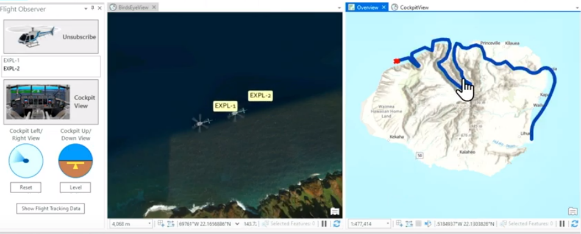 Wolfgang Kaiser demonstrated how an add-in performs for tracking helicopter flights in ArcGIS Pro The add-in is using stream data to update the helicopter location and auto-pans the map to keep up with the location of the helicopters within the screen view, along with a cockpit view, elevation data, and more.
ArcPy
What’s New in ArcPy (5 min)
Rachel Applebaum used ArcPy to find out how to visit the most available open houses. By applying an ArcGIS API for Python tool, she was able to hide the open houses she wouldn’t be able to make it to and label a pathway of houses in a navigation order that fits within the timeframe of the various open house schedules. This capability was enabled by the new Network Analyst arcpy module.
Related Session:
- ArcPy: Beyond the Basics of arcpy.mp 53 min
- ArcPy: Working with Feature Data 25 min - added 4/23/2020
Automation
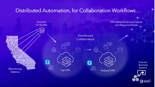 Monitoring & Reporting Air Quality and Scheduling Notebooks with ArcGIS Enterprise (15 min)
Before exploring monitoring and reporting air quality, Jay Theodore explained what drives the need for automation and how it works for different professional roles. He shows models for how it scales for enterprises and minimizes routine tasks.
Indhu Kamala Kumar and Bill Major demonstrated some of the automation possibilities with an air quality agency that needed to share data on a routine basis through ArcGIS Notebooks Learn more about the range of automation tools that are at your fingertips in ArcGIS.
See the demo: Monitoring & Reporting Data | Scheduling Notebooks for Reporting
Related Session: Distributed Collaboration: Sharing Data Across Systems 1 hr - added 4/17/2020
Mapping & Analyzing Bike and Scooter Shares in Washington, D.C. (4 min)
Shannon Kalinsky returned with Shreyas Shinde to explore other automation scenarios with the use of ArcGIS Notebooks and ArcGIS Dashboards. See how they used automation to build their data on the location of ridesharing bikes and scooters to develop insights.
App Builders: Web AppBuilder for ArcGIS, ArcGIS Experience Builder, and AppStudio for ArcGIS
Building Web Apps & Experiences (7 min)
Jianxia Song demonstrates the convenience of Experience Builder by showing how to build an immersive web experience with templates. Within moments, Jianxia assembled a website with an informative map and an embedded Survey123 for ArcGIS feature to prompt readers to report about feeling an earthquake.
Building for Native Applications with AppStudio (7 min)
Chris LeSueur showed simple steps to build an app for an organization that works online and offline. See how you can quickly launch a branded application for your organization and how to can scale up your apps with machine learning tools using arcgis.learn.
Related Sessions:
- ArcGIS Experience Builder: Getting Started with Creating Web Solutions 55 min
- ArcGIS Experience Builder: Building Web Solutions, Advanced Topics 1 hr 8 min
- Web AppBuilder for ArcGIS: A Deep Dive in Enterprise Deployments 46 min - added 4/21/2020
Field Apps
Esri Leaflet
- Building Apps with Esri Leaflet 30 min - added 4/15/2020
Survey123 for ArcGIS and ArcGIS QuickCapture
- What's New in Survey123 53 min - added 4/22/2020
- Extending the Survey123 Field App 41 min - added 4/22/2020
- What's New in ArcGIS Quick Capture 54 min - added 4/22/2020
JavaScript
Web Development with Modern JavaScript (5 min)
There are a few ways to stay ahead of what’s coming, increase your knowledge, and stay connected with current developments for enhancing your work with JavaScript. A variety of content is available on GitHub, Esri Developer pages, and GeoNet posts to help you learn and see what’s new. For what’s coming, check out the video to learn about how Esri is modernizing the API and how we’re working with new integration capabilities.
Using & Customizing JavaScript Widgets (4 min)
Matt Driscoll showed how to use ArcGIS API for JavaScript to enhance map features and map exploration with custom pop-ups, interactive feature tables, and more.
Web Development on the Command Line (3 min)
Rene Rubalcava showed new capabilities with ArcGIS CLI arcgis-cli, including the option to choose your framework and UI tools to build new applications. You can now also save your web maps to pull open in other ArcGIS software.
Related Sessions:
- ArcGIS API for JavaScript: What's New 50 min - added 4/21/2020
- See more ArcGIS API for JavaScript Sessions in the https://community.esri.com/community/events/devsummit/blog/2020/04/08/2020-devsummit-session-videos-...
ArcGIS Runtimes
Developing Apps for Offline Use (6 min)
If your primary need is to create apps that work offline, the ArcGIS Runtimes have a few new enhancements. See solutions working with for polygon areas, scheduled map updates, and for using existing offline basemaps with features demonstrated by Michael Branscomb.
Related Sessions:
Map Layers & Data: 2D & 3D Visualization (5 min)
After Euan Cameron reviewed a range of data that could be loaded in Runtime, David Cardella, demonstrated six new 2D and 3D visualization packages available in ArcGIS Runtime. The packages include mobile scene packages, point cloud layers, point scene layers, and more.
App Development Utilities (5 min)
Augmented Reality features for mobile devices and Runtime SDKs have fly over, tabletop, and world scale modes that were released into production and a new navigation support feature with voice guidance that works online and offline.
See the demo.
With ArcGIS Runtime and Utility Network’s new trace type, Michael Branscomb shows how utility companies can analyze outages and coordinate a response.
See the demo.
Related Sessions:
- ArcGIS Runtime SDK for .NET: Building Windows Apps 1 hr 12 min
- ArcGIS Runtime: An Introduction to the API and Architecture 1 hr
- ArcGIS Runtime: Authenticating Your Apps with the ArcGIS Platform 57 min
- ArcGIS Runtime: Utilities 37 min
- ArcGIS Runtime SDKs: Optimizing Your Data Workflows for Working Offline 50 min
Network Management with ArcGIS Advanced Capabilities of the Utility Network 1 hr 6 min - added 4/17/2020
Network Management with ArcGIS - Introduction to the Utility Network 54 min - added 4/17/2020
Map Symbology
Map Symbology Across the ArcGIS Platform (9 min)
Cartographic Information Model (CIM) is now supported in the JavaScript API along with a dictionary style. See how this works in a demonstration from Kerry Robinson. If you create a dictionary that you’re proud of, share your example and remember to use this “catchy” hashtag: #ArcGISArcadeDictionaryWebStylin
ArcGIS and Game Engines
ArcGIS and Game Engines (10 min)
Get an understanding of the advantages of utilizing game engines with ArcGIS, what to expect with the integrations and a demo of the exciting new capability from Adrien Meriaux and Ferran Prat.
Related Sessions:
Follow Esri Events on YouTube for more videos from the 2020 DevSummit Virtual Sessions or follow our ongoing list here.
- 2d map
- 3d analysis
- 3d map
- 3d visualization
- ai
- ai and machine learning
- appbuilders
- arc gis pro sdk
- arcgis indoors
- arcgis notebooks
- arcgis-cli
- arcgis.learn
- arcgisarcadedictionarywebstylin
- arcobjects
- arcpy
- artificial intelligence
- basemap imagery
- copying symbology
- covid-19
- deep learning
- developers
- devsummit 2020
- download offline map
- drone imagery
- field operations
- full motion video
- game design
- geoenabled systems
- location analytics
- location services
- machine deep learning
- multidimensional analysis
- natural language processing
- offline basemap
- offline editting
- raster analytics
- real time data
- real-time analytics
- real-time gis
- saved symbology
- spatial analysis
- spatial data science
- symbol dictionary
- technical sessions
- utility-network
- vr
- web-appbuilder
Dear all
i would like to send me link to be able to gain DEM of Yemen and shipfiles
Please make sure that the Developer Summit overview page gets updated to show all the video links. It only contains a link to the plenary video.
Thanks Ken for your feedback, We will pass it along to the web team and Developer team, as that page is not within GeoNet.
Hiya Ken Buja! I hope you are doing well! It was so nice to see you at Fed!
Our team is currently working to update the page, and it should have the link to the rest of the DevSummit tech session videos soon! Here is the link to the YouTube playlist where they are currently being uploaded daily over the next two weeks. If you should have any questions, please do not hesitate to contact me.
Thanks again for being so helpful, and I look forward to seeing you again soon!
Thank you for the list.
By the way, is it possible to get some of the DevSummit presentation files(.pptx)?
It will be helpful for me to strengthen my resources to guide customers.
Thank you.
Best,
Joora
-
 Anonymous User