- Home
- :
- All Communities
- :
- Developers
- :
- Developers - General
- :
- Developers Questions
- :
- Re: working with IWorkspaceFactory in ArcGIS Runti...
- Subscribe to RSS Feed
- Mark Topic as New
- Mark Topic as Read
- Float this Topic for Current User
- Bookmark
- Subscribe
- Mute
- Printer Friendly Page
working with IWorkspaceFactory in ArcGIS Runtime SDK
- Mark as New
- Bookmark
- Subscribe
- Mute
- Subscribe to RSS Feed
- Permalink
What is the "ArcGIS Runtime SDK" name space to use in C# to access IWorkspaceFactory object model?
(Please note that I need the name space in "Esir.ArcGISRuntime" ant NOT "Esri.ArcGIS")
Message was edited by: Behzad Rouhieh
- Mark as New
- Bookmark
- Subscribe
- Mute
- Subscribe to RSS Feed
- Permalink
IWorkspaceFactory belongs to the ArcObjects SDK (i.e. Esri.ArcGIS.Geodatabase.IWorkspaceFactory).
IWorkspaceFactory
http://resources.arcgis.com/en/help/arcobjects-net/componenthelp/index.html#//002500000m9w000000
Are you wanting to use ArcObjects or the ArcGIS for Runtime SDK. The runtime SDK would not utilize this interface. What type of workspace are you needing to open? If you're using the Runtime SDK I'd assume you're referring to Esri.ArcGISRuntime.LocalServices.WorkspaceFactoryType enumeration.
WorkspaceFactoryType Enumeration
The above interface is what you'd use in runtime to specify the workspace type when creating a dynamic workspace.
- Mark as New
- Bookmark
- Subscribe
- Mute
- Subscribe to RSS Feed
- Permalink
Thank you for the reply. I want to use "WorkspaceFactoryType" to connect to a personal geodatabase in .NET environment. I have "Esri.RcGISRuntime" SDK package installed. I could not find the namespace for WorkspaceFactoryType. I will try the one you suggested.
- Mark as New
- Bookmark
- Subscribe
- Mute
- Subscribe to RSS Feed
- Permalink
WorkspaceFactoryType would not contain an enum for Personal Geodatabases. You'd need to convert your data to either a shapefile or a file/enterprise geodatabase.
- Mark as New
- Bookmark
- Subscribe
- Mute
- Subscribe to RSS Feed
- Permalink
Thanks Freddie. Will I be able to read/edit features of an ".mdb" file created from the desktop Application using WorkspaceFactory?
- Mark as New
- Bookmark
- Subscribe
- Mute
- Subscribe to RSS Feed
- Permalink
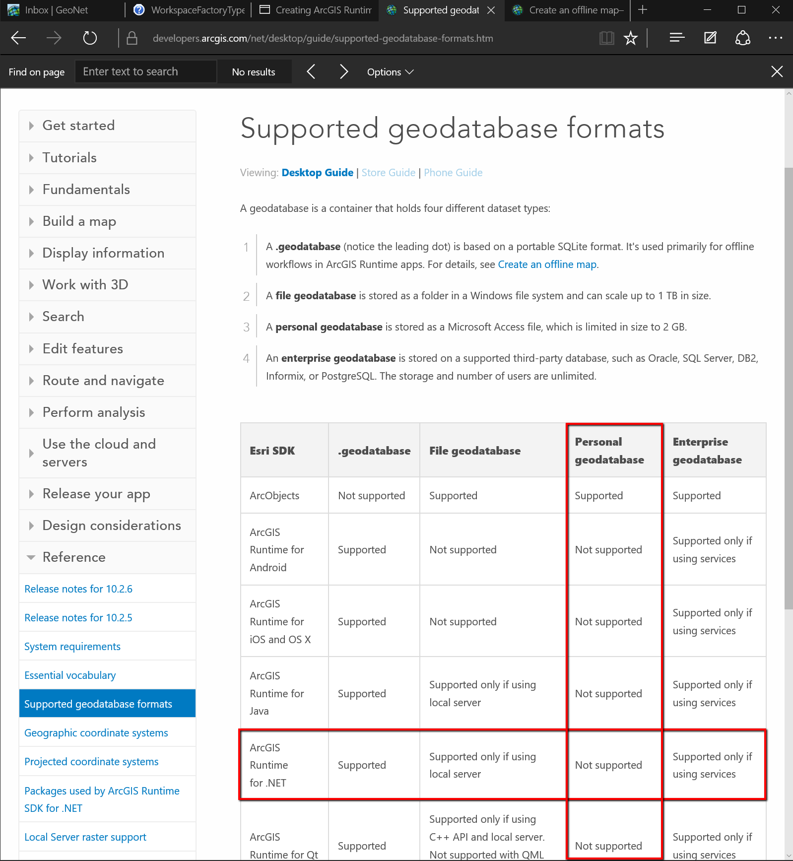
For personal geodatabases the answer would be no because the Runtime APIs do not support personal geodatabases. I've pointed to the documentation that states this below.
Although runtime won't allow you to edit personal geodatabases directly, I may be able to point you to another workflow that would allow you to adopt this API. Could you provide more information on the workflow you're needing to accomplish with the runtime sdk? Also, do you have access to ArcGIS Server?
Supported Geodatabase Formats
https://developers.arcgis.com/net/desktop/guide/supported-geodatabase-formats.htm

- Mark as New
- Bookmark
- Subscribe
- Mute
- Subscribe to RSS Feed
- Permalink
Oh I did not know that. I do NOT have access to ArcGIS Server. I have a shape file (with data table attached) and I want to be able to open that in .NET, change the table fields, featuretable (Polyline color, width,etc.) ad display it in .NET as a layer on the map. Do you have any other suggestion that might work?
- Mark as New
- Bookmark
- Subscribe
- Mute
- Subscribe to RSS Feed
- Permalink
Are you only needing to modify the data and display the data in runtime? If yes you could leverage a runtime geodatabase (i.e. the file that ends with the .geodatabase extension). If you wanted to use a shapefile you could load the data into runtime and manipulate it, but you would not be able to persist the data changes back to the source shapefile.
Creating ArcGIS Runtime Content
- Mark as New
- Bookmark
- Subscribe
- Mute
- Subscribe to RSS Feed
- Permalink
I tried creating runtime content as .geodatabase extensdion. However, in .NET, with basic license, I can only read the data, not edit them. In order to edit the file, Standard license is required!