Turn on suggestions
Auto-suggest helps you quickly narrow down your search results by suggesting possible matches as you type.
Cancel
- Home
- :
- All Communities
- :
- Products
- :
- Data Management
- :
- Data Management Questions
- :
- Split / Divide large polygon with point shapefile
Options
- Subscribe to RSS Feed
- Mark Topic as New
- Mark Topic as Read
- Float this Topic for Current User
- Bookmark
- Subscribe
- Mute
- Printer Friendly Page
Split / Divide large polygon with point shapefile
Subscribe
12-02-2013
07:58 AM
- Mark as New
- Bookmark
- Subscribe
- Mute
- Subscribe to RSS Feed
- Permalink
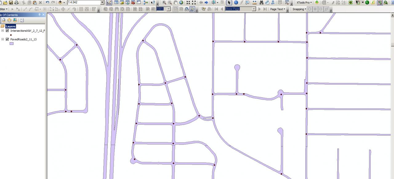
I have a large polygon shapefile that represents streets and a large point shapefile that represents intersections.
Is there a way to split the polygon shapefile at each intersection point?
[ATTACH=CONFIG]29493[/ATTACH]
Is there a way to split the polygon shapefile at each intersection point?
[ATTACH=CONFIG]29493[/ATTACH]
Solved! Go to Solution.
1 Solution
Accepted Solutions
12-05-2013
06:17 AM
- Mark as New
- Bookmark
- Subscribe
- Mute
- Subscribe to RSS Feed
- Permalink
You need to use the voids between the roads as your polygons. If you don't have that, create it using the "erase" tool under "overlay".
Create a polygon surrounding your roads, erase the road spaces, then explode the resultant polygon to create the voids.
Create a polygon surrounding your roads, erase the road spaces, then explode the resultant polygon to create the voids.
24 Replies
12-02-2013
08:07 AM
- Mark as New
- Bookmark
- Subscribe
- Mute
- Subscribe to RSS Feed
- Permalink
What's your end goal here?
12-02-2013
08:18 AM
- Mark as New
- Bookmark
- Subscribe
- Mute
- Subscribe to RSS Feed
- Permalink
Basically I would like to have individual polygons intersection to intersection.
12-02-2013
08:24 AM
- Mark as New
- Bookmark
- Subscribe
- Mute
- Subscribe to RSS Feed
- Permalink
Do you then need to name the polygons etc? What do you fully need as a final product?
12-02-2013
08:26 AM
- Mark as New
- Bookmark
- Subscribe
- Mute
- Subscribe to RSS Feed
- Permalink
The only way I see is, creating a buffer around your points and using that polygon file to cut your street file.
12-02-2013
08:30 AM
- Mark as New
- Bookmark
- Subscribe
- Mute
- Subscribe to RSS Feed
- Permalink
Need a "new" polygon shapefile that has intersection to intersection polygons.
No need to name the polygons, though would be nice..
I will be using these individual polygons to calculate square feet and items contained within
each polygon for assest management.
No need to name the polygons, though would be nice..
I will be using these individual polygons to calculate square feet and items contained within
each polygon for assest management.
12-02-2013
08:33 AM
- Mark as New
- Bookmark
- Subscribe
- Mute
- Subscribe to RSS Feed
- Permalink
I agree with Tim, but it could get messy.
12-02-2013
08:34 AM
- Mark as New
- Bookmark
- Subscribe
- Mute
- Subscribe to RSS Feed
- Permalink
I have tried the buffer option by doesn't seem to work because of the intersections are not consistant in size or configuration, some our 2 leg, 3 leg, 4 leg, and 5 leg intersections.
12-02-2013
08:39 AM
- Mark as New
- Bookmark
- Subscribe
- Mute
- Subscribe to RSS Feed
- Permalink
That's the messy part. I think you're in for a lot of manual work here either way, unless you have a convenient road segment polyline file with width data included.
12-02-2013
08:40 AM
- Mark as New
- Bookmark
- Subscribe
- Mute
- Subscribe to RSS Feed
- Permalink
Someone in our organization has done this before but now I am tasked with reproducing an update and unable contact the person who originally completed the task. See the attached. somehow it looks as if lines where placed at the points on intersections and then processed.[ATTACH=CONFIG]29499[/ATTACH]