Turn on suggestions
Auto-suggest helps you quickly narrow down your search results by suggesting possible matches as you type.
Cancel
- Home
- :
- All Communities
- :
- Products
- :
- Data Management
- :
- Data Management Questions
- :
- Split / Divide large polygon with point shapefile
Options
- Subscribe to RSS Feed
- Mark Topic as New
- Mark Topic as Read
- Float this Topic for Current User
- Bookmark
- Subscribe
- Mute
- Printer Friendly Page
Split / Divide large polygon with point shapefile
Subscribe
12-02-2013
07:58 AM
- Mark as New
- Bookmark
- Subscribe
- Mute
- Subscribe to RSS Feed
- Permalink
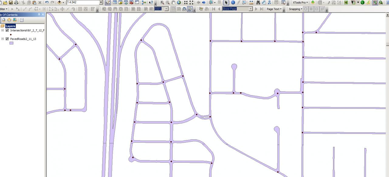
I have a large polygon shapefile that represents streets and a large point shapefile that represents intersections.
Is there a way to split the polygon shapefile at each intersection point?
[ATTACH=CONFIG]29493[/ATTACH]
Is there a way to split the polygon shapefile at each intersection point?
[ATTACH=CONFIG]29493[/ATTACH]
Solved! Go to Solution.
24 Replies
12-02-2013
08:41 AM
- Mark as New
- Bookmark
- Subscribe
- Mute
- Subscribe to RSS Feed
- Permalink
I do have a road segment polyline file but no width data included.
12-02-2013
08:47 AM
- Mark as New
- Bookmark
- Subscribe
- Mute
- Subscribe to RSS Feed
- Permalink
looks like they might have used a distance to polygon type of thing using the polygons between the roads, then used the resultant lines to cut the roads
12-03-2013
06:32 AM
- Mark as New
- Bookmark
- Subscribe
- Mute
- Subscribe to RSS Feed
- Permalink
Could you use the streets as lines in the Create Polygons tool? This might result in some extra polygons, but less manual work than other approaches. This seems too easy though, I must be missing something.
12-03-2013
11:33 AM
- Mark as New
- Bookmark
- Subscribe
- Mute
- Subscribe to RSS Feed
- Permalink
I recall using a tool a couple of years ago (it escapes me now) that took a point file, and created a shape file layer of polylines that gave minimum distances from each point to each polygon in the other layer (in this case the polygons between the road polygons).
This looks like what was done here, but delete any polylines with length greater than the road width, and use that polyline shape file to cut the road polygons.
This looks like what was done here, but delete any polylines with length greater than the road width, and use that polyline shape file to cut the road polygons.
12-04-2013
08:06 AM
- Mark as New
- Bookmark
- Subscribe
- Mute
- Subscribe to RSS Feed
- Permalink
I would have thought there would be a tool out there somewhere, I have seen other files from other agencies that where done this same way while searching for a solution but no one will let me in on the "secert".:)
12-04-2013
08:08 AM
- Mark as New
- Bookmark
- Subscribe
- Mute
- Subscribe to RSS Feed
- Permalink
"secret".:)
12-04-2013
08:22 AM
- Mark as New
- Bookmark
- Subscribe
- Mute
- Subscribe to RSS Feed
- Permalink
pssst...hey bud...
I think is was one of the spider diagram tools in ET Geowizards
I recall using a tool a couple of years ago (it escapes me now) that took a point file, and created a shape file layer of polylines that gave minimum distances from each point to each polygon in the other layer (in this case the polygons between the road polygons).
This looks like what was done here, but delete any polylines with length greater than the road width, and use that polyline shape file to cut the road polygons.
I think is was one of the spider diagram tools in ET Geowizards
12-04-2013
09:11 AM
- Mark as New
- Bookmark
- Subscribe
- Mute
- Subscribe to RSS Feed
- Permalink
Found it, but it's point to point, not point to feature unfortunately.
http://arcscripts.esri.com/details.asp?dbid=14908
You need to find a script or tool that will draw a polyline from each intersection point to each "void" polygon to get started.
http://arcscripts.esri.com/details.asp?dbid=14908
You need to find a script or tool that will draw a polyline from each intersection point to each "void" polygon to get started.
12-04-2013
09:22 AM
- Mark as New
- Bookmark
- Subscribe
- Mute
- Subscribe to RSS Feed
- Permalink
Do you think this will work in ArcGIS 10.0?
I am thinking you're on the right track with the spider diagram looking at the examples I have, THANKS!
I'll let you know.
I am thinking you're on the right track with the spider diagram looking at the examples I have, THANKS!
I'll let you know.
12-04-2013
10:57 AM
- Mark as New
- Bookmark
- Subscribe
- Mute
- Subscribe to RSS Feed
- Permalink
spend a couple of hundred dollars on ET Geowizards, well worth the money for us poor ArcGIS Basic users.
http://www.ian-ko.com/
You can download it for free and use the "non-free" tools for a while.
Use Spatial Relations and Allocations\Spider Diagram - Attribute Link
Ensure that there is a field in each of the intersection and void polygon layers that have identical values (I created a field in each called NewID and populated all with zeros. If the are unique it will only do matching polygons)
Eliminate all of the unwanted polylines in the resultant shape file (i.e. lines > 5 m etc.)
Use resultant polyline shape file with the Polygon\Split Polygons with Polylines tool to split your road polygons.