- Home
- :
- All Communities
- :
- Products
- :
- Data Management
- :
- Data Management Questions
- :
- project to UTM 16n deletes records from point shap...
- Subscribe to RSS Feed
- Mark Topic as New
- Mark Topic as Read
- Float this Topic for Current User
- Bookmark
- Subscribe
- Mute
- Printer Friendly Page
project to UTM 16n deletes records from point shapefile
- Mark as New
- Bookmark
- Subscribe
- Mute
- Subscribe to RSS Feed
- Permalink
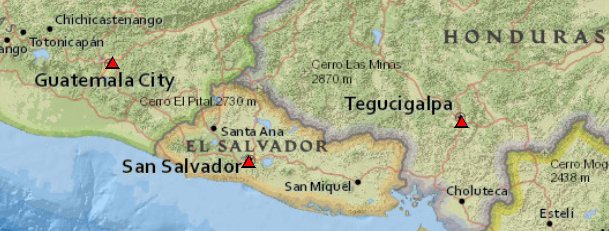
I have a simple 3 record file of country capitals that I created with Notepad++ text editor. I imported it into ArcMap 10.3.1 on Win 10 Pro (fully updated), using File, AddXY.
-90.5069,14.6349,1
-87.1921,14.0723,2
-89.2182,13.6929,3
I did File, Data, Export to create a shapefile. I set a projection of GCS_WGS_1984. The imported file table has the following fields (see attached PNG file): FID, Shape, Field1, Field2, Field3
However, now when I try to project the file from Geographic to UTM16n the resulting projected file is missing the first two records. No records are selected in the original file before the reprojection. I have tried this multiple times, restarted ArcMap, rebooted the computer, and now I am crying for help. A PNG of my tables is attached for proof of this annoyance. Why is this happening and how can I make my ArcGIS return to "normal"?
Solved! Go to Solution.
Accepted Solutions
- Mark as New
- Bookmark
- Subscribe
- Mute
- Subscribe to RSS Feed
- Permalink
If at first you don't succeed, try try again... I tried and tried. I created the file in TerrSet and it worked fine there, but even the shapefile ported from TerrSet in ArcMap would fail on projection. So I started looking at other responses to other questions. And I came upon one where someone had a failed mxd file. And for a lark, I threw away my long in use current mxd file and tried a new one. It worked just fine. So something in the mxd file must have been causing those records to be selected when I was projecting. All is well now. I will reopen the files from the other mxd carefully and start again. Thanks for your assistance.
- Mark as New
- Bookmark
- Subscribe
- Mute
- Subscribe to RSS Feed
- Permalink
the coordinates look right, the only thing I can think of is that you may have had a record selected when you did the reprojection and not noticed it. Try it again, but make sure there are no selected records when doing so... many have claimed that they didnt have a selection only to find out that they did.
PS, you did make X the longitude and Y the latitude and not go by the default? just checking
- Mark as New
- Bookmark
- Subscribe
- Mute
- Subscribe to RSS Feed
- Permalink
I appreciate your effort to help me. I redid all, carefully, I made sure that X was Field1, Y was Field2, and Z was Field3, and was very careful not to select any records of the table other than to open it to see it. And I did every step carefully, and yet, it happened once again. My result only has one record with Field3 of 3.
- Mark as New
- Bookmark
- Subscribe
- Mute
- Subscribe to RSS Feed
- Permalink
so to summarize.
Your shapefile in GCS WGS84 shows up fine.
But when you project it, using the Project tool, only 1 record is created in the projected file... correct?
Did you try another projection other than UTM 16N like some regional projection used in that area? If not try it. because -90is is on the edge of UTM 16 and 15 N but it seems indescriminant in which point it picks. Don't they have an albers or similar for that area?
- Mark as New
- Bookmark
- Subscribe
- Mute
- Subscribe to RSS Feed
- Permalink
UTM 16N works fine (for me).
- Mark as New
- Bookmark
- Subscribe
- Mute
- Subscribe to RSS Feed
- Permalink
Well good, that just leaves the selection of a record prior to projection issue, which apparently has also been ruled out... leaving a well-defined workflow producing an unexpected result for one individual
- Mark as New
- Bookmark
- Subscribe
- Mute
- Subscribe to RSS Feed
- Permalink
I've got good news and bad news.
The good news is that your coordinates are perfectly fine.
The bad news is that I followed your instructions exactly and all 3 points showed up, so I can't tell you why you only see one point.
- Mark as New
- Bookmark
- Subscribe
- Mute
- Subscribe to RSS Feed
- Permalink
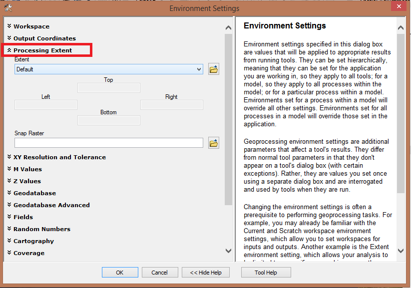
Check Tool Environment before ,specially Processing Extent
- Mark as New
- Bookmark
- Subscribe
- Mute
- Subscribe to RSS Feed
- Permalink
The would have been a big omission in the workflow since the default extent is maximum of inputs except for some tools
Output Extent (Environment setting)—Help | ArcGIS for Desktop
and in the case of a projection, the Project tool Project—Help | ArcGIS for Desktop
The extent isn't even one of the parameters that it honors and since it was a shapefile, 2 don't even apply, see the project ool environments options below
Environments
- Mark as New
- Bookmark
- Subscribe
- Mute
- Subscribe to RSS Feed
- Permalink
If at first you don't succeed, try try again... I tried and tried. I created the file in TerrSet and it worked fine there, but even the shapefile ported from TerrSet in ArcMap would fail on projection. So I started looking at other responses to other questions. And I came upon one where someone had a failed mxd file. And for a lark, I threw away my long in use current mxd file and tried a new one. It worked just fine. So something in the mxd file must have been causing those records to be selected when I was projecting. All is well now. I will reopen the files from the other mxd carefully and start again. Thanks for your assistance.