- Home
- :
- All Communities
- :
- Products
- :
- Data Management
- :
- Data Management Questions
- :
- Georeferencing Google Earth Screenshots
- Subscribe to RSS Feed
- Mark Topic as New
- Mark Topic as Read
- Float this Topic for Current User
- Bookmark
- Subscribe
- Mute
- Printer Friendly Page
Georeferencing Google Earth Screenshots
- Mark as New
- Bookmark
- Subscribe
- Mute
- Subscribe to RSS Feed
- Permalink
Hi all, I have recently georeferenced some screenshots from google earth by using Inputs X and Y and keyed in the lat long. However, I realised that the values I have keyed in have units as meters and not degrees. As such, I am having trouble now while trying to digitise some parcels because the combined raster image is too small for digitisation to be done.
How can I convert the units for the X and Y that I have keyed in from meters into degrees? Sadly, I accidentally deleted the individual georeferenced images after I have merged them into one using mosaic.
- Mark as New
- Bookmark
- Subscribe
- Mute
- Subscribe to RSS Feed
- Permalink
If you know the UTM Zone you are working in, here is a UTM to Decimal Degrees Converter.
Geographic/UTM Coordinate Converter
Steven
- Mark as New
- Bookmark
- Subscribe
- Mute
- Subscribe to RSS Feed
- Permalink
Hi Hazel,
From ArcCatalog, right-click the image that you had georeferenced > Properties. Scroll down to spatial reference > Click Edit.
In Spatial Reference properties dialog box, go to Geographic Coordinate System > World > WGS 1984. Select it. Click OK > Click OK.
Open the image in a new ArcMap session. Hope it resolves the issue.
Thanks,
Jay
Think Location
- Mark as New
- Bookmark
- Subscribe
- Mute
- Subscribe to RSS Feed
- Permalink
Hi Jay
I have just tried your method but my raster layer has already been set at PCS WGS1984. Hence the issue is still persisting.
- Mark as New
- Bookmark
- Subscribe
- Mute
- Subscribe to RSS Feed
- Permalink
It should be GCS WGS 1984, not PCS. And you don't have to georeference it again
Think Location
- Mark as New
- Bookmark
- Subscribe
- Mute
- Subscribe to RSS Feed
- Permalink
Here is the snapshot for you
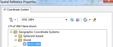
Think Location
- Mark as New
- Bookmark
- Subscribe
- Mute
- Subscribe to RSS Feed
- Permalink
Hi Jay, thanks a lot for your advice. I will try it again tomorrow. Hopefully it will work.
- Mark as New
- Bookmark
- Subscribe
- Mute
- Subscribe to RSS Feed
- Permalink
Hazel,
There is no way that you can, there is no relation to entering 64 meters instead of 64 degrees for example. You will need to drop all projection information from your mosaic and re-georeference it.
Regards
Anthony
- Mark as New
- Bookmark
- Subscribe
- Mute
- Subscribe to RSS Feed
- Permalink
Hi Anthony
Seems like I may have to regeoreference them. However, am I able to do so from the raster layer which is merged? Because the merged raster layer does not have any georeferenced information. Only the original raster images have them.
- Mark as New
- Bookmark
- Subscribe
- Mute
- Subscribe to RSS Feed
- Permalink
Have you tried using Field Calculator? There's an option to convert from meters to degrees ArcGIS Help (10.2, 10.2.1, and 10.2.2)