- Home
- :
- All Communities
- :
- Products
- :
- Data Management
- :
- Data Management Questions
- :
- Re: Clipping properties to Coastline... And the op...
- Subscribe to RSS Feed
- Mark Topic as New
- Mark Topic as Read
- Float this Topic for Current User
- Bookmark
- Subscribe
- Mute
- Printer Friendly Page
Clipping properties to Coastline... And the opposite
- Mark as New
- Bookmark
- Subscribe
- Mute
- Subscribe to RSS Feed
- Permalink
- Report Inappropriate Content
Hi there,
I had great luck with my last inquiry using these forums so I figured I'd give it a shot again. I'm working with two layers, a coastline layer (polygon), and a property layer with many parcels which is also a polygon.
The coastline layer has a fairly accurate representation of the coast as it is now, but the property layer was drawn years ago and does not accurately reflect where the coastline is now. I want to use the coastline layer as the new coastline for the property. For 90% of the properties this is easy, as I can perform a simple clip and achieve my goal (As seen in the first attached image). But for the other 10% of properties which do not extend out past the coastline (as seen in the other attached image), this is not possible.
How can I get these properties to extend out to the accurate coastline, if this is possible at all?
Thank you
- Mark as New
- Bookmark
- Subscribe
- Mute
- Subscribe to RSS Feed
- Permalink
- Report Inappropriate Content
With a advanced license you could use snap Use the Snap Geoprocessing Tool to Automate Editing | ArcWatch
- Mark as New
- Bookmark
- Subscribe
- Mute
- Subscribe to RSS Feed
- Permalink
- Report Inappropriate Content
Thank you Johnannes, unfortunately I am just working with a basic ArcGIS for desktop license...
My idea is this:
Use the ET Geowizards "erase" tool to erase the coastline polygon outside the property polygon, then merge this newly created shapefile with the property polygon. The issue here is I will not have the attributes from the property file transferred over... This is what I need to achieve
- Mark as New
- Bookmark
- Subscribe
- Mute
- Subscribe to RSS Feed
- Permalink
- Report Inappropriate Content
If the coastline layer does not intersect the property layer, I don't think clipping will do the trick.
Based on what I understood, I think that a good idea would be first to create a buffer of your property layer so that the coastline layer falls within it and then you can use the clip tool to clip the buffered layer to the coastline layer.
You'll have to do some editing on the newly merged layer but at least you'd have the attributes available in it.
I hope this helps.
Cheers.
- Mark as New
- Bookmark
- Subscribe
- Mute
- Subscribe to RSS Feed
- Permalink
- Report Inappropriate Content
Thanks for the reply, Chloe. The issue here is that I can't get it to just buffer the side of the property along the coast - it either buffers the whole property or just the outside of the whole property. If I could target just the coastal boundary I would be all set. I am not aware of a way to do that?
- Mark as New
- Bookmark
- Subscribe
- Mute
- Subscribe to RSS Feed
- Permalink
- Report Inappropriate Content
Sorry no idea how to do that - but good luck
- Mark as New
- Bookmark
- Subscribe
- Mute
- Subscribe to RSS Feed
- Permalink
- Report Inappropriate Content
Have you tried spatial join with search radius (Intersect, Closest)?
- Mark as New
- Bookmark
- Subscribe
- Mute
- Subscribe to RSS Feed
- Permalink
- Report Inappropriate Content
I did the intersect and that gave me the polygon I want, I just need to have the property layer fit that now. I will be doing a union with the property parcels and the new "spatial_join" layer, then clipping to the spatial_join layer. Hoping this works.
Thanks again
- Mark as New
- Bookmark
- Subscribe
- Mute
- Subscribe to RSS Feed
- Permalink
- Report Inappropriate Content
1500 could be a bit much. I was just fiddling around with a handful of parcels and it wasn't great fun. Not sure how an intersect would work between a shoreline that does not overlap your parcels. (like my image below).
Let us know if your workflow provides the solution you're after.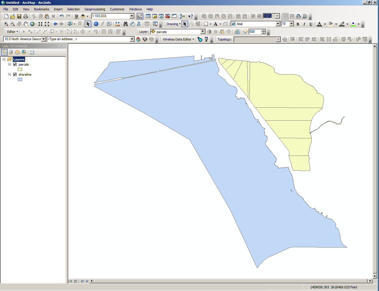
- Mark as New
- Bookmark
- Subscribe
- Mute
- Subscribe to RSS Feed
- Permalink
- Report Inappropriate Content
How many parcel-polygons does the 10% represent? You might just have to roll up your sleeves, and spend some time manually extending the coast line edge of those polygons so the extend past the actual coastline and then clip your parcels...