Turn on suggestions
Auto-suggest helps you quickly narrow down your search results by suggesting possible matches as you type.
Cancel
- Home
- :
- All Communities
- :
- Products
- :
- Data Management
- :
- Data Management Questions
- :
- Re: Address Points "bunched" for many roads
Options
- Subscribe to RSS Feed
- Mark Topic as New
- Mark Topic as Read
- Float this Topic for Current User
- Bookmark
- Subscribe
- Mute
- Printer Friendly Page
Address Points "bunched" for many roads
Subscribe
1099
4
06-07-2013 11:44 AM
06-07-2013
11:44 AM
- Mark as New
- Bookmark
- Subscribe
- Mute
- Subscribe to RSS Feed
- Permalink
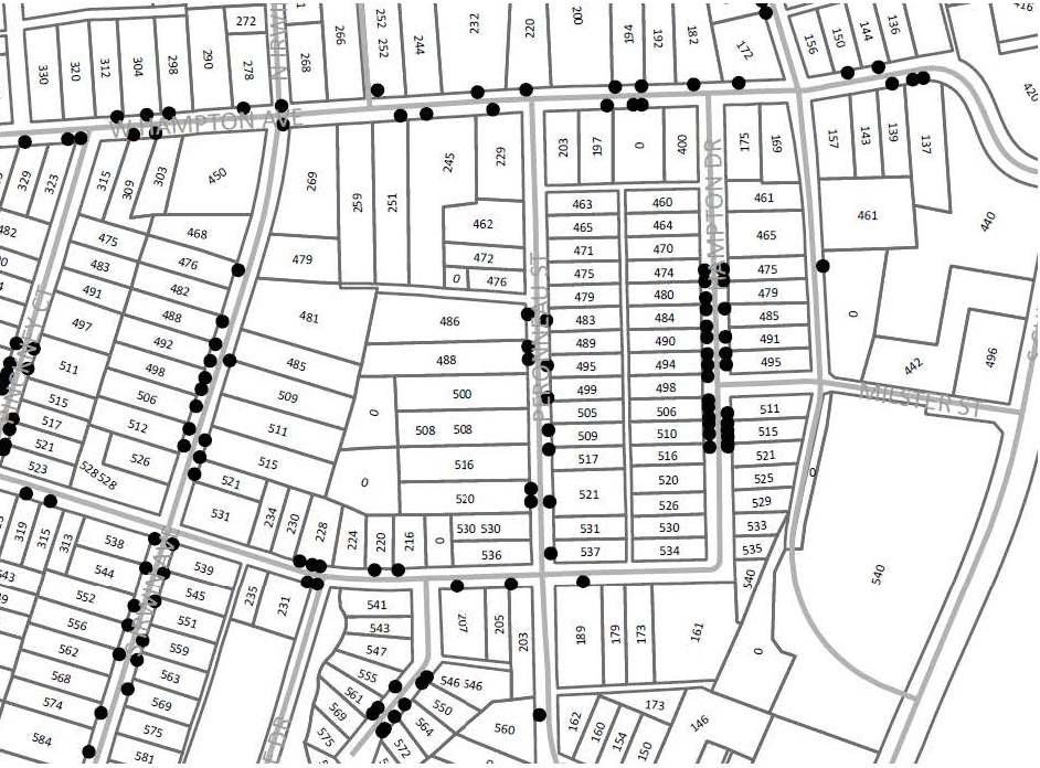
I'm trying to map recycle and garbage bins for our municipality. After geo-coding based off of the addresses, many of the address points are bunched on one side of the street. Some are put in front of the correct parcels for an entire street. I've attached a picture and pdf of a small section of the map created. [ATTACH=CONFIG]25135[/ATTACH]
4 Replies
06-10-2013
12:25 PM
- Mark as New
- Bookmark
- Subscribe
- Mute
- Subscribe to RSS Feed
- Permalink
When geocoding against a line, the process simply interpolates the location (x,y) of the given address based on the range of addresses for a given street and the length of the street.
As a very simple example, suppose you have a street called Main St and the 100 block is address ranged 101-199 on the odd side and 100-198 on the even side. This section of Main ST is 300 meters long. The address of 150 Main ST should fall on the even side of the street, at just about the middle of the block (approximately 150 meters from the intersections). Could be that the house is actually on the odd side of the street and at the far end of the block.
This can lead into a discussion of accuracy and precision; locating 150 Main St at the half way point is accurate; if you use GPS'd address points, they would much more precise as you would have occupied the driveway at 150 Main ST and recorded the actual x,y.
You have to decide how precise your data needs to be and the associated costs with that level of precision....
That should just about do it....
by
Anonymous User
Not applicable
06-10-2013
01:02 PM
- Mark as New
- Bookmark
- Subscribe
- Mute
- Subscribe to RSS Feed
- Permalink
Original User: Carpendr
Yeah, that's what I figured. I've been trying to make my own Address Locater, but have only messed with it a bit. Costs? I'm trying to keep that outta my workplans. I'll keep trying options out until I deem it futile, which will most likely be soon. I only need it to help the solid waste managers figure out routes based on cart count, and I'm going to try to persuade them to use the data anyway. Not like the presentation matters at this point.
Yeah, that's what I figured. I've been trying to make my own Address Locater, but have only messed with it a bit. Costs? I'm trying to keep that outta my workplans. I'll keep trying options out until I deem it futile, which will most likely be soon. I only need it to help the solid waste managers figure out routes based on cart count, and I'm going to try to persuade them to use the data anyway. Not like the presentation matters at this point.
06-11-2013
03:51 AM
- Mark as New
- Bookmark
- Subscribe
- Mute
- Subscribe to RSS Feed
- Permalink
Now that you have the demand points mapped sufficiently, take the next step and use network analysis to work the vehicle routing...
That should just about do it....
by
Anonymous User
Not applicable
06-11-2013
04:20 AM
- Mark as New
- Bookmark
- Subscribe
- Mute
- Subscribe to RSS Feed
- Permalink
Original User: Carpendr
That's the plan. Going to try it with the bus routes first. Less streets. I don't even know if I have the license for it. Going to find out.
That's the plan. Going to try it with the bus routes first. Less streets. I don't even know if I have the license for it. Going to find out.