- Home
- :
- All Communities
- :
- Products
- :
- ArcGIS Web AppBuilder
- :
- ArcGIS Web AppBuilder Questions
- :
- Re: Threat Analysis widget distance issues
- Subscribe to RSS Feed
- Mark Topic as New
- Mark Topic as Read
- Float this Topic for Current User
- Bookmark
- Subscribe
- Mute
- Printer Friendly Page
Threat Analysis widget distance issues
- Mark as New
- Bookmark
- Subscribe
- Mute
- Subscribe to RSS Feed
- Permalink
Hello there,
has someone tried the new threat analysis widget?
It seems to have some difficulties to show the correct evacuation distances. And it doesn't matter if I choose a default threat type or a custom threat type.
Please take a look at the screenshot:
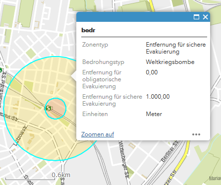
The safe evacuation distance (or radius) should be 1000 m but if you campare it to the scale bar you can clearly see that it's only about 600 m. I've tried it with some other threat types but none of these showed the correct distance.
Is there maybe a correlation to the projected coordinate system (WKID 25833) we use?
Or any other ideas?
Thanks
- Mark as New
- Bookmark
- Subscribe
- Mute
- Subscribe to RSS Feed
- Permalink
@WebGISGdibx This issue has been addressed in the latest release of the Threat Analysis widget. Distance calculations per threat type now take into account the projection of the basemap. Hope that helps.