- Home
- :
- All Communities
- :
- Products
- :
- ArcGIS Viewer for Flex (Retired)
- :
- ArcGIS Viewer for Flex Questions
- :
- Re: ArcGIS Viewer for Flex and Geoserver
- Subscribe to RSS Feed
- Mark Topic as New
- Mark Topic as Read
- Float this Topic for Current User
- Bookmark
- Subscribe
- Mute
- Printer Friendly Page
ArcGIS Viewer for Flex and Geoserver
- Mark as New
- Bookmark
- Subscribe
- Mute
- Subscribe to RSS Feed
- Permalink
Hi everybody,
I'm developing a thesis on WebGIS and I'm building some Web Map Applications to show the results.
I'm manipulating all the data in ArcGIS Desktop and I have experience with ArcGIS Server and ArcGIS Viewer for Flex. The thing is that know I don't have access to the university's ArcGIS Server and I'm developing everything on localhost, through GeoServer. The GeoServer is up and running, but I don't know how to add it to ArcGIS Viewer for Flex (3.6), something that is aggravated by the fact that I don’t know too much about .xml. I searched a lot, including here in GeoNet, and some people say it’s easier to add it in the config.xml, but I’m looking for more recent and simpler answers.
So, first, I want to know if it is possible to add the GeoServer service, for instance WMS, directly in ArcGIS Viewer for Flex interface. Secondly, where can I find the GeoServer link to a specific service, for example like adding ArcGIS Server operational layer in ArcGIS Viewer for Flex: http://server/arcgis/rest/services... ? I tried to connect through http://localhost:8080/geoserver/web http://localhost:8080/geoserver or even with the Service Capabilities from GeoServer and I tried everything in this thread https://community.esri.com/thread/44313 with no success. The maximum I got was ArcGIS Viewer for Flex asking me the GeoServer credentials…
Finally, if what I’m asking is not possible, then, I would like to know how to add a service from GeoServer in ArcGIS Viewer for Flex.
Thank you in advance,
Ricardo Silva
- Mark as New
- Bookmark
- Subscribe
- Mute
- Subscribe to RSS Feed
- Permalink
Ricardo,
It is definitely possible to add a wms from geo server to the flex viewer. You will probably have to do it by manually amending the xml file, you will add the layer as a wms layer type by adding the following:
<layer label="roads" type="wms" visible="true" skipgetcapabilities="true"
wkid="4326" format="image/png" visiblelayers="roads" version="1.1.1"
url="http://localhost:8080/geoserver/wms"/>
The visible layers tags needs to include the exact layer names of the layers you want to add
- Mark as New
- Bookmark
- Subscribe
- Mute
- Subscribe to RSS Feed
- Permalink
Hi Anthony,
Thanks for the quick answer. I had already try what you suggest and tried it again with no positive results. It must be something related with my config.xml because everything is working with GeoServer. I even had a WMS Server to ArcCatalog and I can see and manipulate the WMS layer in ArcGIS. So, check my config please, because I don't understand much about .xml:
<?xml version="1.0"?>
<configuration>
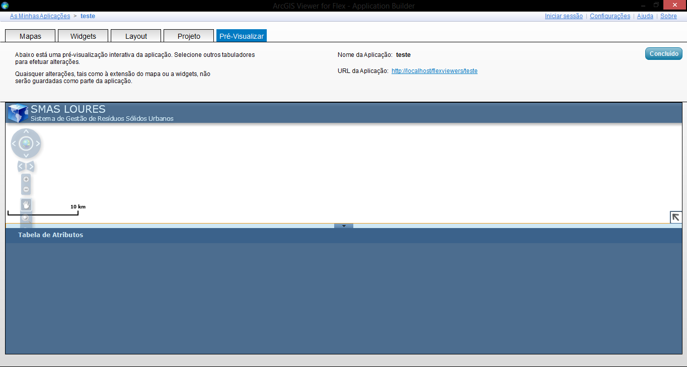
<title>SMAS LOURES</title>
<logo>assets/images/logo.png</logo>
<style>
<colors>0xcee7f4,0x39628c,0x355d89,0x294867,0xcee7f4</colors>
<alpha>0.8</alpha>
<font name="Verdana"/>
<titlefont name="Verdana"/>
<subtitlefont name="Verdana"/>
</style>
<!-- replace the following url with your own geometryservice -->
<geometryservice url="https://utility.arcgisonline.com/arcgis/rest/services/Geometry/GeometryServer"/> <subtitle>Sistema de Gestão de Resíduos Sólidos Urbanos</subtitle>
<widget url="widgets/Navigation/NavigationWidget.swf" top="50" left="10" config="widgets/Navigation/NavigationWidget.xml"/>
<widget url="widgets/OverviewMap/OverviewMapWidget.swf" config="widgets/OverviewMap/OverviewMapWidget.xml" bottom="0" right="0"/>
<widget url="widgets/MapSwitcher/MapSwitcherWidget.swf" top="55" config="widgets/MapSwitcher/MapSwitcherWidget.xml" right="20"/>
<widget url="widgets/HeaderController/HeaderControllerWidget.swf" top="0" left="0" config="widgets/HeaderController/HeaderControllerWidget.xml"/>
<map top="40" portalurl="https://www.arcgis.com/" wkid="102100" initialextent="-1065101.4568858757 4682867.22433295 -973759.2080852132 4719709.8719663555" addarcgisbasemaps="true" wraparound180="true" zoomslidervisible="false" scalebar="metric" scalebarvisible="true" openhandcursorvisible="false" esrilogovisible="false" attributionvisible="false">
<operationallayers>
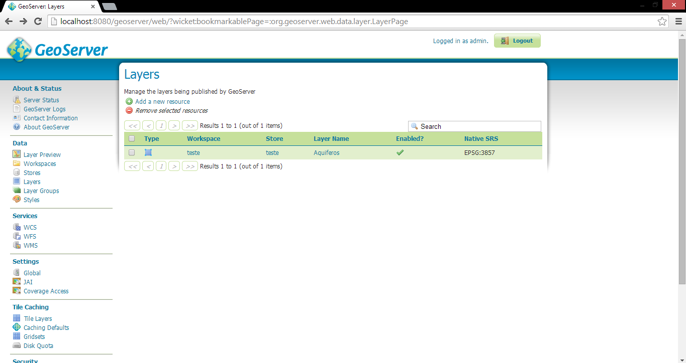
<layer url="http://localhost:8080/geoserver/wms" wkid="3857" version="1.1.1" visiblelayers="teste" format="image/png" skipgetcapabilities="true" visible="true" type="wms" label="teste"/>
</operationallayers>
</map>
<widgetcontainer layout="float"/>
<widgetcontainer initialstate="open" paneltype="bottom">
<widget url="widgets/AttributeTable/AttributeTableWidget.swf" config="widgets/AttributeTable/AttributeTableWidget.xml" label="Tabela de Atributos" icon="assets/images/TableOpen32.png"/>
</widgetcontainer>
</configuration>
I tried
<layer label="teste" type="wms" visible="true" skipgetcapabilities="true"
wkid="3857" format="image/png" visiblelayers="teste" version="1.1.1"
url="http://localhost:8080/geoserver/wms"/>
but it keeps changing it to what is on the top, everytime I close ArcGIS Viewer for Flex. And instead of "teste" as layer name I tried "Aquifero" too.
Here is my service:
And here is the result:
Thanks a lot. I really need this to end my Master.
- Mark as New
- Bookmark
- Subscribe
- Mute
- Subscribe to RSS Feed
- Permalink
Ricardo,
try typing http://localhost:8080/geoserver/wms?request=getcapabilities in your browser this should provide the capabilities for the wms, in here you will see the layer name you will need to use. It maybe be teste:Aquifero
you will not see any attributes in your attribute table as this is not supported for wms layers