- Home
- :
- All Communities
- :
- Developers
- :
- ArcGIS Pro SDK
- :
- ArcGIS Pro SDK Questions
- :
- Re: MapView.Extent is wrong on spatial reference c...
- Subscribe to RSS Feed
- Mark Topic as New
- Mark Topic as Read
- Float this Topic for Current User
- Bookmark
- Subscribe
- Mute
- Printer Friendly Page
MapView.Extent is wrong on spatial reference change
- Mark as New
- Bookmark
- Subscribe
- Mute
- Subscribe to RSS Feed
- Permalink
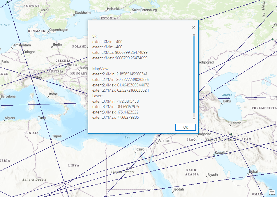
Code for test:
var sr = mapView.Map.SpatialReference;
var extent = mapView.Extent;Steps to reproduce the problem:
1. Create new project. Variables now will have values:
2. Add layer with WGS84 spatial reference and zoom to full extent (the issue will be without zooming too). Now execute the code above:
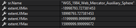
We see that spatial reference now is WGS84, but extent coordinates doesn't correspond to WGS84. Max extent for this sr must be -180 -90 180 90 in degrees, but the values from screenshot are obviously wrong.
More than that I can't project extent to WGS84, because it's already in WGS84, so coordinates still the same!
Solved! Go to Solution.
Accepted Solutions
- Mark as New
- Bookmark
- Subscribe
- Mute
- Subscribe to RSS Feed
- Permalink
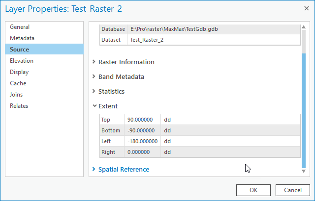
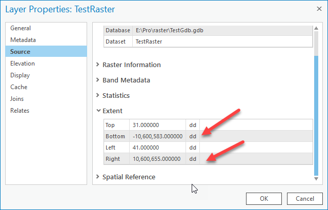
Max, the issue to me looks like you are not specifying a cell size. The resulting cell size of the raster is 10600614 which matches the dimension of the raster. I do not know the significance of that number (i.e. why is it used as the default cell size). However, if I do specify a cell size explicitly (eg "90" or "180" ) then the extent of the layer is correct (as, in, it is a proper extent).
As the cell size, in this case because of the projection being used, is in decimal degrees and the WGS projection is wider than it is tall, I assume that the maximum possible cell size will be "180" while still retaining a "real" spatial extent.
For example, using your same settings and a cell size of 180:
- Mark as New
- Bookmark
- Subscribe
- Mute
- Subscribe to RSS Feed
- Permalink
Any news on this issue?
- Mark as New
- Bookmark
- Subscribe
- Mute
- Subscribe to RSS Feed
- Permalink
I cannot reproduce. My results using 2.4:
SR Domain, MapView Extent, layer "QueryExtent"
Initial extent:
Zoom to layer extent
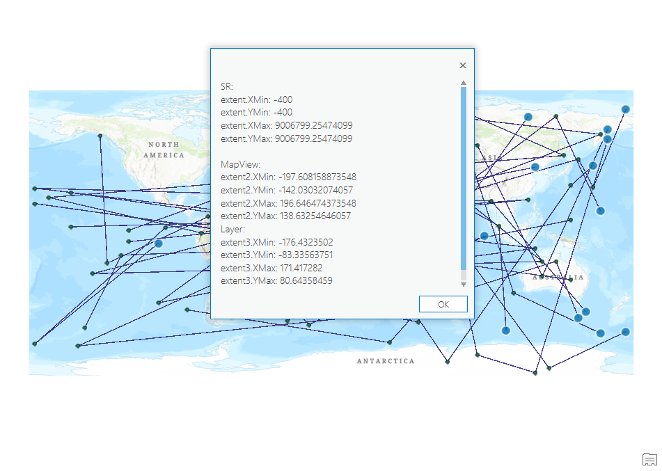
Pan to date line (or approx) with "Enable wrapping around the date line" enabled
layer properties:
map properties:
- Mark as New
- Bookmark
- Subscribe
- Mute
- Subscribe to RSS Feed
- Permalink
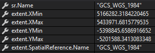
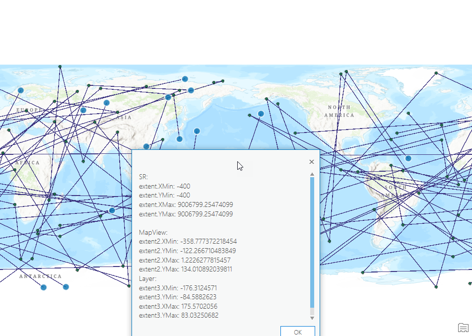
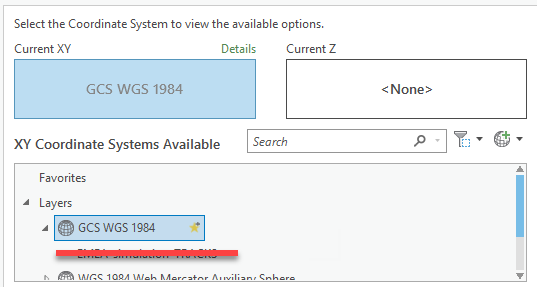
Hi Charles,
I found exact scenario to reproduce issue. I suppose you added feature layer with WGS84 and all is OK. Yes, in this case I see valid values too.
But if I add raster dataset with WGS84 to new project, values will be invalid:

I've attached zip archive with GDB with raster dataset to my question.
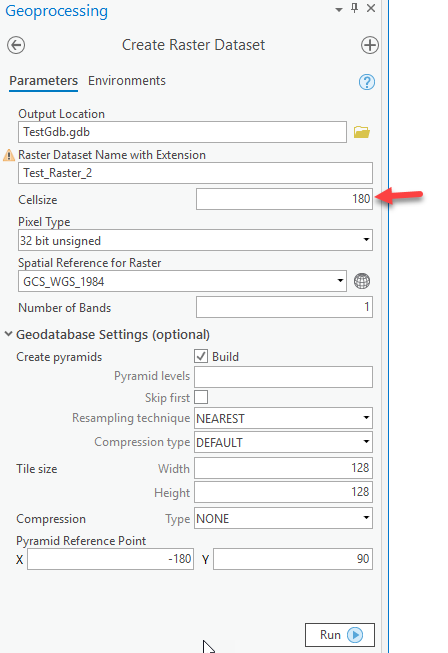
Raster dataset created with this code:
var fullExtent = await QueuedTask.Run(() => EnvelopeBuilder.CreateEnvelope(-180, -90, 180, 90, SpatialReferences.WGS84));
var args = Geoprocessing.MakeValueArray(datastorePath, RasterDatasetName, null, "32_BIT_UNSIGNED", null, 1, null, "NONE");
var env = Geoprocessing.MakeEnvironmentArray(outputCoordinateSystem: SpatialReferences.WGS84, extent: fullExtent);
var gpResult = await Geoprocessing.ExecuteToolAsync("CreateRasterDataset_management", args, env, cancellationToken, flags: GPExecuteToolFlags.AddOutputsToMap);- Mark as New
- Bookmark
- Subscribe
- Mute
- Subscribe to RSS Feed
- Permalink
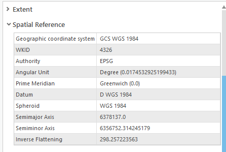
Hi Max, the layer extent looks bogus:
- Mark as New
- Bookmark
- Subscribe
- Mute
- Subscribe to RSS Feed
- Permalink
OK, but it has been created with Create Raster Dataset tool, so dataset is created in legitimate way. Is it a bug in Create Raster Dataset geoprocessing tool? How can I create valid raster dataset in GDB?
- Mark as New
- Bookmark
- Subscribe
- Mute
- Subscribe to RSS Feed
- Permalink
I've also checked Create Raster Dataset for GDB and file rasters, and in all cases output dataset has such strange extent. Please give advice how can I create valid raster dataset with valid extent for WGS84?
- Mark as New
- Bookmark
- Subscribe
- Mute
- Subscribe to RSS Feed
- Permalink
Max, the issue to me looks like you are not specifying a cell size. The resulting cell size of the raster is 10600614 which matches the dimension of the raster. I do not know the significance of that number (i.e. why is it used as the default cell size). However, if I do specify a cell size explicitly (eg "90" or "180" ) then the extent of the layer is correct (as, in, it is a proper extent).
As the cell size, in this case because of the projection being used, is in decimal degrees and the WGS projection is wider than it is tall, I assume that the maximum possible cell size will be "180" while still retaining a "real" spatial extent.
For example, using your same settings and a cell size of 180:
- Mark as New
- Bookmark
- Subscribe
- Mute
- Subscribe to RSS Feed
- Permalink
Thanks, that works! Quite strange behavior since cell size is optional parameter.