- Home
- :
- All Communities
- :
- Products
- :
- ArcGIS Pro
- :
- ArcGIS Pro Questions
- :
- Layout view shifts map clip in ArcGIS Pro but in m...
- Subscribe to RSS Feed
- Mark Topic as New
- Mark Topic as Read
- Float this Topic for Current User
- Bookmark
- Subscribe
- Mute
- Printer Friendly Page
Layout view shifts map clip in ArcGIS Pro but in map view layers overlay perfectly?
- Mark as New
- Bookmark
- Subscribe
- Mute
- Subscribe to RSS Feed
- Permalink
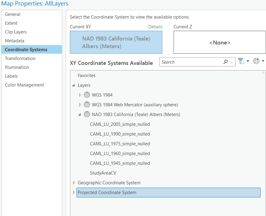
I am using ArcGIS Pro 2.8.2 to overlay many layers - raster, polygon and point. In map view when I overlay the layers, they line up perfectly (see screenshot). But when I make a layout showing the individual layers, the layer containing point data is slightly shifted (see layout screenshot how first clip does not line up with the next two). The map coordinate system is in NAD 1983 California Teale Albers. I've attached some screenshots. I did not define a projection for the point layer. Thank you for any help!
Solved! Go to Solution.
Accepted Solutions
- Mark as New
- Bookmark
- Subscribe
- Mute
- Subscribe to RSS Feed
- Permalink
What are the coordinate systems actually?
You never "define" a coordinate system unless a featureclass doesn't have one defined. And if it doesn't have a defined coordinate system, then one needs to be defined or nothing will line up.
Use the Project tool to get everything in a known desired coordinate system, rather than relying on project-on-the-fly if that is what you are doing.
And if the data still don't line up properly, then one of the coordinate systems has been defined incorrectly
... sort of retired...
- Mark as New
- Bookmark
- Subscribe
- Mute
- Subscribe to RSS Feed
- Permalink
Yes - thank you again. Sorry for posting so similar to my last post but I wasn't understanding the coordinate system versus the projection. I think I've got it now. THANK YOU.
- Mark as New
- Bookmark
- Subscribe
- Mute
- Subscribe to RSS Feed
- Permalink
Yes - I am relying on project-on-the-fly. I thought that was the preferred method.
The Geographic coordinate system for the point layer is WGS 1984.
The Projected coordinate system for the rasters are: NAD 1983 California (Teale) Albers (Meters).