- Home
- :
- All Communities
- :
- Products
- :
- ArcGIS Pro
- :
- ArcGIS Pro Questions
- :
- Re: Landsat8Imagery in ArcGIS Pro
- Subscribe to RSS Feed
- Mark Topic as New
- Mark Topic as Read
- Float this Topic for Current User
- Bookmark
- Subscribe
- Mute
- Printer Friendly Page
- Mark as New
- Bookmark
- Subscribe
- Mute
- Subscribe to RSS Feed
- Permalink
I am having problems working with land sat8 imagery in ArcGIS Pro. I keep on getting this image (see attached) and I can't do my land classification with this. Please can any one help.
Thanks
Solved! Go to Solution.
Accepted Solutions
- Mark as New
- Bookmark
- Subscribe
- Mute
- Subscribe to RSS Feed
- Permalink
The Band Composite parameters look fine.
Do the individual bands display correctly in ArcGIS Pro?
If they do, then in the composite layer change the band combination to
For True Color Composite
Red Channel: Band 4
Green Channel: Band 3
Blue Channel: Band 2
For Standard False Color Composite
Red Channel: Band 5
Green Channel: Band 4
Blue Channel: Band 3

Think Location
- Mark as New
- Bookmark
- Subscribe
- Mute
- Subscribe to RSS Feed
- Permalink
Was this the original landsat image?
Did you add it to an empty map? (eg no topographic layer)
What are the image properties?
... sort of retired...
- Mark as New
- Bookmark
- Subscribe
- Mute
- Subscribe to RSS Feed
- Permalink
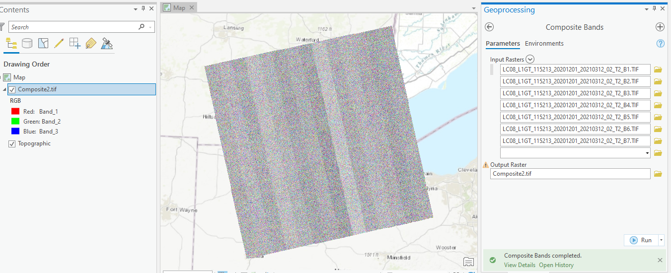
Do you have the individual band rasters? Landsat 8 band designations (usgs.gov)
What bands were used while creating the composite, and in what order?
Please share the screenshot of the parameters used in Composite Bands tool.
Think Location
- Mark as New
- Bookmark
- Subscribe
- Mute
- Subscribe to RSS Feed
- Permalink
The Band Composite parameters look fine.
Do the individual bands display correctly in ArcGIS Pro?
If they do, then in the composite layer change the band combination to
For True Color Composite
Red Channel: Band 4
Green Channel: Band 3
Blue Channel: Band 2
For Standard False Color Composite
Red Channel: Band 5
Green Channel: Band 4
Blue Channel: Band 3
Think Location
- Mark as New
- Bookmark
- Subscribe
- Mute
- Subscribe to RSS Feed
- Permalink
Thanks.
- Mark as New
- Bookmark
- Subscribe
- Mute
- Subscribe to RSS Feed
- Permalink
If it is the original landsat image, it would already be composite bands.
Why would you run the tool if it already had 3 or more bands? (it has 7 bands now)
Composite Bands (Data Management)—ArcGIS Pro | Documentation
Is this the original image? not the one with composite bands run on it.
... sort of retired...
- Mark as New
- Bookmark
- Subscribe
- Mute
- Subscribe to RSS Feed
- Permalink
ahhhh no wonder it looks strange to me
Landsat 8 bands 4, 3, and 2 correspond to the red, green, and blue portions of the visible spectrum.
Elegant Figures - How To Make a True-Color Landsat 8 Image (nasa.gov)
Landsat 8 – Natural color (shadedrelief.com)
... sort of retired...