- Home
- :
- All Communities
- :
- Products
- :
- ArcGIS Pro
- :
- ArcGIS Pro Questions
- :
- Re: How to dissolve symbol boundaries between poly...
- Subscribe to RSS Feed
- Mark Topic as New
- Mark Topic as Read
- Float this Topic for Current User
- Bookmark
- Subscribe
- Mute
- Printer Friendly Page
How to dissolve symbol boundaries between polygons in ArcPro?
- Mark as New
- Bookmark
- Subscribe
- Mute
- Subscribe to RSS Feed
- Permalink
There is a cartographic technique in ArcMap that can dissolve the boundaries between polygons with the same symbol without actually the need for dissolving the geometries into another dataset, this is documented in the help as well as this blog here.
In ArcPro help it says here
Eliminate county boundaries between polygon areas by state by setting Join and Merge on multiple polygon symbol classes.
but then gives no guidance on how to do it! I've searched various ESRI sub-sites and have found no walk through. As Pro is sufficiently different to ArcMap I can't work how to do it! Does anyone know of a walk through or can provide a step-by-step guide?
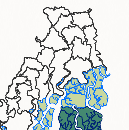
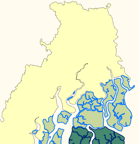
In my dataset below I want to dissolve the internal boundaries of the black polygons so they create a simple outline, whilst the other green polygons remain as they are.
Kory Kramer - tagging you as you are the Master of ArcPro! I would really appreciate any help on this!
- Mark as New
- Bookmark
- Subscribe
- Mute
- Subscribe to RSS Feed
- Permalink
Here is a link to something similar. It seems the Symbol Layer Drawing option is what you are looking for.
- Mark as New
- Bookmark
- Subscribe
- Mute
- Subscribe to RSS Feed
- Permalink
I just attempted to do this and it seems like it will probably work, but you are going to have a hard time if there are a lot of layers. There seems to be a bug where if you click "Format all symbols", under "Properties", the "Layers" and "Structure" options are non-existent. If I figure it out I will let you know. Ken Field I think the linked blog was yours, do you have any ideas for Pro?
- Mark as New
- Bookmark
- Subscribe
- Mute
- Subscribe to RSS Feed
- Permalink
I did actually end up at that page before I posted here, but found it of no use as it seemed to be principally talking about roads (polylines) and I could not work out how to do it with polygons. If you check out the ArcMap blog they talk about creating new symbol layers and clicking on locks (not sure why) and then setting merge/join. I have been totally unsuccessful in transferring that ArcMap workflow to Pro hence me come with a begging bowl!
- Mark as New
- Bookmark
- Subscribe
- Mute
- Subscribe to RSS Feed
- Permalink
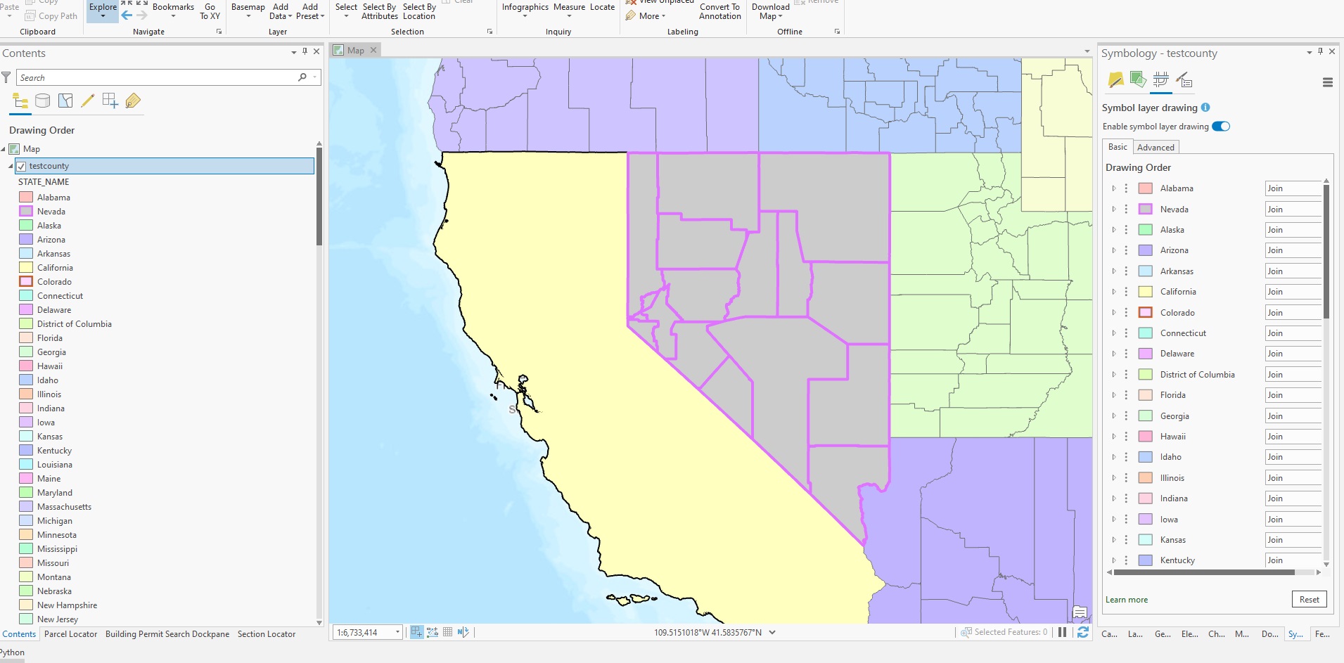
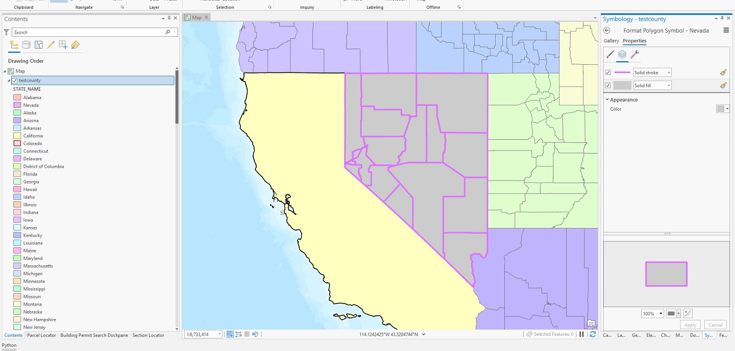
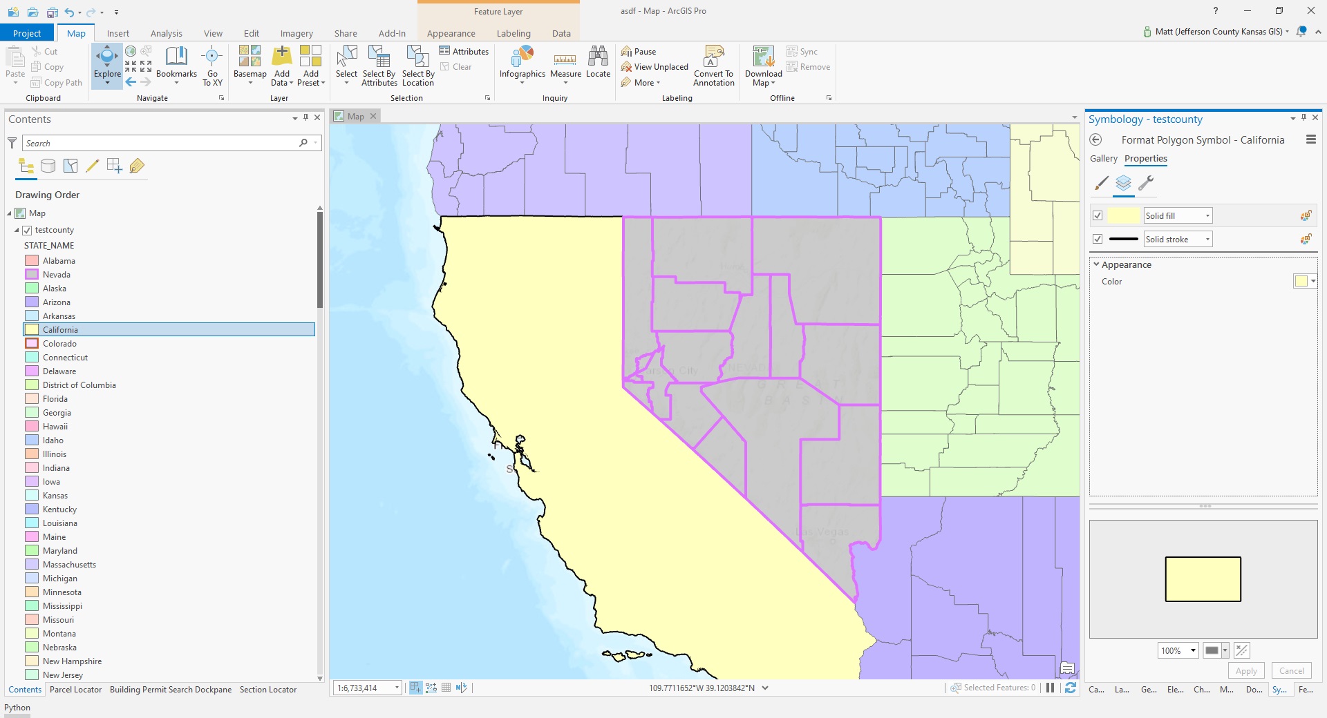
For your case it is just a matter of how you layer your symbology layers. You will need to Enable symbol layer drawings with just Join. Example is for California and Nevada as two different classes and symbology to focus on. Notice on Nevada the Solid stroke is on top and California it's on bottom.
Enable symbol layer:
- Mark as New
- Bookmark
- Subscribe
- Mute
- Subscribe to RSS Feed
- Permalink
Hi Matthew,
Appreciate your help. Reading your answer, going back to arcmap then re reading your answer I finally achieved a partial success in that I was able to dissolve / hide the boundaries by moving the solid fill above the solid stroke, a screen shot is shown below...but...
I was only able to achieve this if I set the fill symbol to solid with a colour (in my test, yellow). In my original question the "white" polygons were in fact polygons with their fill set to no colour. So does this cartographic effect only work for layers where the polygons have a fill colour, like your USA state example?
- Mark as New
- Bookmark
- Subscribe
- Mute
- Subscribe to RSS Feed
- Permalink
I don't know, it does not seem no color will work for this in Pro. The problem is, for what ever reason, in Pro they don't have polygons for symbology of POLYGONS, its fill with no outline. Weird huh. So you have no true outlines in the ArcMap equivlent, just something they call "solid stroke". The more I come across this stuff the more I am convinced the Pro development team had more of a CAD background. Add the tag "arcmap equivalent" to your original post to get more eyes on this.
- Mark as New
- Bookmark
- Subscribe
- Mute
- Subscribe to RSS Feed
- Permalink
Is there a reason setting the fill to white will not work?
- Mark as New
- Bookmark
- Subscribe
- Mute
- Subscribe to RSS Feed
- Permalink
Yeah, to simplify the image for asking this question I turned off another layer that needs to be showing through the transparent polygons. For expedience I fell back to dissolving the geometries into another layer to create the bounding polygon. But this is something I know I will encounter again, I often need to show data through administrative boundaries. Would be great to know if dissolving boundaries with polygons that have no fill can actually be done and if so what steps need to be taken.
- Mark as New
- Bookmark
- Subscribe
- Mute
- Subscribe to RSS Feed
- Permalink
I figured out a way to do this in Pro after some experimentation...
1. Select the features you would like to symbolize with just a boundary. Right click the layer in the contents pane and click "Make Layer From Selected Feature"
2. Change the symbology in original layer to show nothing - no color stroke or fill layer.
3. Change the symbology in the layer created from the selected features to the outline you want.
4. Highlight the layer created from the selected features. Under the Appearance tab in the Drawing group, expand Masking and select the original layer. This will mask all of the internal boundaries.