- Home
- :
- All Communities
- :
- Products
- :
- ArcGIS Pro
- :
- ArcGIS Pro Questions
- :
- Re: Geodatabase connection properties ERROR
- Subscribe to RSS Feed
- Mark Topic as New
- Mark Topic as Read
- Float this Topic for Current User
- Bookmark
- Subscribe
- Mute
- Printer Friendly Page
Geodatabase connection properties ERROR
- Mark as New
- Bookmark
- Subscribe
- Mute
- Subscribe to RSS Feed
- Permalink
- Report Inappropriate Content
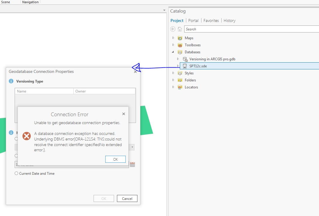
I’m using ARCGis Pro 2.2.2 connecting to Oracle 12.1.0.1.0 to enterprise Geodatabase 10.2 and I’m getting below error when I try to view Geodatabase connection properties .
Although I mange to connect to the geodatabase .
- Mark as New
- Bookmark
- Subscribe
- Mute
- Subscribe to RSS Feed
- Permalink
- Report Inappropriate Content
Jonathan, I should have clarified. All of my testing was done using Operating System Authentication (OSA).
Answers to your questions:
- Yes, we are using OSA, and Easy Connect hangs when trying to access Geodatabase Connection Properties
- For our implementation, Easy Connect with database authentication (schema owner DB user) also hangs.
- When username and password is not saved, I get an error. The odd part, I got the error before it even asked me for a username and password.
- Connection Error: Unable to get geodatabase connection properties.
- A database connection exception has occured. Underlying DBMS did not accept username/passowrd.
- Connection Error: Unable to get geodatabase connection properties.
For our implementation, what we have found is that all of the errors are generated when "SDE" is selected as the schema geodatabase, which is the default when the Create Database Connection dialog. If we use the Create Database Connection geoprocessing tool and pre-set a schema other than "SDE", then TNSNAMES and LDAP works fine for seeing and changing Geodatabase Connection Properties. Oddly, Easy Connect still has issues.
- Mark as New
- Bookmark
- Subscribe
- Mute
- Subscribe to RSS Feed
- Permalink
- Report Inappropriate Content
What version of SDE are you using as you mention Enterprise Geodatabase 10.2?
- Mark as New
- Bookmark
- Subscribe
- Mute
- Subscribe to RSS Feed
- Permalink
- Report Inappropriate Content
Micheal.
we are using SDE 10.2.2 ... , is this can cause the problem ?
- Mark as New
- Bookmark
- Subscribe
- Mute
- Subscribe to RSS Feed
- Permalink
- Report Inappropriate Content
I don't think so as I get the same error when using SDE 10.5.1 with all applicable patches. I'm just thinking you might want to bring your SDE database up to a more current version as 10.2.x is getting dated at this point, but this is probably not a trivial task.
Is your org also using ArcMap? If so, what version are you using for ArcMap?
- « Previous
-
- 1
- 2
- Next »
- « Previous
-
- 1
- 2
- Next »