- Home
- :
- All Communities
- :
- Products
- :
- ArcGIS Pro
- :
- ArcGIS Pro Questions
- :
- Re: Feature to Raster
- Subscribe to RSS Feed
- Mark Topic as New
- Mark Topic as Read
- Float this Topic for Current User
- Bookmark
- Subscribe
- Mute
- Printer Friendly Page
- Mark as New
- Bookmark
- Subscribe
- Mute
- Subscribe to RSS Feed
- Permalink
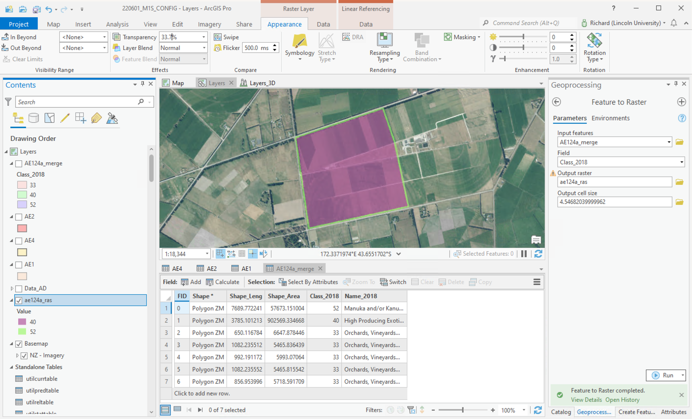
Hi
I am trying to convert a feature layer to a raster. The feature layer contains 3 classes, but only 2 of the classes are converting across to the raster. Please see attached (one image showing the resulting purple raster, the other showing the feature class (AE4) that is not converting.
Any pointers much appreciated. This follows a previous issue with merging feature layers, that came up with layer I'm now trying to convert to a raster @DanPatterson
Cheers, Richard
Solved! Go to Solution.
Accepted Solutions
- Mark as New
- Bookmark
- Subscribe
- Mute
- Subscribe to RSS Feed
- Permalink
How to change NoData cells to a value—ArcGIS Pro | Documentation
raster calculator
syntax, means if the area surrounding the squiggles is nodata, assign the values from the other raster, else, use the orchards
Con(IsNull("orchards"), "other_raster", "orchards")
... sort of retired...
- Mark as New
- Bookmark
- Subscribe
- Mute
- Subscribe to RSS Feed
- Permalink
When you merged the orchards (the multipart features were merged last), you now have overlapping polygons,
Remove Overlap (multiple) (Analysis)—ArcGIS Pro | Documentation
should "burn" the orchards into the surrounding landscape, if not examine some of the overlay tools (like update) to get what you need prior to converting to raster.
An alternative would be to combine two rasters (orchards and the other)
... sort of retired...
- Mark as New
- Bookmark
- Subscribe
- Mute
- Subscribe to RSS Feed
- Permalink
Hi Dan - thanks, but when I try Remove Overlap the error message tells me that the Geometry cannot have Z-values. Previously, when merging these features, I had changed the Elevation properties for these features to 'On the ground. I assumed this had flattened them i.e. removed Z-values. Online instructions about removing Z-values talk about changing the GDB... would appreciate hearing if there are any quicker ways to deal with this.
Thanks, Richard
- Mark as New
- Bookmark
- Subscribe
- Mute
- Subscribe to RSS Feed
- Permalink
is class 33 obscured by class 40, i.e do you have overlapping polygons?, or
is the raster cell too large to show class 33?
...and have you looked at rather using PolygonToRaster?
- Mark as New
- Bookmark
- Subscribe
- Mute
- Subscribe to RSS Feed
- Permalink
Hi Steve
I tried these two suggested options, thanks. The PolygontoRaster options yields the same result (ie: AE4 not included). The raster cell size should be fine - the minimum width of the polygon is c. 7m. I tried the cell size at 1m to check, but still the same result.
Any other suggestions much appreciated.
- Mark as New
- Bookmark
- Subscribe
- Mute
- Subscribe to RSS Feed
- Permalink
but does the cell center of the raster cell fall within class 40?
Try using a priority field (PolygonToRaster) and specify positive values for class 40, see Maximum area method
- Mark as New
- Bookmark
- Subscribe
- Mute
- Subscribe to RSS Feed
- Permalink
The cells must fit within the squiggle orchards. what is the width of those? Your cell size should be at least 1/2 the average width if you have any chance of retaining those features (my rule of thumb).
... sort of retired...
- Mark as New
- Bookmark
- Subscribe
- Mute
- Subscribe to RSS Feed
- Permalink
Thanks
They squiggle orchards min width c. 7m; I tried 1m cell size but the result was the same.
- Mark as New
- Bookmark
- Subscribe
- Mute
- Subscribe to RSS Feed
- Permalink
You didn't try....
An alternative would be to combine two rasters (orchards and the other)
using the same cell size, extent and alignment, then combining them with the Con statement
... sort of retired...