- Home
- :
- All Communities
- :
- Products
- :
- ArcGIS Pro
- :
- ArcGIS Pro Questions
- :
- Re: Cannot orient layout frame grid labels properl...
- Subscribe to RSS Feed
- Mark Topic as New
- Mark Topic as Read
- Float this Topic for Current User
- Bookmark
- Subscribe
- Mute
- Printer Friendly Page
Cannot orient layout frame grid labels properly on rotated frame.
- Mark as New
- Bookmark
- Subscribe
- Mute
- Subscribe to RSS Feed
- Permalink
Hi,
I am trying to create a map series following a linear feature, with each page rotating to a set value.
This has worked fine, however previously in Arcmap I would have all of the grid labels on the X axis oriented horizontally and those on the Y axis oriented Vertically (to maximize space for the data frame).
In ArcGIS Pro this option seems to be related to whether the label is on an E,W,N or S grid line , rather than top,bottom,left or right axis ... and as such seems to be producing odd results, that I cannot rectify:
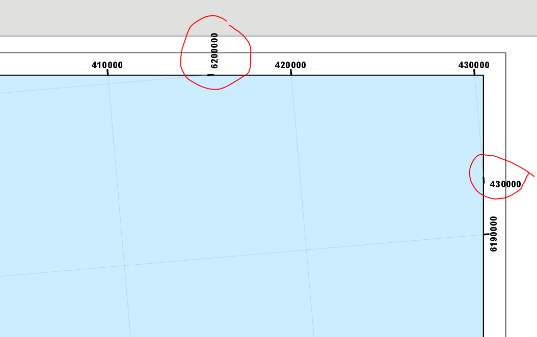
Ideally, as in ArcMap, i would want these labeled to automatically be oriented in line with the frame border ... not the same as the other labels of the same oriented grid-lines.
I don't think that coverting to graphics is an option as I assume this will not work with a map series.
If anyone has any ideas on this, they would be greatly appreciated !
Loz.
- Mark as New
- Bookmark
- Subscribe
- Mute
- Subscribe to RSS Feed
- Permalink
Yes, it is a bit frustrating. I'm not really in a position where I can remove the girds entirely. I presume you haven't found a solution to this since your message ?
Thanks
- Mark as New
- Bookmark
- Subscribe
- Mute
- Subscribe to RSS Feed
- Permalink
As of ver 2.2.2 this still seems to be an issue ? Has anyone found a solution yet ?
Thanks
- Mark as New
- Bookmark
- Subscribe
- Mute
- Subscribe to RSS Feed
- Permalink
Hi Lawrence,
At version 2.2 you can further customize grid and graticule label visibility as you see fit. In order to do what you are looking to do you will need to define your edges and specify the label orientation for each direction for each edge. You may want to consider creating a grid style once you have what you want in case you want to reuse this for other similarly rotated maps.
For a similar GeoNet discussion please see Gradicule Labels and Tick Marks in ArcGIS 2.2. Here is the help topic that should provide additional information - Add and modify graticules—Layouts | ArcGIS Desktop.
Hope this helps,
Tom
- Mark as New
- Bookmark
- Subscribe
- Mute
- Subscribe to RSS Feed
- Permalink
Hi Tom,
Thanks for the response. I think this allows me to produce something similar to what I had before (although not identical) .. but certainly means I can produce something fit for using, prior to what I had managed before !
Thanks again
- Mark as New
- Bookmark
- Subscribe
- Mute
- Subscribe to RSS Feed
- Permalink
Today with ArcPro v2.5 I have a new problem related to this. I have a map series of about a hundred pages. About 15 of those I have set to rotate 90 degrees. I have the grid labels set that they are aligned to the map frame (top and bottom the labels are horizontal; left and right the labels are vertical). However when I view one of these 15 rotated pages, the grid label text is no longer aligned with the map frame (now top and bottom the labels are vertical; left and right the labels are horizontal). That is a problem where I cannot convert to graphics due to the map series. I will have to turn off grid text to export maps. I haven't yet found a setting to check/change to prevent this.
- Mark as New
- Bookmark
- Subscribe
- Mute
- Subscribe to RSS Feed
- Permalink
Hi Aaron,
Currently map grid properties are not able to be configured for individual (or groups) of map series pages (unlike some map properties such as rotation and spatial reference). In order to achieve the affect you want you will need to create 2 separate layouts - one with the 90 degree rotation and one without and use ArcPy.mp to create the finished product
Introduction to arcpy.mp—ArcPy | Documentation.
MapSeries—ArcPy | Documentation
Hope this helps,
Tom
- Mark as New
- Bookmark
- Subscribe
- Mute
- Subscribe to RSS Feed
- Permalink
Tom,
Thanks, but map series with grids do not work this way in ArcMap - rotating the map doesn't change the orientation of grid labels. Again lot more work to do in ArcGIS Pro for something that is available in ArcMap.
- Mark as New
- Bookmark
- Subscribe
- Mute
- Subscribe to RSS Feed
- Permalink
Aaron,
Regarding the managing the visibility of grid labels, ArcMap does NOT provide any functionality that is not available in ArcGIS Pro.
I had assumed that with different pages in the map series you wanted different labels to display. For example, in created a map book with facing pages you may want the maps for “left side” pages to display the grid labels on the left side of the page, while for “right-side” pages you want the grid labels to display on the right side of the page.
Neither ArcMap, not ArcGIS Pro provide this ability outside the box. You would have to use ArcPy.
Perhaps this is not your workflow. Perhaps by “… orientation of grid labels” you are looking to have only the labels appear for the top and left side of the page. In ArcMap you would toggle the visibility of the Label Axes in the grid properties dialog like so:

Here is an example of 2 map series pages of US states where Hawaii has a map rotation of 0 and California has a map rotation of 90.
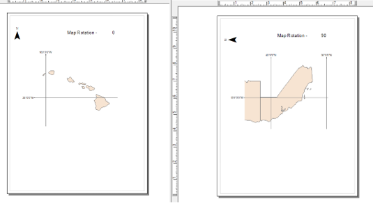
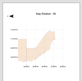
This can also be accomplished using ArcGIS Pro. If you are importing an MXD, like the one above, you will likely need to make some adjustments in Pro. For example, importing this MXD results in this for the California page.
Obviously, this is not what it looks like in ArcMap. There is a reason for this. When this MXD is imported into ArcGIS Pro you should get a notification. Click the blue dot to see the notification.
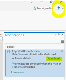
In this case there is a warning that modifications to the grid or graticule may be needed.

In this case ArcGIS Pro is not reading the “Top, Left, Bottom, Right” settings. This concept is different in ArcMap than it is in Pro. With ArcMap, you are restricted to the 4 sides of a page. With Pro, this restriction is removed. For instance, if you reshape a map or map frame so that there are more than 4 edges to the map ArcGIS provides a way to manage the labels for every edge.
For example, here is a reshaped map frame for Hawaii.
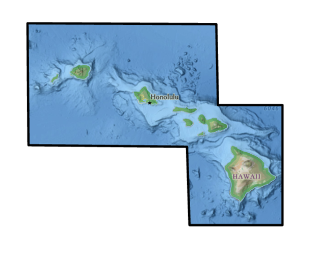
There are 8 edges, along with 8 corners. With ArcGIS Pro I can manages the grid labels for each.
You CANNOT do this in ArcMap.
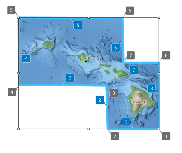
Back to the map imported above, the first step is to define the map grid edges and preview them so we can see the edge numbers we want to work with. For illustration purposes I don’t have labels on in the screenshot.

If it is the top and right edges of the map frame that I want to display labels I need to toggle the visibility for those edges. In this case I want to have the labels on for edges 1 and 1, and off for edges 3 and 4. From the Components tab in the Format Map Grid pane select Labels from the component list and under the Visible group click the Selected button.

Depending on your map rotation values you may not want to toggle all of the “North”, “South”… labels. In the example below edge 1 displays labels for both X and Y (Lat and Long).

In order to longitude labels along edge 1 I would toggle only “North” and “South”. For edge 2 I turned only “East” and “West” only.

For more information on this please see MGRS grids—Layouts | Documentation - and search for "Define map grid edges".
Hope this helps,
Tom