- Home
- :
- All Communities
- :
- Products
- :
- ArcGIS Pro
- :
- ArcGIS Pro Questions
- :
- Re: Can ArcGIS Pro import coverages (.adf files)?
- Subscribe to RSS Feed
- Mark Topic as New
- Mark Topic as Read
- Float this Topic for Current User
- Bookmark
- Subscribe
- Mute
- Printer Friendly Page
Can ArcGIS Pro import coverages (.adf files)?
- Mark as New
- Bookmark
- Subscribe
- Mute
- Subscribe to RSS Feed
- Permalink
I haven't been able to find any information related to how coverage files are treated in ArcGIS Pro - other than they don't seem to show up properly in the Project pane when I connect to my data directory. Is there an import tool I've overlooked or should I take this to mean coverages aren't supported in Pro? If they are not, is there a plan to support coverages in the future?
- Mark as New
- Bookmark
- Subscribe
- Mute
- Subscribe to RSS Feed
- Permalink
True.
But this is all very helpful indeed.
I talked with Steve L above and it truly does work! The only semi-funky thing is that you have to go to Windows explorer, copy the whole desired path to TEXT, then in ArcGIS Pro, paste that whole string in to the copy features box before selecting the geometry type. But that's a minor thing - I'm very thankful to everyone that it works!
But yes, as Curtis says, my students/faculty/ in my workshops still encounter e00s so a Script would be FANTASTIC. For years for example I ran Bruce Ralston's SDTS (yes, SDTS) to shapefile program but you had to run it outside of ArcGIS, and so it would be much better to have a e00 to feature class or coverage script... someday... please. Thanks so much,
--Joseph Kerski
- Mark as New
- Bookmark
- Subscribe
- Mute
- Subscribe to RSS Feed
- Permalink
Sorry... I spoke too soon. I thought it had worked but it turned out that my results are all EMPTY feature classes. Argh! I was soooo close and so excited about this.
- Mark as New
- Bookmark
- Subscribe
- Mute
- Subscribe to RSS Feed
- Permalink
I tried as shp as well - empty.
- Mark as New
- Bookmark
- Subscribe
- Mute
- Subscribe to RSS Feed
- Permalink
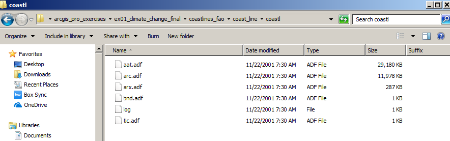
Update - I can't claim credit - it was Steve Lynch who helped me figure this out - Thank you Steve! ... my sorrow has turned into joy - what you need to do is actually type IN the geometry of your data - so in my case, for example, for coastlines stored as an ArcInfo coverage:
C:\temp\josephK\coast_line\coastl\arc
And remember to do what I mentioned above - use copy to text - for your whole pathname. It is very important to be at the correct position in your path - you need to be AT the level where you are seeing the ADF coverage files ... see below:

--Joseph Kerski
- Mark as New
- Bookmark
- Subscribe
- Mute
- Subscribe to RSS Feed
- Permalink
Pro's arcpy can totally see the coverages, they just don't show up in the GUI.
I imported a e00 using Desktop's import71.exe .e00 as ag_chem_cov and arcpy can see its components (arcpy sees a coverage as a feature dataset with these fixed feature class names underneath):
arcpy.env.workspace = ("c:/users/curtis/downloads/ag_chem_cov/")
arcpy.ListFeatureClasses()
['arc', 'label', 'polygon', 'tic', 'annotation']
- Mark as New
- Bookmark
- Subscribe
- Mute
- Subscribe to RSS Feed
- Permalink
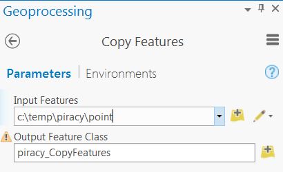
Insider "Pro" tip from Steve Lynch (Esri). Use the Copy Features GP tool in Pro and put in the complete coverage path including the geometry to import into a geodatabase and/or shapefile. Works like a charm! See the graphic below.
- Mark as New
- Bookmark
- Subscribe
- Mute
- Subscribe to RSS Feed
- Permalink
Robert, that's fantastic, so then, Pro can't view coverages in the interface -- but the geoprocessing environment can still see them. Joseph Kerski is specifically looking at .e00 files posted on websites, this means a Python script supported by Pro could run import71.exe and then do the import. The .e00 files are clear text so it should be straightforward for a python script to scan the first line for the e00 content and use that information to tell the script what to do next.
Wish I wasn't swamped right now, but seems to me it would great if the GP team could post a sample for us to use. It doesn't sound like that difficult of a script.
- « Previous
-
- 1
- 2
- Next »
- « Previous
-
- 1
- 2
- Next »