- Home
- :
- All Communities
- :
- Products
- :
- ArcGIS Pro
- :
- ArcGIS Pro Questions
- :
- Auto Populate Lat / Long Fields in ArcGIS Pro
- Subscribe to RSS Feed
- Mark Topic as New
- Mark Topic as Read
- Float this Topic for Current User
- Bookmark
- Subscribe
- Mute
- Printer Friendly Page
Auto Populate Lat / Long Fields in ArcGIS Pro
- Mark as New
- Bookmark
- Subscribe
- Mute
- Subscribe to RSS Feed
- Permalink
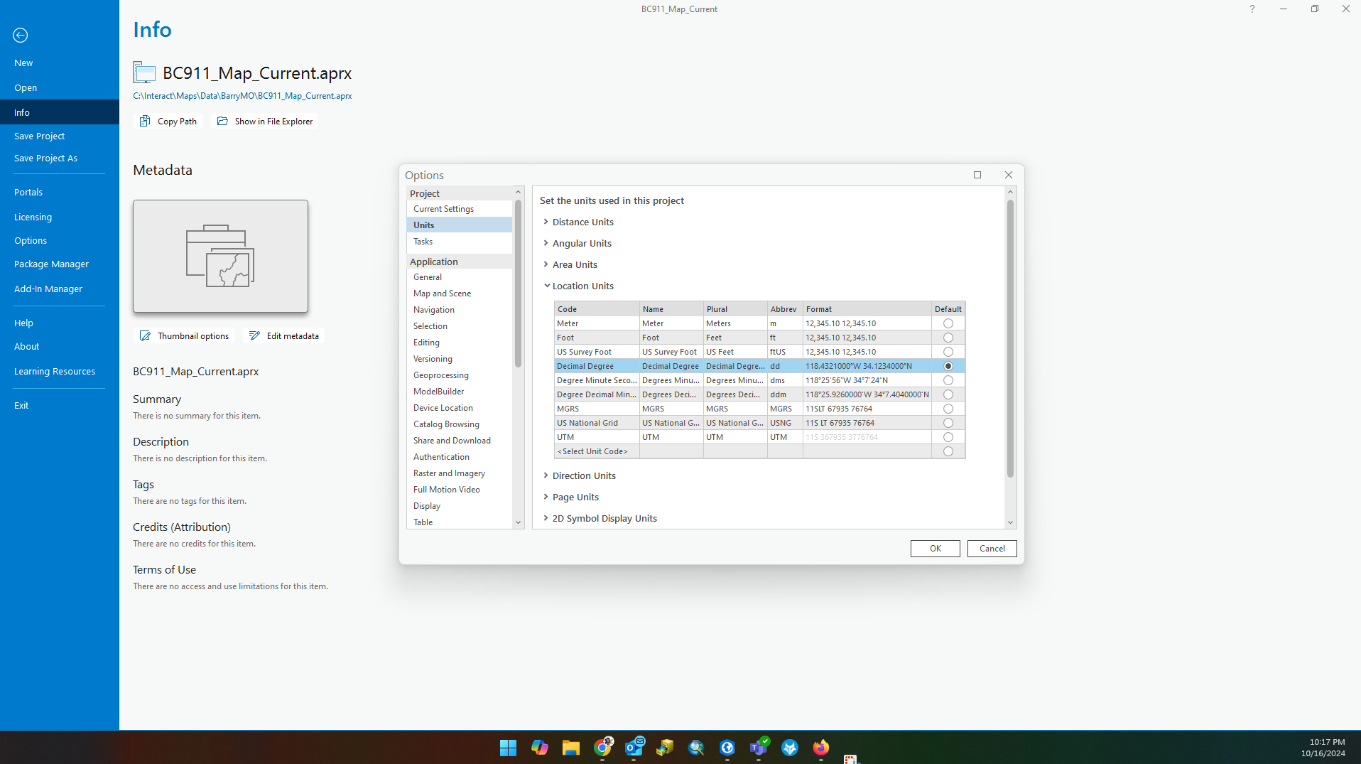
Is there a way to auto populate Lat / Long coordinates in decimal degrees in ArcGIS Pro? We have deployed ESRI's Address Data Management solution and use that to assign and maintain our address points and road centerlines. In the attribute rules, I have added one to try and populate the coordinates but it will not auto populate in the decimal degree format. The map project shows the decimal degree is set to default, the map itself uses the format when working on the map, it will let me manually get the decimal degree format, but it will not go to that format automatically. I have attached some pictures of what is going on.
- Mark as New
- Bookmark
- Subscribe
- Mute
- Subscribe to RSS Feed
- Permalink
Hello Cameron,
- Is there a way to "auto populate" Lat / Long coordinates in decimal degrees
I'm not certain I understand your question. From the attached pictures it appears that the table attributes "Latitude_Y, Longitude_X" ARE populated with coordinate pairs displayed in decimal degrees. i.e. 36.93051
- Mark as New
- Bookmark
- Subscribe
- Mute
- Subscribe to RSS Feed
- Permalink
Thank you for responding to the post! The Lat / Long fields are populated in decimal degrees because I went to calculate fields and was able to do it that way. If you look at picture 5, that is the way that the attribute rule is auto-populating the coordinates. They are only populating in decimal degree format when I manually do calculate fields.
- Mark as New
- Bookmark
- Subscribe
- Mute
- Subscribe to RSS Feed
- Permalink
Okay, Let's take a look at the table attribute "fields view" to better understand how the coordinates pairs are stored. i.e. Numeric, Direction, etc...

- Mark as New
- Bookmark
- Subscribe
- Mute
- Subscribe to RSS Feed
- Permalink
Interesting... A float data type is a single-precision 32-bit floating point number that can precisely store numbers that contain up to six digits only. For example, you could not store the number 515297.15 precisely in a float field. Is there a reason for NOT storing these numeric values with DOUBLE-PRECISION?
- Mark as New
- Bookmark
- Subscribe
- Mute
- Subscribe to RSS Feed
- Permalink
Our state service board has requested that Lat / Long fields have the Float data type.
- Mark as New
- Bookmark
- Subscribe
- Mute
- Subscribe to RSS Feed
- Permalink
Okay, fair enough. Have you tried changing the Fields View "Number Format" such that the value represents Decimal Degrees?
- Mark as New
- Bookmark
- Subscribe
- Mute
- Subscribe to RSS Feed
- Permalink
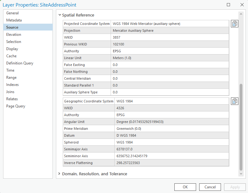
Again, if I understand your intentions correctly, you want X and Y coordinates in a table "display" as decimal degrees. Looking closer at your photo Arcpro5.png. I see numbers that appear to be coordinates that are expressed in Linear Units 4427846, -10456310(Meters or feet).
If the coordinates are indeed Lat/Lon, I'd expect to see DMS 40° 42' 46", or Radians 57.2958, or DD 40.7128°
Then in photo Arcpro2.png it appears to me (I could be wrong) you're using the field calculator to "convert" Linear values to degrees. This wouldn't be the recommended method. The Field Calculator does not handle the spatial reprojection.
I think it would be helpful to know the units of the X and Y coordinates. i.e. projected coordinate system or geographic system... Feet, meters, degrees?
You need to know the projected coordinate system (PCS) from which your data comes. This might be something like UTM (Universal Transverse Mercator), State Plane Coordinate System (SPCS), or another projection.