- Home
- :
- All Communities
- :
- Products
- :
- ArcGIS Pro
- :
- ArcGIS Pro Ideas
- :
- AUTO UPDATE EXCEL FILES TO LAYERS
- Subscribe to RSS Feed
- Mark as New
- Mark as Read
- Bookmark
- Follow this Idea
- Printer Friendly Page
- Mark as New
- Bookmark
- Subscribe
- Mute
- Subscribe to RSS Feed
- Permalink
IT WOULD BE CONVENIENT TO ALLOW LAYER FILES CREATED FROM EXCEL SPREADSHEETS TO ALLOW EDITING AS NEW DATA IS ADDED. ONE CAN ADD DATA POINTS TO THE ATTRIBUTE TABLE, BUT IT WILL NOT VISIBLE ON THE MAP. IT SHOULD BE AUTO ADDED TO THE MAP WITHOUT EXTRA STEPS.
Hi Feather,
Can you provide some more details on this idea?
How are you creating the layer from the Excel file? Are you creating an xy event layer or creating an xy feature class from the Excel data?
When you say that you can add data points to the attribute table, are you referring to the table from the layer in ArcMap/ArcGIS Pro? I don't think that layer is editable as an Event layer with the spreadsheet as the datasource. Or are you making edits in the Excel sheet and wanting to see them update dynamically in the map?
Please provide some more context so that we can fully understand what is being requested.
Thanks
Attached is a screen shot of the Earthquake Excel. layer file that I wish to edit each time I receive a new USGS earthquake report. The only way that I can edit the table is to create a point on the map with the edit tool and then it shows up in the table as zeros and then I have to put in the coordinates and the data.
It would far more convenient just to place the data into the table directly .
Perhaps you have a better solution.
Sometimes I need to just use a similar table from an Excel file for well spotting and subsequent mapping that I generally use just once.
However, working with an earthquake map over all of Texas over long periods of time the one time solution is an inconvenience.
Wm Feathergail Wilson PG 21, CPG 3566
B.A., B.S., M.A. University of Texas @ Austin
Strata Geological Services
13505 FM 462
Bandera (Tarpley), Texas 78003
Office: 830-562-3680
Cell 830-688-1624
Email: [email protected]
In other words, I could save a few steps by just editing the layer file created from the Excel file by not having to create a point and then re-editing the Excel Earthquake layer file.
Other wise I have to rename the Excel file and reload it up to the map.
Presently there 708 Earthquake points.
When I work a smaller area with just well spots I may have only about 20-30 points.
Geologists use these mapping techniques in many companies and settings with ArcGIS 10.6. I am an old consultant having worked for several major oil companies and my sons work for majors as geologists and use ArcGIS presently.
Wm Feathergail Wilson PG 21, CPG 3566
B.A., B.S., M.A. University of Texas @ Austin
Strata Geological Services
13505 FM 462
Bandera (Tarpley), Texas 78003
Office: 830-562-3680
Cell 830-688-1624
Email: [email protected]
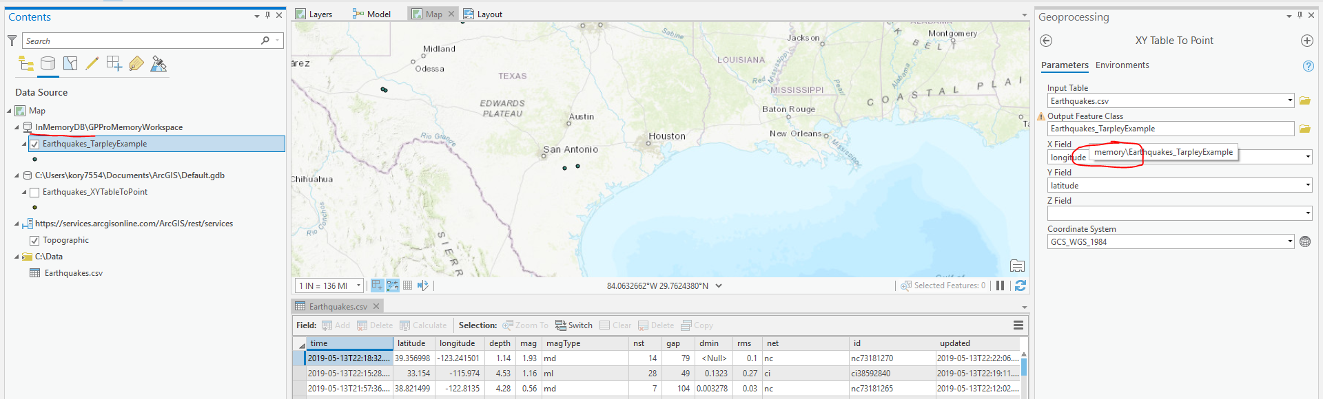
I didn't see any screenshot. I went to https://earthquake.usgs.gov/earthquakes/feed/v1.0/csv.php and grabbed some earthquake data for the last 7 days.
I create a feature class from it using XY Table to Point and get this:

Now, if I were maintaining a feature class of earthquakes that I wanted to add to, I could just create those points in memory, select only those that I want to add to my feature class, and Append to my feature class. That way you persist the points that you want in your long-term feature class (say for all of Texas) but aren't building up redundant data from the USGS Excel sheets.
Would something like that work? Wouldn't require any manual editing at all, and if it works, you could script it or build a model...
https://pro.arcgis.com/en/pro-app/help/analysis/geoprocessing/basics/the-in-memory-workspace.htm
https://pro.arcgis.com/en/pro-app/tool-reference/data-management/append.htm
It might work if I could copy my 708 rows and incorporate them into a feature class.
Many times with other Excel files I have the latitude of adding additional data fields.
I’m sorry you failed to receive the screen shot because it explains a lot. I will try it again now.
Wm Feathergail Wilson PG 21, CPG 3566
B.A., B.S., M.A. University of Texas @ Austin
Strata Geological Services
13505 FM 462
Bandera (Tarpley), Texas 78003
Office: 830-562-3680
Cell 830-688-1624
Email: [email protected]
Steps for editing earthquake points within a layer file originally created in Excel
1. Spot the reported Earthquake with the XY tool in Long/Lat on the map
2. Open Earthquake attribute file – scroll to base
3. Open Editor tool
4. Open Create feature tool and edit the Earthquake file – spot the spot
5. The spot shows up at the base of the attribute table with zeros – fill in the County-Long/Lat-Magnitude-Year
6. Save edits – close the table
My suggestion is to save steps 4-6 by incorporating them into the program to directly edit the attribute table originally created in Excel instead of the work-around described above.
I don’t know how to describe this without your watching how I do it.
Thanks
Feather
Wm Feathergail Wilson PG 21, CPG 3566
B.A., B.S., M.A. University of Texas @ Austin
Strata Geological Services
13505 FM 462
Bandera (Tarpley), Texas 78003
Office: 830-562-3680
Cell 830-688-1624
Email: [email protected]
I am creating an layer file from and Excel spreadsheet. I am editing new points by creating a feature point that shows up as zeros in the Excel spreadsheet layer file and changing the coordinates and other data and saving the attribute table. It would be convenient to have the program allow editing the Excel generated layer file directly.
Wm Feathergail Wilson PG 21, CPG 3566
B.A., B.S., M.A. University of Texas @ Austin
Strata Geological Services
13505 FM 462
Bandera (Tarpley), Texas 78003
Office: 830-562-3680
Cell 830-688-1624
Email: [email protected]
Note that Refresh Excel was added in ArcGIS Pro 2.9: https://pro.arcgis.com/en/pro-app/latest/tool-reference/data-management/refresh-excel.htm (that is the GP tool, but Refresh is also possible on an Excel workspace from the Catalog pane or view).
This allows users to make edits in the Excel sheet and refresh it in place in ArcGIS Pro without having to close and re-open the application.
If you are interested in editing the table directly in ArcGIS Pro and having that write to the Excel spreadsheet, see https://community.esri.com/t5/arcgis-pro-ideas/edit-csv-using-attribute-table/idi-p/1265721
There is also this related about having the attribute table refresh button trigger the Excel workspace refresh: https://community.esri.com/t5/arcgis-pro-ideas/refresh-excel-data-using-attribute-table-refresh/idi-...
You must be a registered user to add a comment. If you've already registered, sign in. Otherwise, register and sign in.