- Home
- :
- All Communities
- :
- Products
- :
- ArcGIS Online
- :
- ArcGIS Online Questions
- :
- Re: Issues creating a watershed
- Subscribe to RSS Feed
- Mark Topic as New
- Mark Topic as Read
- Float this Topic for Current User
- Bookmark
- Subscribe
- Mute
- Printer Friendly Page
Issues creating a watershed
- Mark as New
- Bookmark
- Subscribe
- Mute
- Subscribe to RSS Feed
- Permalink
Hey everyone,
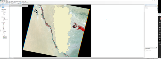
I am currently in the process of trying to create a watershed and DEM for a section of the Amu Darya river in Uzbekistan for my dissertation, I'm relatively new to ArcGIS.
I have followed all of the steps to create a watershed but the end result doesn't look right. The watershed is showing as extending all the way up into the Kyzylkoum desert. I've been trying all week to try different outlets of the river but I keep getting strange catchment areas or just no catchment at all?
My supervisor has also asked me to create a DEM for the whole of the Aral Sea but I have no idea on how I would get satellite imagery to cover the whole area, or how to even attempt to calculate the watershed for such a huge area. If anyone has any advice on these questions, I will be eternally grateful
Thanks,
Dave.
- Mark as New
- Bookmark
- Subscribe
- Mute
- Subscribe to RSS Feed
- Permalink
You may wish to use ArcGIS Pro for this work.
and SRTM (90m grid) may or may not be sufficient for what you are trying to accomplish in your hydrology model.
