- Home
- :
- All Communities
- :
- Products
- :
- ArcGIS Hub
- :
- ArcGIS Hub Questions
- :
- Re: Why did Hub get rid of map-based search?
- Subscribe to RSS Feed
- Mark Topic as New
- Mark Topic as Read
- Float this Topic for Current User
- Bookmark
- Subscribe
- Mute
- Printer Friendly Page
Why did Hub get rid of map-based search?
- Mark as New
- Bookmark
- Subscribe
- Mute
- Subscribe to RSS Feed
- Permalink
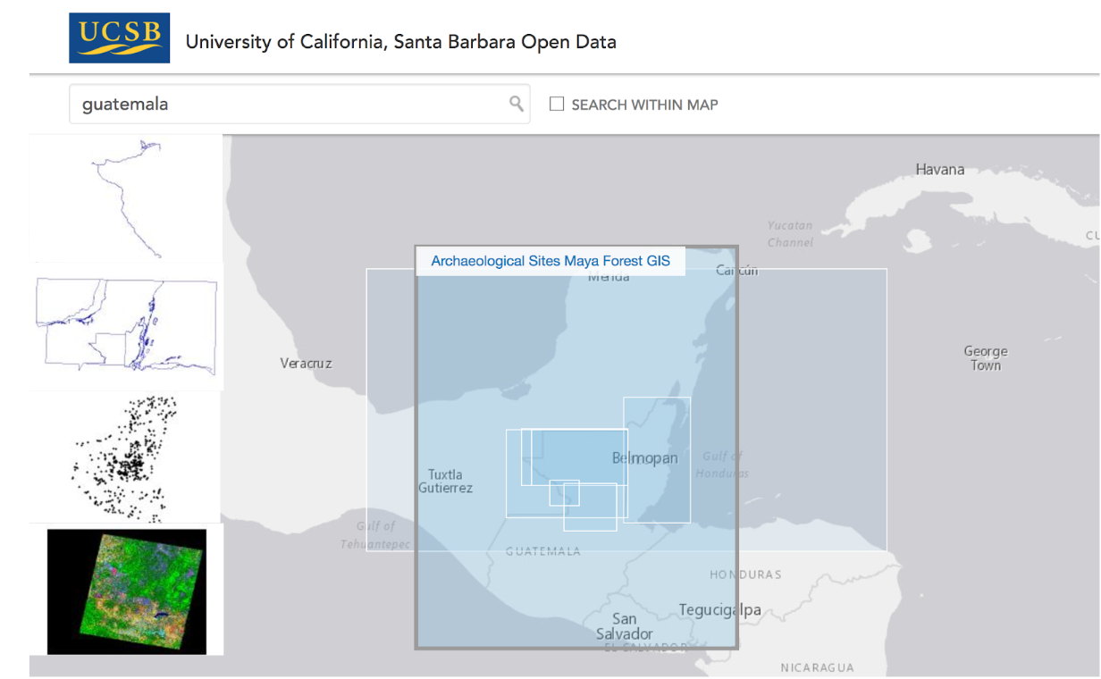
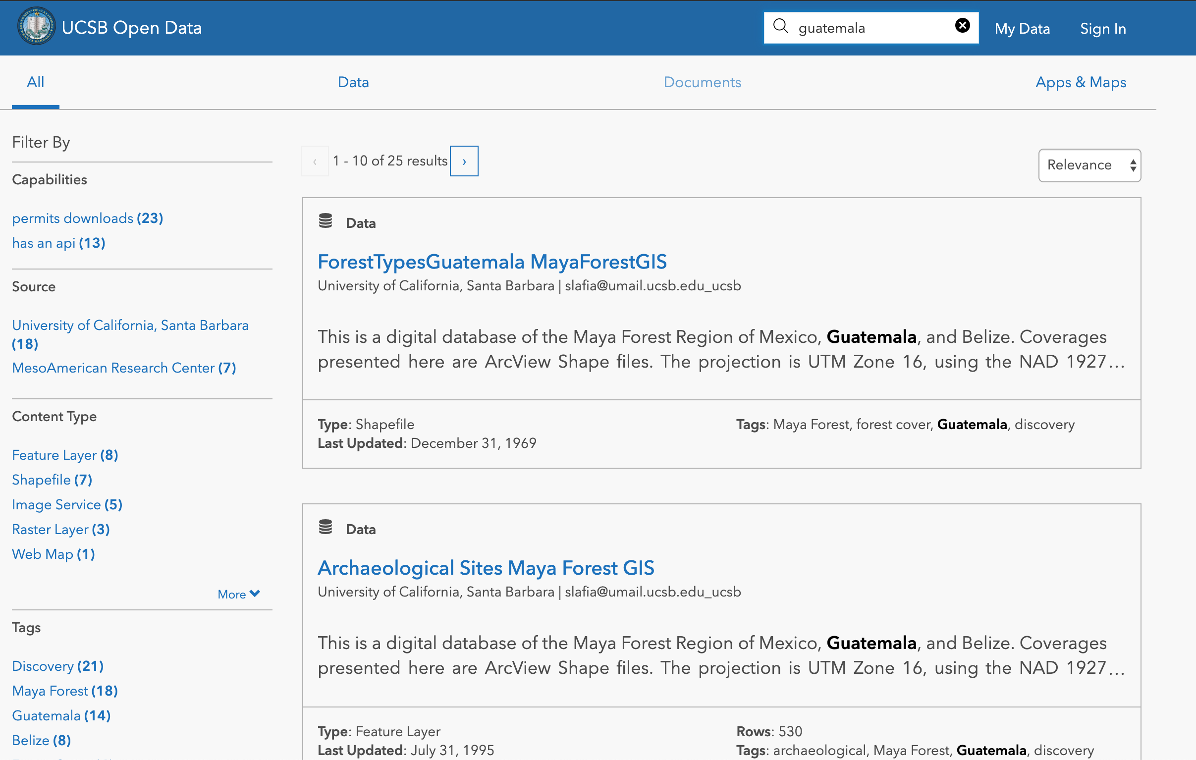
The best feature of Open Data was the map based search, which complemented the search facets. Getting rid of map-based search entirely in new Hub pages is not something my organization would like. Is there a way to revert an Open Data site to show the map search by default again? Thanks!
Previous map based search available in Open Data
Same search in Hub (no map-based search available)
- Mark as New
- Bookmark
- Subscribe
- Mute
- Subscribe to RSS Feed
- Permalink
Hi Sara,
Thanks for reaching out. Like you, we found the spatial search functionality in past iterations of Hub to be very useful. However, when our analytics did not bear this out and showed that very few people found the data they were looking for using the map we made the conscious decision to remove it from the default search experience. This wasn't taken lightly, particularly given how much we love maps here at Esri. After much internal discussion and further user testing we concluded that since the vast majority of our users weren't making use of the feature, it didn't make sense to dedicate so much screen real estate at the expense of other elements.
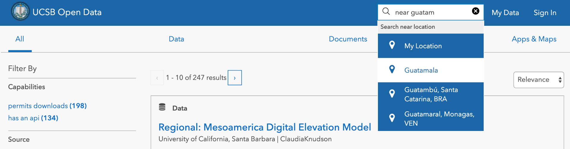
That said, spatial search is still supported using the near keyword in your search. Simply enter your query followed by near and then enter and/or select the location you want to search by. This way, the only time your end users see a map is when they explicitly ask for it. Here's how it works:
Enter near keyword:
Spatial extent of results displayed on map: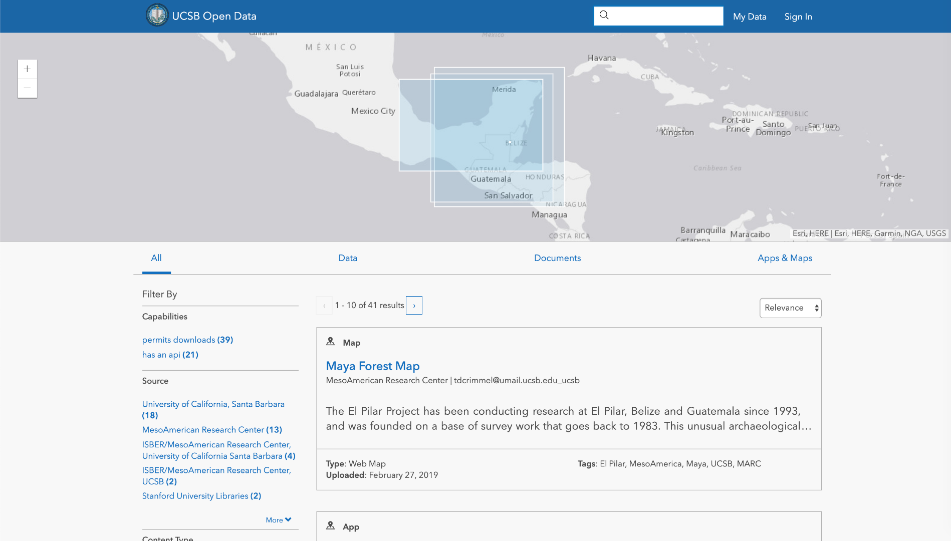
I hope that helps. We know how frustrating it can be to lose functionality you've come to rely on, but rest assured searching by location is still available for your site even if it's not as front and center as it used to be.
Best,
Patrick
- Mark as New
- Bookmark
- Subscribe
- Mute
- Subscribe to RSS Feed
- Permalink
Hi Patrick,
I appreciate your explanation; however, I am surprised and disappointed that Esri as a geospatial company chose to demote map-based search in favor of keyword based search (rather than try to improve the user experience within the map based search environment).
In my experience, these modes of search and interaction afford users very different experiences. The map based search allows users to gain an overview of the geographic extent of available data as well as glean useful summary level information, like which datasets overlap; integration by location cannot be replicated in keyword based search.
Moreover, the fact that users can type near as a substitute for location in their search only approximates one aspect of map based search. Is keyword search supported by a robust gazetteer on the backend? I cannot imagine that this is an improvement in many search scenarios, especially where users want to search using colloquial toponyms. I was able to search with near to produce a map, but it seems unlikely that most users will know how to do this.
Finally, I would like to add that this move to eliminate map based search is not in keeping with current trends in data curation (especially given that much of the data available through Hub is geospatial in nature). GeoBlacklight instances, like Stanford's EarthWorks, succeed in making data spatially discoverable; they also leverage search facets and semantic keyword based search in tandem with map based search (as they are not mutually exclusive).
I hope to stay involved as the Hub product continues to evolve and hope that Esri ultimately reconsiders its decision to move away from map based search.
Thank you for your time,
Sara Lafia
Geography PhD Student
University of California Santa Barbara
- Mark as New
- Bookmark
- Subscribe
- Mute
- Subscribe to RSS Feed
- Permalink
I understand the disappointment. As Graham notes, much of the focus of the Hub product (as opposed to Esri at large) is to connect organizations with the communities they serve to foster better engagement. This mission springs from the general open data ethos that finding and understanding an organization's data shouldn't require specialization of any kind. As a geospatial company, we tend to employ spatial approaches to everything we do, but for the Hub product in particular we have found that the map interface was at best superfluous to the experience of connecting organizations to their communities and at worst a barrier. Maps are incredibly powerful tools, but this power can be detrimental to novice users who just want to find the latest crime data for their neighborhood or see what events are happening near them.
In terms of the location search, we are keeping an eye on how the near keyword is used and will look into ways to make it more prominent if our users aren't finding it. Coming soon, we will be using maps much more prominently when searching for things like Events and we may add that interface to other content types in the future.
Additionally, I wanted to let you know that with our new semantic searching on the backend, colloquial toponyms can be supported. Right now we compare search terms against synonyms in order to calculate relevance, but slang terms will start to have an impact as well as search gets better. For example, searching for "Smokies" should return relevant content for Great Smoky Mountains National Park: https://hub.arcgis.com/search?q=smokies.
- Mark as New
- Bookmark
- Subscribe
- Mute
- Subscribe to RSS Feed
- Permalink
I'm not sure what the HUB is intended for but this sounds like trying to use Esri/Google/Apple Maps navigation to get somewhere without seeing the map thingy.
- Mark as New
- Bookmark
- Subscribe
- Mute
- Subscribe to RSS Feed
- Permalink
I understand your points, Sara & Bill. Understand that Hub is trying to connect non-GIS users to GIS data in a form factor that looks familiar to the everyday user. Hub sites "blend in" with organization websites and we spend a lot of energy to list the data, the site, and the attributes to major search engines.
So, in the context of a non-GIS user, think about the last time you did a search for something. What was it? How did you search for it? In 2019, for almost everything, users type in keywords into a search engine very quickly....even if the data they're looking for is spatial. IE, if i were to ask you how many counties there were in the United States, would you go to a map first or would you type that directly into a search engine? There are exception to this broad sweeping statement, absolutely (personally when I look for beach houses I use a map). But it's not the primary interface that most users are familiar with for finding things. More over, we still offer map visualization as my colleague Patrick mentions above.
This wasn't an easy choice for us and I was certainly skeptical when I heard the proposal internally.....but then I saw the numbers and the user testing and, well, we're hoping this improved layout will actually increase the amount of search traffic successes (people finding a result and clicking on it).
However, we have been wrong before and we will certainly listen for signals that we got this one wrong and adapt as necessary. Your feedback today is one of those signals and I really appreciate you taking the time to reach out.
If featuring a map of all of your data/extents is very important to your Site, you might want to consider using the Hub site's layout to feature such a map prominently.
- Mark as New
- Bookmark
- Subscribe
- Mute
- Subscribe to RSS Feed
- Permalink
I would also like to voice my deep disappointment in this decision. I respectfully ask ESRI to undo this. It actually blows me away you followed through in taking it away. Some decisions should not be based upon user metrics or analytics (as much as we live in a data driven world). I would suggest that ESRI's position as the world's largest GIS company and and "preacher" of the underlying philosophy of geography being the unifier of all data and that maps can change the world, that this should have guided this conversation. ESRI, I want to say gently that this was unequivocally the wrong decision.
Could we find some middle ground instead of throwing "out the baby with the bathwater". Maybe instead of getting rid of the map based search being so up front, make it more of a option instead. We just implemented a new Hub site that will act as our Open Data Portal and I was devastated to learn this news. I talked to the Community Engagement Folks at the Dev Summit asking how to do map based searches and they pointed me to this thread. We have some products that are gridded due to size (i.e. contours). If someone searches our site for "contours", the results are 400 items. You can try it yourself at data.cityofsalem.net. The user experience is horrible. The ability for a end user to filter results by a AOI or extents or a map is a critical need. Using the "near" keyword is not enough and certainly not prominent enough for end users (it also doesn't work).
- Mark as New
- Bookmark
- Subscribe
- Mute
- Subscribe to RSS Feed
- Permalink
Is HUB the revived esri Geography Network?
- Mark as New
- Bookmark
- Subscribe
- Mute
- Subscribe to RSS Feed
- Permalink
Similar to what Jacqui Martin just posted here in ArcGIS Ideas:
- Mark as New
- Bookmark
- Subscribe
- Mute
- Subscribe to RSS Feed
- Permalink
And @roberto_martinez here:
Ask esri about their previous Geography Network:
"With lots of changes over time to GIS and geographic information and the technologies used to serve them, the Geography Network has been replaced by better alternatives to publish and find data (like ArcGIS ). Much of the same exact content, and much more content that has been updated, can now be found and used in easier and better ways. So ESRI is planning to retire the Geography Network in late December 2009."
Using the Geography Network
The main feature of the Geography Network is invoked by clicking the “Geography Network Explorer” link on the home page. This launches a second window where the user can either browse through the available datasets or search by a variety of methods. There is an interactive map to narrow to search down geographically or you can type in the place you are interested in finding data and map services for. You can then search for specific type of data or have all data source for your selected region selected. The data is then viewable through a basic mapping applet. You can pan, zoom and print out maps from this window. In some cases the data is also available for immediate downloaded and is indicated by the icon.
Caitlin Dempsey Earl Nordstrand gis lounge Experience the History of ESRI and GIS