- Home
- :
- All Communities
- :
- Products
- :
- ArcGIS GeoEvent Server
- :
- ArcGIS GeoEvent Server Questions
- :
- Re: creating flat structure GeoEvent Definition fr...
- Subscribe to RSS Feed
- Mark Topic as New
- Mark Topic as Read
- Float this Topic for Current User
- Bookmark
- Subscribe
- Mute
- Printer Friendly Page
creating flat structure GeoEvent Definition from Verizon Networkfleet
- Mark as New
- Bookmark
- Subscribe
- Mute
- Subscribe to RSS Feed
- Permalink
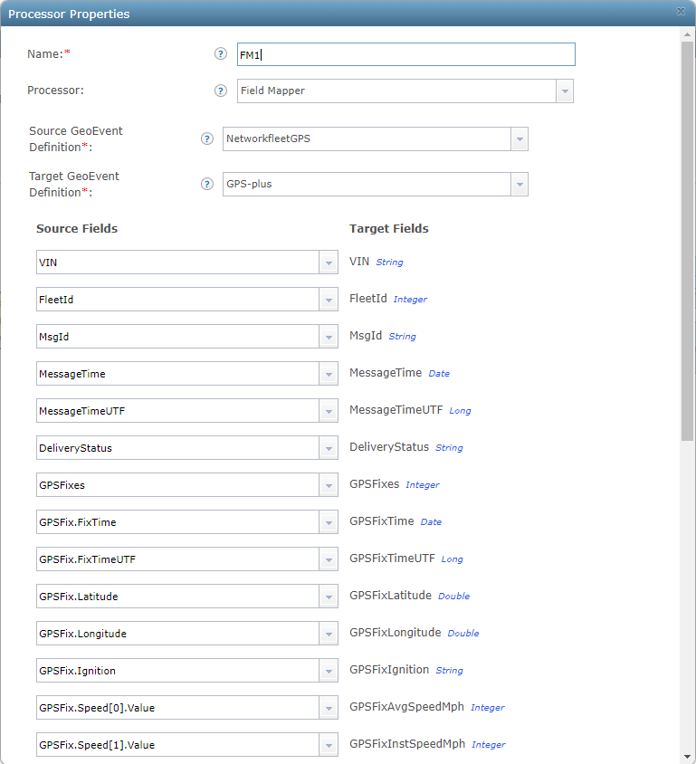
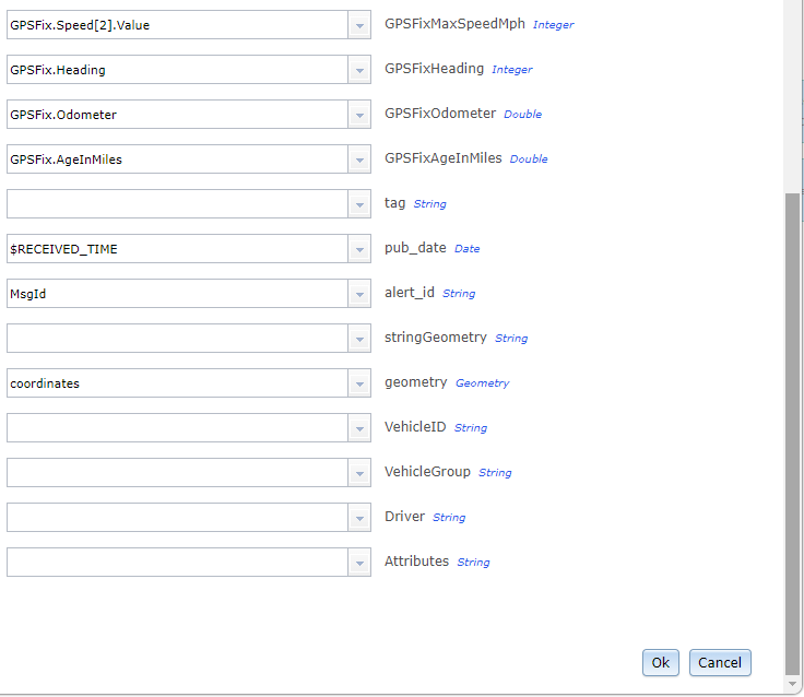
So I am completely new to GeoEvent Server. I am trying to understand how to map verizon's networkfleet message to a flat structure. The appendix page that comes with the instructions on how to install the connector is not very informative for a newbie like me. I need some more guidance. Is there anymore detailed info out there that shows how to do this?
I have all the definitions that get created when you add the adapter. I am confused about how you get this:
"GPSFix.Speed[0].Value"
"GPSFix.Speed[1].Value"
"GPSFix.Speed[2].Value"
I am not sure what the "value" part of this is, or the number in the brackets.
Also confused about the appropriate outputs to use. I have a feature service created. Just trying to figure out how I can get my feature service updated with the location of our vehicles. The end result I want is to have one point representing each vehicle in our fleet that shows their location every so often based off our contract with verizon. Don't need any elaborate set up. just a simple output showing locations with vehicle label.
Any help with where to find more documentation, or even an example of someones Geoevent service structure that they have created, would be greatly appreciated from a newbie such as myself
Thanks.
Solved! Go to Solution.
- Mark as New
- Bookmark
- Subscribe
- Mute
- Subscribe to RSS Feed
- Permalink
Nathan
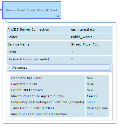
I had a quick question about the "delete old features" option under the advance section of the update feature output.
Does this actually delete your vehicle feature displayed on the map, or just the log info that gets sent to display the feature. Sorry if this sounds confusing. I guess I don't know how to really ask the question. My point that I am trying to get at is, what is the best practice or recommended setting to have so that our service doesn't start to get sluggish or bogged down. Thanks.
- Mark as New
- Bookmark
- Subscribe
- Mute
- Subscribe to RSS Feed
- Permalink
If you are using the Update Features output, then the "Delete Old" option will clear off vehicles that haven't moved in a while. Your service shouldn't get bloated with this setup: you will never have more records than you have trucks. However, if you use the "Add Feature" output, you can get a new feature record every time the GPS sends a signal. In that case, you will have a historic record, however it can turn into a huge dataset, so you may wish to limit the length of time you store them, which would be the value of "Delete Old."
- Mark as New
- Bookmark
- Subscribe
- Mute
- Subscribe to RSS Feed
- Permalink
Thanks Nate
- Mark as New
- Bookmark
- Subscribe
- Mute
- Subscribe to RSS Feed
- Permalink
Hello Folks
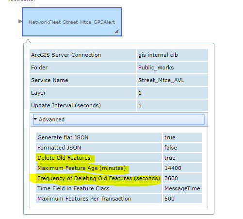
We have been using Verizon NetworkFleet inputs with GeoEvent for about the past 18 months. I'm happy to share what we've learned (mostly the hard way). We currently have public snow plow maps displaying live vehicle locations around the City. Here a few notes that we have discovered along the way:
- The Verizon GPS payload is really the only one we care about
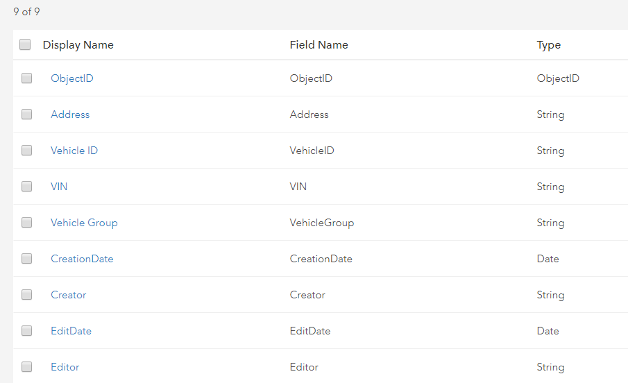
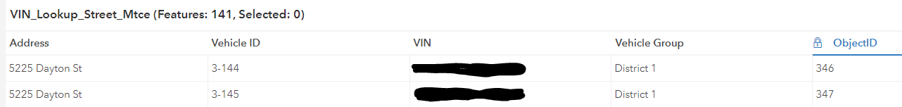
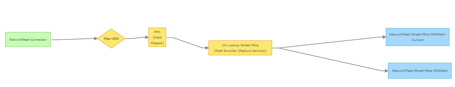
- For adding attributes like a vehicle id, vehicle group, or driver names, we found using the Field Enricher (feature service) is the most reliable way to go
- It is a good idea to come up with a data retention policy for AVL data because it can grow large fast and it will ultimately slow your feature service down if you don't truncate/archive it
Here is some information I recently shared with another user about we setup our GeoEvent services to add vehicle id's and other custom attributes:

- Mark as New
- Bookmark
- Subscribe
- Mute
- Subscribe to RSS Feed
- Permalink
Michael,
Thank you very much! We are learning the hard way here as well, although with responses like yours and Nathan's above, probably not has hard as yours!
I appreciate your willingness to take the time to share your experience.
One thing, the images you shared in the post above - those didn't come through, the links do not seem to show? The url is mail.google.com/mail.....
Would you be willing to send direct to me (espangenberg at lccountymt.gov)
Thank you again. I hope this has been as helpful to Erik Blake as it has been for me!
- Mark as New
- Bookmark
- Subscribe
- Mute
- Subscribe to RSS Feed
- Permalink
I think I fixed the images. Let me know if you still can't see them.
- Mark as New
- Bookmark
- Subscribe
- Mute
- Subscribe to RSS Feed
- Permalink
Fixed - thank you! This is very helpful!
- Mark as New
- Bookmark
- Subscribe
- Mute
- Subscribe to RSS Feed
- Permalink
Hey Michael, Good morning. So we just started experiencing our feature service really slowing down like you stated in your previous reply. I tried to compress our database and unregister our dataset to drop the delta tables. But it had grown so large that even trying to compress it and let it run over night didn't work, it just ran and did nothing. So I started from scratch built a new enterprise database and all that. And have now started to compress nightly or every other day. this seems to keep our feature service and the labeling performing pretty well. I guess my question fro you is what do you do to keep it from getting bogged down.
- Mark as New
- Bookmark
- Subscribe
- Mute
- Subscribe to RSS Feed
- Permalink
Hi Erik
We typically use two methods to control this data. 1) The Advanced settings of your Geoevent output enables you to Delete Old Features and set the age of those features to truncate. 2) We make regular backups of the feature classes, so we don't ever completely lose that old data.
A specific scenario might be snow plows. We typically get snow between November and March. We create daily backups of the snow plow AVL feature classes during that period by copying them into file gdb's and zipping those gdb's (might be overkill - could get away with less frequency) using Python scripts. Then we set the Advanced properties on our Geoevent output to only keep the data we need to use for public snow plow maps and internal analysis. We can always go back to an archived copy of the data if we need to use it.
Actually, since my earlier messages we are now writing all of our NetworkFleet data to hosted feature services on ArcGIS Online and it works well. We then publish this data as hosted feature views, where we can control which fields are visible and other filters. Hope this helps.