- Home
- :
- All Communities
- :
- Products
- :
- ArcGIS for Microsoft
- :
- ArcGIS for Microsoft Fabric
- :
- ArcGIS for Power BI
- :
- ArcGIS for Power BI Questions
- :
- How do you create a hosted feature layer for Power...
- Subscribe to RSS Feed
- Mark Topic as New
- Mark Topic as Read
- Float this Topic for Current User
- Bookmark
- Subscribe
- Mute
- Printer Friendly Page
How do you create a hosted feature layer for Power BI?
- Mark as New
- Bookmark
- Subscribe
- Mute
- Subscribe to RSS Feed
- Permalink
I have tried everything suggested by the tutorials. I have Shapefiles created by myself and 3rd party agencies, I've uploaded CSV, GEOJson, Json files and not one has prompted for this hosted feature layer checkbox that I'm supposed to click on to make it available (and PS. when they upload without an error that is).
I am at my wit's end trying to work out how to make this layer available to my #Power BI maps.
Solved! Go to Solution.
Accepted Solutions
- Mark as New
- Bookmark
- Subscribe
- Mute
- Subscribe to RSS Feed
- Permalink
Hey Steven -
Not sure I understand your question correctly - but I think you're asking "how do I set a feature layer so that it's not public."
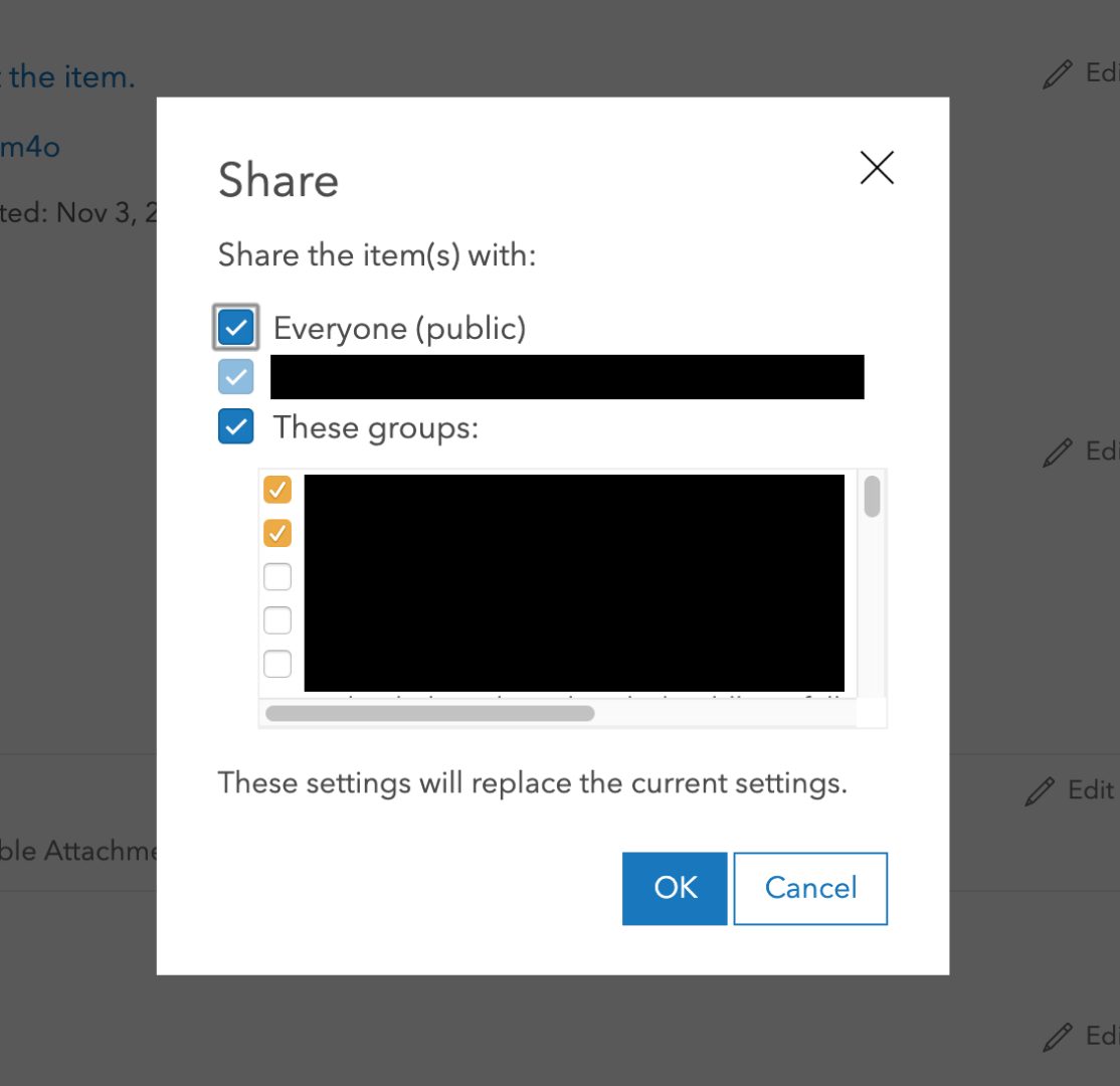
In ArcGIS Online, you would need to set the permissions for the layer to only be accessible by specific users rather than having the service set to "Public". If you didn't set those permissions when you initially published up the feature layer, click "Share" in ArcGIS Online and change the sharing settings there (uncheck "Everyone (public)" and only share it with the group containing the user that you actually want to be able to see it). It looks like this:
Since this is going outside of Maps for Power BI stuff, I'd recommend that you engage with support as well so that they can help walk through some of this stuff (particularly setting sharing from your original source) - I'm happy to still help with the Power BI side of things though!
Josh
- Mark as New
- Bookmark
- Subscribe
- Mute
- Subscribe to RSS Feed
- Permalink
Hey Steven - sorry to hear the process has been so frustrating. Can we start with what tools you have access to and are familiar with? Are you using ArcGIS Online, ArcMap, or ArcGIS Pro when trying to publish you hosted feature service? Once we identify a good starting point I'll try to help walk you through it.
- Mark as New
- Bookmark
- Subscribe
- Mute
- Subscribe to RSS Feed
- Permalink
I am trying to do the same thing with loading a feature layer to PowerBI. All I need is to link to the tabular information. Any help would be appreciated! Thanks
- Mark as New
- Bookmark
- Subscribe
- Mute
- Subscribe to RSS Feed
- Permalink
Hey Kimberley - I think you're asking for something slightly different. It sounds like you're wanting to add tabular data from the ArcGIS feature layer into Power BI as a table in the Power BI data model so you can then use Power BI visuals to display data from ArcGIS - is that right? If so, that's not something that is supported. At this time you can add ArcGIS feature layers as reference layers in the ArcGIS Maps for Power BI map visual for visualization and spatial interaction on the map (more here). You can view the information for each feature via popups on the map but we don't provide a direct connection to those underlying data.
- Mark as New
- Bookmark
- Subscribe
- Mute
- Subscribe to RSS Feed
- Permalink
Thank you for the information. Is there any talk of adding this capability?
Kim
- Mark as New
- Bookmark
- Subscribe
- Mute
- Subscribe to RSS Feed
- Permalink
There hasn't been any talk of adding this capability to the visual, as Power BI handles data connections through their data connectors in the 'Get Data' area of the product. Our map visual simply visualizes the data model you've set up.
To my knowledge there have been no talks of adding an ArcGIS data connector into Power BI, but it's an interesting thought. Might want to add it to the Power BI ideas site and see if it catches on...
- Mark as New
- Bookmark
- Subscribe
- Mute
- Subscribe to RSS Feed
- Permalink
It's been 4-5 months since I posted this question. I gave up and started using Map Box because it got closer to what I required. However, there's been an update for ArcGIS for Power BI with more boundary selection options, so I have re-subscribed and although this solves one issue, it's still not the complete solution I require.
What I want to do is include a point reference layer with a boundary layer... perhaps that's a suggestion for a future improvement.
However, my immediate requirement brings me back to making a custom reference layer... do you think I can find a simple answer on how to do this? I get that I may have to subscribe to a paid online membership but, do you think I can find a subscription that makes sense. Every option includes services I don't need. All I want to do is transfer my ESRI formatted shapefiles, share the file publicly (which I don't understand why it has to be public) and then access the file as a reference layer in Power BI.
So a couple of questions here, does a paid for online subscription actually allow me to share layers to Power BI and, is there a more realistic cost for this simple service?
- Mark as New
- Bookmark
- Subscribe
- Mute
- Subscribe to RSS Feed
- Permalink
Sorry, another idea for future upgrades is to allow the visual to be used in the embed and publish to web functions... after all, we use it to promote the use of your visual as a part of the solution.
- Mark as New
- Bookmark
- Subscribe
- Mute
- Subscribe to RSS Feed
- Permalink
An online subscription does allow for the creation of feature layers used in Power BI. Thank you to staff at ESRI Australia for clarifying and for the offer of a 21 day trial account. However, my first tests indicate issues such as place and point labels aren't coming through.
- Mark as New
- Bookmark
- Subscribe
- Mute
- Subscribe to RSS Feed
- Permalink
Hi Steven,
Sorry for the delayed reply. I wanted to touch on your question and address a few points. Not sure if I can give you a complete answer given the information above, but I can at least start:
What I want to do is include a point reference layer with a boundary layer...
Typically in ArcGIS Maps for Power BI, the points that you bring in would be based on the data that is coming from Power BI itself, and the boundary layer (polygons) would be a reference layer that you add in, as you would normally drive selection of points (and thus cross filter other visuals) by the reference layer's polygons. This work flow wouldn't work if your reference layer was constructed of points, since the selection would only be driven by those points from your data that were exactly coincident with the reference layer points.
Since this isn't making sense to me, there's a good chance here that I'm not understanding your use case. Would you mind walking me through how you would use the point layer as a reference layer? I'd like to understand and see if that's something we should explore in the product.
... does a paid for online subscription actually allow me to share layers to Power BI ...
Yes, if you have an ArcGIS Online subscription, you can author your own custom feature services with a single layer and then consume those feature services back in ArcGIS Maps for Power BI. As an additional point here...
... share the file publicly (which I don't understand why it has to be public) ...
The requirement to share your layer publicly is only the case if you do not have a private ArcGIS Online organization. As long as you're signed into your ArcGIS Online account in Maps for Power BI, your layers can be privately shared within your organization. Layers must be shared publicly if you aren't signed in since there is otherwise no way to reach those layers.
... another idea for future upgrades is to allow the visual to be used in the embed and publish to web functions.
We're currently exploring this, as we've had this request from a number of people.
... my first tests indicate issues such as place and point labels aren't coming through.
Feature services do need to be restricted to a single layer in order to be consumed in ArcGIS Maps for Power BI. If you want to share a cop[y of the service that you're working with (or a representative example), I'd be happy to take a look and see if there's some reason that your labels aren't showing up.
Thanks,
Josh