- Home
- :
- All Communities
- :
- Products
- :
- ArcGIS Field Maps
- :
- ArcGIS Field Maps Questions
- :
- Must sign into ArcGIS Online to download offline a...
- Subscribe to RSS Feed
- Mark Topic as New
- Mark Topic as Read
- Float this Topic for Current User
- Bookmark
- Subscribe
- Mute
- Printer Friendly Page
Must sign into ArcGIS Online to download offline areas from ArcGIS Enterprise
- Mark as New
- Bookmark
- Subscribe
- Mute
- Subscribe to RSS Feed
- Permalink
We've been trying to figure out why users must log into ArcGIS Online when downloading offline areas from a map hosted on ArcGIS Enterprise. The user is occasionally prompted to sign into ArcGIS Online after defining an offline area in the app and then starting the download. We are having to create accounts for user in both are on-prem ArcGIS Enterprise portal as well as ArcGIS Online portal.
- Mark as New
- Bookmark
- Subscribe
- Mute
- Subscribe to RSS Feed
- Permalink
Here's a short video demonstrating this:
https://www.screencast.com/t/abFBXa33hGa
- Mark as New
- Bookmark
- Subscribe
- Mute
- Subscribe to RSS Feed
- Permalink
I think it's because the base maps being used are AGOL base maps, and you would need to store login credentials with the corresponding base map item in your portal, or else the user will be prompted to also login to AGOL before the base map can be downloaded.
- Mark as New
- Bookmark
- Subscribe
- Mute
- Subscribe to RSS Feed
- Permalink
@Sean_Haile Thanks for responding! Interesting, I had thought that too since the basemap I was initially using was a combination of our vector tile basemap (stored in our ArcGIS Online org - shared with Everyone), and Esri's vector tile basemap. However, I removed the Esri vector tile package and am just using our vector tile package. However, our vector tile package is hosted on our AGOL portal and shared with Everyone. I wouldn't think you would need to login to AGOL to sync our vector tile package but will investigate in that direction - thanks!
- Mark as New
- Bookmark
- Subscribe
- Mute
- Subscribe to RSS Feed
- Permalink
- Mark as New
- Bookmark
- Subscribe
- Mute
- Subscribe to RSS Feed
- Permalink
From the 'Take Webmaps Offline' webpage for Enterprise, it says: The default Esri basemaps included in your portal are not enabled for offline use. You can take similar basemaps offline by adding an Esri basemap from ArcGIS Online to your web map.
When I followed those instructions I was able to store credentials with a basemap item.
- Mark as New
- Bookmark
- Subscribe
- Mute
- Subscribe to RSS Feed
- Permalink
I'm really struggling with this. I've got a web map in my Portal that I'd like to take offline. My users want to use the esri Topographic basemap. When they try to download the map to offline, it says they need to login to AGOL. They don't have AGOL logins.
We do have an organization AGOL site but these field workers don't have logins to that site nor will they get any due to budget constraints.
I've followed the above replies to this thread and am baffled about how to get this to work.
I've logged into my AGOL Org, found the esri basemap, copied the URL, gone over to our Portal, added a new item, put in that basemap URL, and checked the "store credentials" for the item but when it asks for the username and password, nothing I put in works. I have a built-in named user account in our AGOL org and that isn't working.
I feel like I'm missing something pretty big with the whole process but darned if I can figure it out. Any further advice would be very welcome. I'm struggling to understand why my Portal users can't download esri basemaps to their offline maps without all this hassle.
- Mark as New
- Bookmark
- Subscribe
- Mute
- Subscribe to RSS Feed
- Permalink
Hey Royce,
As I understand it a named user account must authenticate the basemap layers using their ARCGIS Online account in portal.
1) Navigate to the layer you want (World Topographic Map - Overview (arcgis.com).
2) Then copy the rest endpoint.
3) Log into your enterprise portal.
4) Go to content and add "new item"
5) paste the rest url and then use your arcgis online named username and password to authenticate on the next page.
Hope this works for you.
Cheers,
Joe
Joe
- Mark as New
- Bookmark
- Subscribe
- Mute
- Subscribe to RSS Feed
- Permalink
I have struggled all week to figure this out - I know your post is rather old at this point but thought I would share what I have struggled through so far.
Using an enterprise portal account complicates things tremendously. Basic procedure was in order to make a map work offline we had to install the "Field Maps" app in our portal. Then basically had to make a copy of an ERSI basemap from here Tiled Basemaps (arcgis.com) and host it on our portal. Then had to publish that out as a layer, open a new web map - call this layer a basemap as a starting point in a new map, then recreate an entire workflow (adding and symbolizing all the layers) to a project I had already made and had working (except offline).
Then I could not share anything yet (except you have to share that new basemap layer public - there's a special thing) and go into the Field Maps App and begin making all my offline areas. After that (when several attempts failed) and when the offline areas actually took and did not fail - I was able to share all the layers back to the group and it worked. Oh by the way - couldn't use 2 basemaps - so had to redo everything as a separate shared map just so folks could have imagery.
The entire process is ridiculous. I hope this helps someone like me understand its a several day process and not easy. As a frequent but not expert level GIS person, making a "simple data collection app" has devolved to a task we would rather just pay a company to make rather than try and get to work internally.
- Mark as New
- Bookmark
- Subscribe
- Mute
- Subscribe to RSS Feed
- Permalink
Hey Josh,
I am sorry you are having so many issues. It sounds like you were able to get this to work? You were able to create that for export basemaps that are authorized by a "named user".
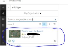
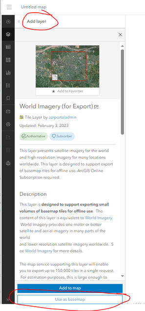
Couple of tips. If you have a project that already works, but you need a special basemap (or more than one basemap) you can go to the "add layers" and start to add it as a layer. When you click anywhere on the layer (but not the plus button). This will allow you to see the option to choose "Use as basemap". This will then replace your existing basemap. You can add other imagery in as layers in the map that will work for export as well as long as they are configured property.


