- Home
- :
- All Communities
- :
- Products
- :
- ArcGIS Field Maps
- :
- ArcGIS Field Maps Questions
- :
- ArcGIS Field Maps- Auto Orient Map- Issue
- Subscribe to RSS Feed
- Mark Topic as New
- Mark Topic as Read
- Float this Topic for Current User
- Bookmark
- Subscribe
- Mute
- Printer Friendly Page
ArcGIS Field Maps- Auto Orient Map- Issue
- Mark as New
- Bookmark
- Subscribe
- Mute
- Subscribe to RSS Feed
- Permalink
Hello ArcGIS Field Maps Team,
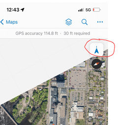
We currently have a project that requires the use of the auto orientation tool in the ArcGIS Field Maps map.
When collecting data (add point(+) > submit) we've noticed that the tool disengages and turns off.
We need this tool to persist since this project requires rapid data collection (helicopter aerial deer collection).
Is there any plan to resolve this issue?
Thank you,
Amanda Huber
Amanda Huber
- Mark as New
- Bookmark
- Subscribe
- Mute
- Subscribe to RSS Feed
- Permalink
I think that is the intended purpose of using the orientation tool, but the issue is that they would lose that azimuth as soon as they hit the collect button which would throw off their sense of direction on the map and lose the location they were aiming for which isn’t good when they’re trying to collect quickly.
I agree with your other suggestion. They could then just punch in estimated range information and use the gps metadata to get the azimuth and just offset the points.
- Mark as New
- Bookmark
- Subscribe
- Mute
- Subscribe to RSS Feed
- Permalink
Hi @RhettZufelt,
Yes, that is exactly why we need the auto orient tool!
We're currently looking into laser rangefinders as a solution for higher accuracy for "at a distance collection", but for right now this Field Maps auto orient functionality is the first issue.
- Mark as New
- Bookmark
- Subscribe
- Mute
- Subscribe to RSS Feed
- Permalink
Hi @Amanda__Huber ,
The behavior you describe is expected and was the same with Collector as well. When a collection is started auto-pan mode is turned off so as to not present a distraction while completing the form and to keep the feature being collected centered in the map view. I understand a change in this functionality might benefit your workflows greatly. I would suggest you log an Idea on the Community site and/or work with Support to get an enhancement logged.
Regards,
Colin
Colin
- Mark as New
- Bookmark
- Subscribe
- Mute
- Subscribe to RSS Feed
- Permalink
Hi FieldMaps Team,
I just wanted to circle back around on this. After recently working with QuickCapture, it appears this functionality is supported there! Maybe your team can collaborate with theirs to learn how they implemented this(?) just a thought!
Thanks,
Amanda Huber
- « Previous
-
- 1
- 2
- Next »
- « Previous
-
- 1
- 2
- Next »
