- Home
- :
- All Communities
- :
- Products
- :
- ArcGIS Enterprise
- :
- ArcGIS Enterprise Questions
- :
- Re: Publish StreetMap Premium locators without cop...
- Subscribe to RSS Feed
- Mark Topic as New
- Mark Topic as Read
- Float this Topic for Current User
- Bookmark
- Subscribe
- Mute
- Printer Friendly Page
Publish StreetMap Premium locators without copying the data to ArcGIS Server
- Mark as New
- Bookmark
- Subscribe
- Mute
- Subscribe to RSS Feed
- Permalink
Hi all,
I have ArcGIS Server 10.6 running on a Linux machine (Ubuntu 16.04 LTS). Our organisation has purchased the Esri StreetMap Premium SMP 2017 R3 data and the appropriate data license.
I've installed the data license in the server and copied a simple address locator for Guam (GUM_StreetAddress.loc, GUM_StreetAddress.loc.xml and GUM_StreetAddress.lox) to a local directory (/home/arcgis/gum_loc) in the machine where the server is running.
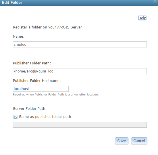
I've registered the directory as shown below: (and validated it)
Now, whenever I create a service definition file (without adding data into it) and publish a geocode service, the server does not recognise the locators in the registered directory.
It throws the following error:
ERROR 001487: Failed to update the published service with the server-side data location. Please see the server's log for more details. ERROR 001369: Failed to create the service. Failed to execute (Publish Service Definition). Failed.
The Server log showed the same message:
| SEVERE | May 30, 2018, 8:57:35 PM | Error executing tool. Publish Service Definition Job ID: jfb6284cd3f984415ba9088d783b80599 : ERROR 001487: Failed to update the published service with the server-side data location. Please see the server's log for more details. ERROR 001369: Failed to create the service. Failed to execute (Publish Service Definition). | System/PublishingTools.GPServer |
| SEVERE | May 30, 2018, 8:57:35 PM | Failed to create the service. | System/PublishingTools.GPServer |
| SEVERE | May 30, 2018, 8:57:35 PM | DoAfterSDExtraction failed. | System/PublishingTools.GPServer |
However, when I am publishing a MapServer from the same registered directory, the data is not copied to the server.
Question is: What is it I am doing wrong here that the Server does not recognise the data in the registered directory?
Thanks for your time!
Solved! Go to Solution.
Accepted Solutions
- Mark as New
- Bookmark
- Subscribe
- Mute
- Subscribe to RSS Feed
- Permalink
I had to register the publisher folder path separately, as the Server was running on a different machine.
@Jonathan thanks for the comment. Helped me locate the issue!
- Mark as New
- Bookmark
- Subscribe
- Mute
- Subscribe to RSS Feed
- Permalink
Did you register the data used for the map service using "localhost" as the Publisher Folder Hostname? Try with the fully qualified name of the Server and then the short name if the FQDN doesn't work.
- Mark as New
- Bookmark
- Subscribe
- Mute
- Subscribe to RSS Feed
- Permalink
You state the following but can you tell me how you went about creating your SD file?
"Now, whenever I create a service definition file (without adding data into it) and publish a geocode service, the server does not recognise the locators in the registered directory."
- Mark as New
- Bookmark
- Subscribe
- Mute
- Subscribe to RSS Feed
- Permalink
I created the service definition file from ArcMap's Share as a Service wizard.
The issue was that I did not specify the path to the locators in the publisher's machine.
Thank you for time!
- Mark as New
- Bookmark
- Subscribe
- Mute
- Subscribe to RSS Feed
- Permalink
I had to register the publisher folder path separately, as the Server was running on a different machine.
@Jonathan thanks for the comment. Helped me locate the issue!