- Home
- :
- All Communities
- :
- Products
- :
- ArcGIS Enterprise
- :
- ArcGIS Enterprise Questions
- :
- Feature templates ignored when publishing mxd
- Subscribe to RSS Feed
- Mark Topic as New
- Mark Topic as Read
- Float this Topic for Current User
- Bookmark
- Subscribe
- Mute
- Printer Friendly Page
Feature templates ignored when publishing mxd
- Mark as New
- Bookmark
- Subscribe
- Mute
- Subscribe to RSS Feed
- Permalink
Hi
I've come across this many times, but it's now becoming quite frustrating that when publishing an mxd as a feature service in ArcGIS Server, the feature templates included in the mxd are ignored and instead a default set of templates is generated based on the unique values used for symbology.
The help etc seems to suggest that templates created in the mxd are transferred to the feature service, but my experience is that this is not the case. For example, I have an mxd with a layer that is symbolised by unique values on a WO_STATUS field:

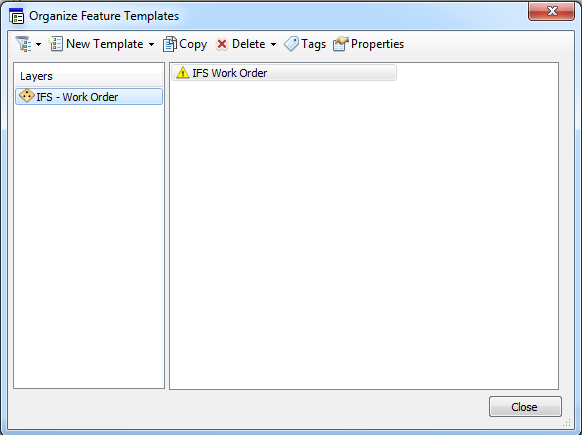
I have altered the feature templates for this layer to just have one template.
But when I publish as a feature service I get the following templates in the resulting feature service:
"types": [
{
"id": "ONROUTE",
"name": "In Progress",
"domains": {
"WO_STATUS": {"type": "inherited"}
},
"templates": [
{
"name": "In Progress",
"description": "",
"prototype": {
"attributes": {
"WO_NUMBER": null,
"WO_N_NUMBER": null,
"IFS_OBJECTID": null,
"WO_STATUS": "ONROUTE",
"WO_STATUS_DATE": null,
"WORK_TYPE": null,
"MAINT_ORG": null,
"DIRECTIVE": null,
"PRIORITY": null,
"DATE_CREATED": null,
"CREATED_USER": null,
"DATE_MODIFIED": null,
"MODIFIED_USER": null,
"IFSid": null
}
},
"drawingTool": "esriFeatureEditToolPoint"
}
]
},
{
"id": "UNDERPREPARATION",
"name": "Open",
"domains": {
"WO_STATUS": {"type": "inherited"}
},
"templates": [
{
"name": "Open",
"description": "",
"prototype": {
"attributes": {
"WO_NUMBER": null,
"WO_N_NUMBER": null,
"IFS_OBJECTID": null,
"WO_STATUS": "UNDERPREPARATION",
"WO_STATUS_DATE": null,
"WORK_TYPE": null,
"MAINT_ORG": null,
"DIRECTIVE": null,
"PRIORITY": null,
"DATE_CREATED": null,
"CREATED_USER": null,
"DATE_MODIFIED": null,
"MODIFIED_USER": null,
"IFSid": null
}
},
"drawingTool": "esriFeatureEditToolPoint"
}
]
},
{
"id": "FINISHED",
"name": "Closed",
"domains": {
"WO_STATUS": {"type": "inherited"}
},
"templates": [
{
"name": "Closed",
"description": "",
"prototype": {
"attributes": {
"WO_NUMBER": null,
"WO_N_NUMBER": null,
"IFS_OBJECTID": null,
"WO_STATUS": "FINISHED",
"WO_STATUS_DATE": null,
"WORK_TYPE": null,
"MAINT_ORG": null,
"DIRECTIVE": null,
"PRIORITY": null,
"DATE_CREATED": null,
"CREATED_USER": null,
"DATE_MODIFIED": null,
"MODIFIED_USER": null,
"IFSid": null
}
},
"drawingTool": "esriFeatureEditToolPoint"
}
]
},
{
"id": "REPORTED",
"name": "Closed",
"domains": {
"WO_STATUS": {"type": "inherited"}
},
"templates": [
{
"name": "Closed",
"description": "",
"prototype": {
"attributes": {
"WO_NUMBER": null,
"WO_N_NUMBER": null,
"IFS_OBJECTID": null,
"WO_STATUS": "REPORTED",
"WO_STATUS_DATE": null,
"WORK_TYPE": null,
"MAINT_ORG": null,
"DIRECTIVE": null,
"PRIORITY": null,
"DATE_CREATED": null,
"CREATED_USER": null,
"DATE_MODIFIED": null,
"MODIFIED_USER": null,
"IFSid": null
}
},
"drawingTool": "esriFeatureEditToolPoint"
}
]
},
{
"id": "FAULTREPORT",
"name": "Open",
"domains": {
"WO_STATUS": {"type": "inherited"}
},
"templates": [
{
"name": "Open",
"description": "",
"prototype": {
"attributes": {
"WO_NUMBER": null,
"WO_N_NUMBER": null,
"IFS_OBJECTID": null,
"WO_STATUS": "FAULTREPORT",
"WO_STATUS_DATE": null,
"WORK_TYPE": null,
"MAINT_ORG": null,
"DIRECTIVE": null,
"PRIORITY": null,
"DATE_CREATED": null,
"CREATED_USER": null,
"DATE_MODIFIED": null,
"MODIFIED_USER": null,
"IFSid": null
}
},
"drawingTool": "esriFeatureEditToolPoint"
}
]
},
{
"id": "CANCELED",
"name": "Closed",
"domains": {
"WO_STATUS": {"type": "inherited"}
},
"templates": [
{
"name": "Closed",
"description": "",
"prototype": {
"attributes": {
"WO_NUMBER": null,
"WO_N_NUMBER": null,
"IFS_OBJECTID": null,
"WO_STATUS": "CANCELED",
"WO_STATUS_DATE": null,
"WORK_TYPE": null,
"MAINT_ORG": null,
"DIRECTIVE": null,
"PRIORITY": null,
"DATE_CREATED": null,
"CREATED_USER": null,
"DATE_MODIFIED": null,
"MODIFIED_USER": null,
"IFSid": null
}
},
"drawingTool": "esriFeatureEditToolPoint"
}
]
},
{
"id": "ASSIGNED",
"name": "In Progress",
"domains": {
"WO_STATUS": {"type": "inherited"}
},
"templates": [
{
"name": "In Progress",
"description": "",
"prototype": {
"attributes": {
"WO_NUMBER": null,
"WO_N_NUMBER": null,
"IFS_OBJECTID": null,
"WO_STATUS": "ASSIGNED",
"WO_STATUS_DATE": null,
"WORK_TYPE": null,
"MAINT_ORG": null,
"DIRECTIVE": null,
"PRIORITY": null,
"DATE_CREATED": null,
"CREATED_USER": null,
"DATE_MODIFIED": null,
"MODIFIED_USER": null,
"IFSid": null
}
},
"drawingTool": "esriFeatureEditToolPoint"
}
]
},
{
"id": "PREPARED",
"name": "Open",
"domains": {
"WO_STATUS": {"type": "inherited"}
},
"templates": [
{
"name": "Open",
"description": "",
"prototype": {
"attributes": {
"WO_NUMBER": null,
"WO_N_NUMBER": null,
"IFS_OBJECTID": null,
"WO_STATUS": "PREPARED",
"WO_STATUS_DATE": null,
"WORK_TYPE": null,
"MAINT_ORG": null,
"DIRECTIVE": null,
"PRIORITY": null,
"DATE_CREATED": null,
"CREATED_USER": null,
"DATE_MODIFIED": null,
"MODIFIED_USER": null,
"IFSid": null
}
},
"drawingTool": "esriFeatureEditToolPoint"
}
]
},
{
"id": "WORKREQUEST",
"name": "Open",
"domains": {
"WO_STATUS": {"type": "inherited"}
},
"templates": [
{
"name": "Open",
"description": "",
"prototype": {
"attributes": {
"WO_NUMBER": null,
"WO_N_NUMBER": null,
"IFS_OBJECTID": null,
"WO_STATUS": "WORKREQUEST",
"WO_STATUS_DATE": null,
"WORK_TYPE": null,
"MAINT_ORG": null,
"DIRECTIVE": null,
"PRIORITY": null,
"DATE_CREATED": null,
"CREATED_USER": null,
"DATE_MODIFIED": null,
"MODIFIED_USER": null,
"IFSid": null
}
},
"drawingTool": "esriFeatureEditToolPoint"
}
]
},
{
"id": "null",
"name": "Open",
"domains": {
"WO_STATUS": {"type": "inherited"}
},
"templates": [
{
"name": "Open",
"description": "",
"prototype": {
"attributes": {
"WO_NUMBER": null,
"WO_N_NUMBER": null,
"IFS_OBJECTID": null,
"WO_STATUS": "null",
"WO_STATUS_DATE": null,
"WORK_TYPE": null,
"MAINT_ORG": null,
"DIRECTIVE": null,
"PRIORITY": null,
"DATE_CREATED": null,
"CREATED_USER": null,
"DATE_MODIFIED": null,
"MODIFIED_USER": null,
"IFSid": null
}
},
"drawingTool": "esriFeatureEditToolPoint"
}
]
},
{
"id": "UNKNOWN",
"name": "Open",
"domains": {
"WO_STATUS": {"type": "inherited"}
},
"templates": [
{
"name": "IFS Work Order",
"description": "",
"prototype": {
"attributes": {
"WO_STATUS": "UNKNOWN",
"WO_STATUS_DATE": null,
"WO_NUMBER": null,
"WO_N_NUMBER": null,
"IFS_OBJECTID": null,
"WORK_TYPE": null,
"MAINT_ORG": null,
"DIRECTIVE": null,
"PRIORITY": null,
"DATE_CREATED": null,
"CREATED_USER": null,
"DATE_MODIFIED": null,
"MODIFIED_USER": null,
"IFSid": null
}
},
"drawingTool": "esriFeatureEditToolPoint"
}
]
},
{
"id": "ACCEPTED",
"name": "In Progress",
"domains": {
"WO_STATUS": {"type": "inherited"}
},
"templates": [
{
"name": "In Progress",
"description": "",
"prototype": {
"attributes": {
"WO_NUMBER": null,
"WO_N_NUMBER": null,
"IFS_OBJECTID": null,
"WO_STATUS": "ACCEPTED",
"WO_STATUS_DATE": null,
"WORK_TYPE": null,
"MAINT_ORG": null,
"DIRECTIVE": null,
"PRIORITY": null,
"DATE_CREATED": null,
"CREATED_USER": null,
"DATE_MODIFIED": null,
"MODIFIED_USER": null,
"IFSid": null
}
},
"drawingTool": "esriFeatureEditToolPoint"
}
]
},
{
"id": "OBSERVED",
"name": "Open",
"domains": {
"WO_STATUS": {"type": "inherited"}
},
"templates": [
{
"name": "Open",
"description": "",
"prototype": {
"attributes": {
"WO_NUMBER": null,
"WO_N_NUMBER": null,
"IFS_OBJECTID": null,
"WO_STATUS": "OBSERVED",
"WO_STATUS_DATE": null,
"WORK_TYPE": null,
"MAINT_ORG": null,
"DIRECTIVE": null,
"PRIORITY": null,
"DATE_CREATED": null,
"CREATED_USER": null,
"DATE_MODIFIED": null,
"MODIFIED_USER": null,
"IFSid": null
}
},
"drawingTool": "esriFeatureEditToolPoint"
}
]
},
{
"id": "RELEASED",
"name": "Open",
"domains": {
"WO_STATUS": {"type": "inherited"}
},
"templates": [
{
"name": "Open",
"description": "",
"prototype": {
"attributes": {
"WO_NUMBER": null,
"WO_N_NUMBER": null,
"IFS_OBJECTID": null,
"WO_STATUS": "RELEASED",
"WO_STATUS_DATE": null,
"WORK_TYPE": null,
"MAINT_ORG": null,
"DIRECTIVE": null,
"PRIORITY": null,
"DATE_CREATED": null,
"CREATED_USER": null,
"DATE_MODIFIED": null,
"MODIFIED_USER": null,
"IFSid": null
}
},
"drawingTool": "esriFeatureEditToolPoint"
}
]
},
{
"id": "WORKDONE",
"name": "Closed",
"domains": {
"WO_STATUS": {"type": "inherited"}
},
"templates": [
{
"name": "Closed",
"description": "",
"prototype": {
"attributes": {
"WO_NUMBER": null,
"WO_N_NUMBER": null,
"IFS_OBJECTID": null,
"WO_STATUS": "WORKDONE",
"WO_STATUS_DATE": null,
"WORK_TYPE": null,
"MAINT_ORG": null,
"DIRECTIVE": null,
"PRIORITY": null,
"DATE_CREATED": null,
"CREATED_USER": null,
"DATE_MODIFIED": null,
"MODIFIED_USER": null,
"IFSid": null
}
},
"drawingTool": "esriFeatureEditToolPoint"
}
]
},
{
"id": "STARTED",
"name": "In Progress",
"domains": {
"WO_STATUS": {"type": "inherited"}
},
"templates": [
{
"name": "In Progress",
"description": "",
"prototype": {
"attributes": {
"WO_NUMBER": null,
"WO_N_NUMBER": null,
"IFS_OBJECTID": null,
"WO_STATUS": "STARTED",
"WO_STATUS_DATE": null,
"WORK_TYPE": null,
"MAINT_ORG": null,
"DIRECTIVE": null,
"PRIORITY": null,
"DATE_CREATED": null,
"CREATED_USER": null,
"DATE_MODIFIED": null,
"MODIFIED_USER": null,
"IFSid": null
}
},
"drawingTool": "esriFeatureEditToolPoint"
}
]
}
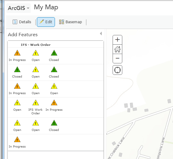
],This is clearly not based on the templates in the mxd, but on the unique values defined for symbology. This results in the following in something like the ArcGIS Online map viewer - which is not particularly user friendly.
For reference we are using:
ArcGIS Desktop 10.2.1
ArcGIS Server 10.2.1
If anyone has found a suitable workaround, I'd be glad to hear from you.
John
- Mark as New
- Bookmark
- Subscribe
- Mute
- Subscribe to RSS Feed
- Permalink
Hi John,
Did you ever get this sorted? I'm seeing the exact same thing - feature templates set in the MXD are ignored once published to ArcGIS Server and instead get created based on the unique value symbology.
Micah