- Home
- :
- All Communities
- :
- Products
- :
- ArcGIS Dashboards
- :
- ArcGIS Dashboards Questions
- :
- Category selector and charts just say "Loading..."...
- Subscribe to RSS Feed
- Mark Topic as New
- Mark Topic as Read
- Float this Topic for Current User
- Bookmark
- Subscribe
- Mute
- Printer Friendly Page
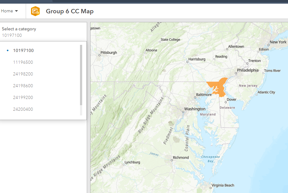
Category selector and charts just say "Loading..." when using OGC WFS layer
- Mark as New
- Bookmark
- Subscribe
- Mute
- Subscribe to RSS Feed
- Permalink
We are serving a number of layers from our Geoserver and using them in dashboards in ArcGIS Online.
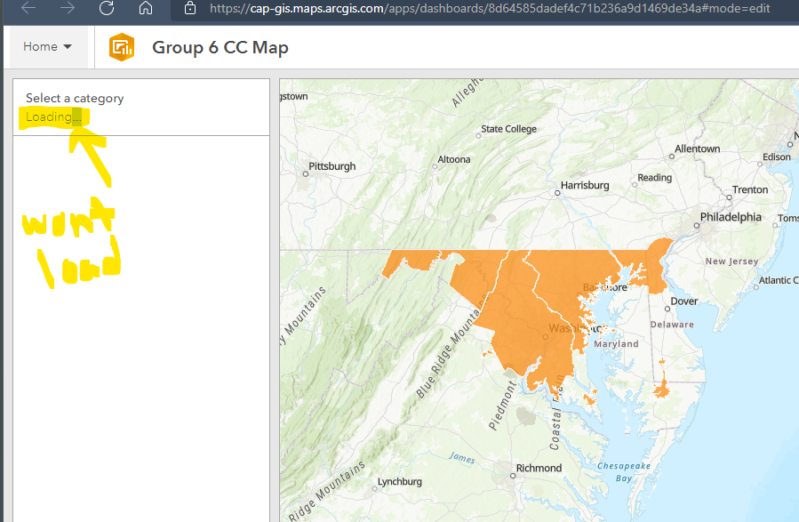
In edit mode, I can get the category selector and charts to display properly (THE FRIST VISIT) to the page. After I save and refresh, the categories wont load and the charrts all just say "Loading..." of the cirlce icon.
But if I go into the selector and change ANY setting. Color of tect for example, then the categories once again show up. But refresh and same problem. Same thing goes for the charts.
My dashboard viewers cannot see my dashboards correctly because they cant make an edit to get it to display. So they are totally stuck. This is very annoying.
Can someone please help?
- Mark as New
- Bookmark
- Subscribe
- Mute
- Subscribe to RSS Feed
- Permalink
Update: I created a new dashboard using data from the WFS link below and have the exact same problem. So I don't think the problem is with our Geoserver which is serving the WFS layers. I think this may be a bug in the arcgis dashboard; specifically the category selector and charts so far.
The data shows up on the map just fine. It's just the selector and charts where it only works the FIRST time you visit the page. THen after a refresh t just says Loading... But if you edit the selector or chart and change ANYTHING even font color or somethign benign, then it works again (once until the next refresh).
https://geodata.md.gov/imap/services/BusinessEconomy/MD_IncentiveZones/MapServer/WFSServer
- Mark as New
- Bookmark
- Subscribe
- Mute
- Subscribe to RSS Feed
- Permalink
Have you tried making the dashboard where the data is defaulted to Off visibility on the layers for better rendering? That may be a reason for your data not showing. Although it sounds more complicated than mere rendering it wouldn't hurt to see about checking how the data renders into your dashboard and what may be hanging up the connection or load times.
- Mark as New
- Bookmark
- Subscribe
- Mute
- Subscribe to RSS Feed
- Permalink
Good morning all,
@GIS_Fox thanks for the feedback, unfortunately that workaround didn't work. Working with support there doesn't seem to be any workaround.
ESRI has confirmed this to be a bug that came from the September release. Unfortunately it sounds like it may not get resolved until the Feb release. So frustrating. For reference there is a bug report # in case anyone else is having the same issue, you might be able to escalate and reference this bug#.
BUG-000143568
Thanks
- Mark as New
- Bookmark
- Subscribe
- Mute
- Subscribe to RSS Feed
- Permalink
Hi @ChChristian ,
Thanks for the update, looking forwards to February's release then. In the meantime did they offer any alternatives or short term fixes that already exist? I'd like to be able to avoid the same bug if at all possible, I'll earmark the bug number anyways though.
Best regards,