- Home
- :
- All Communities
- :
- Developers
- :
- ArcGIS API for Python
- :
- ArcGIS API for Python Questions
- :
- This GIS does not support spatial analysis.
- Subscribe to RSS Feed
- Mark Topic as New
- Mark Topic as Read
- Float this Topic for Current User
- Bookmark
- Subscribe
- Mute
- Printer Friendly Page
This GIS does not support spatial analysis.
- Mark as New
- Bookmark
- Subscribe
- Mute
- Subscribe to RSS Feed
- Permalink
Is this error more likely due to technical issues (that I'm trying to create a buffer in an unprojected/geographic crs, following the example in the california forest fires demo) or access (having failed to properly authenticate or have "credits" or do the equivalent of "check out an extension" or some such)?
gis = GIS(username='mine',password='mine')
What else would I need for the GIS to support spatial analysis?
- Mark as New
- Bookmark
- Subscribe
- Mute
- Subscribe to RSS Feed
- Permalink
Jill Kelly could you paste your code and the error message that is returned? Also to connect to a GIS, you need to specify the URL, either to ArcGIS Online or a Portal for ArcGIS as shown here: https://developers.arcgis.com/python/guide/working-with-different-authentication-schemes/#ArcGIS-Onl...
- Mark as New
- Bookmark
- Subscribe
- Mute
- Subscribe to RSS Feed
- Permalink
I am able to produce:

so to the best of my knowledge, I am authenticated. I have also been able to display maps.
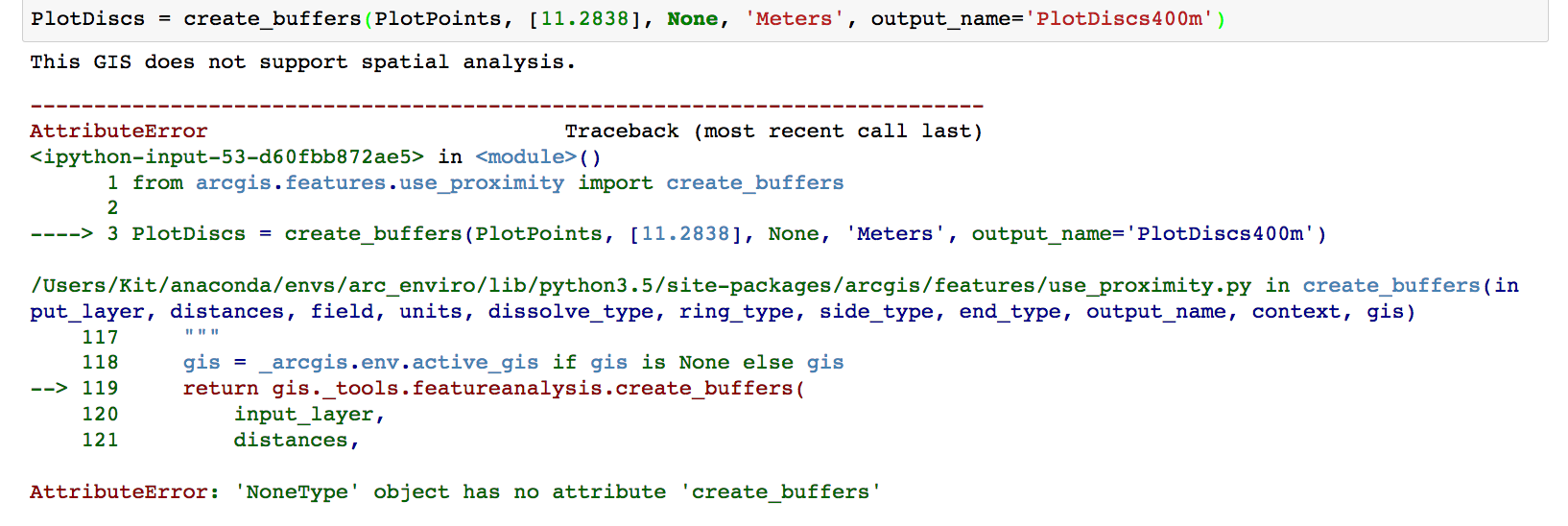
The specific line giving the no-spatial-analysis error is:
PlotDiscs = create_buffers(PlotPoints, [11.2838], None, 'Meters', output_name='PlotDiscs400m')
where PlotPoints is

PlotPoints also displays as it ought to on the map.
ps -- changing the url from the one they gave me when I signed up for a developer account to arcgis.com as your link instructs for an organization makes no difference. I am part of an organization, but I signed up as an individual, and we haven't yet connected me to them.
Full error message:
AMani-esristaff wrote:
Jill Kelly could you paste your code and the error message that is returned? Also to connect to a GIS, you need to specify the URL, either to ArcGIS Online or a Portal for ArcGIS as shown here: https://developers.arcgis.com/python/guide/working-with-different-authentication-schemes/#ArcGIS-Onl...
- Mark as New
- Bookmark
- Subscribe
- Mute
- Subscribe to RSS Feed
- Permalink
I'm currently completing a web-course in Esri Academy titled "Performing Analysis Using ArcGIS API for Python."
This course first has you import the GIS object, then it has you construct the GIS object to initialize a connection to https://www.arcgis.com (using your own user name and password for your ArcGIS organizational account).
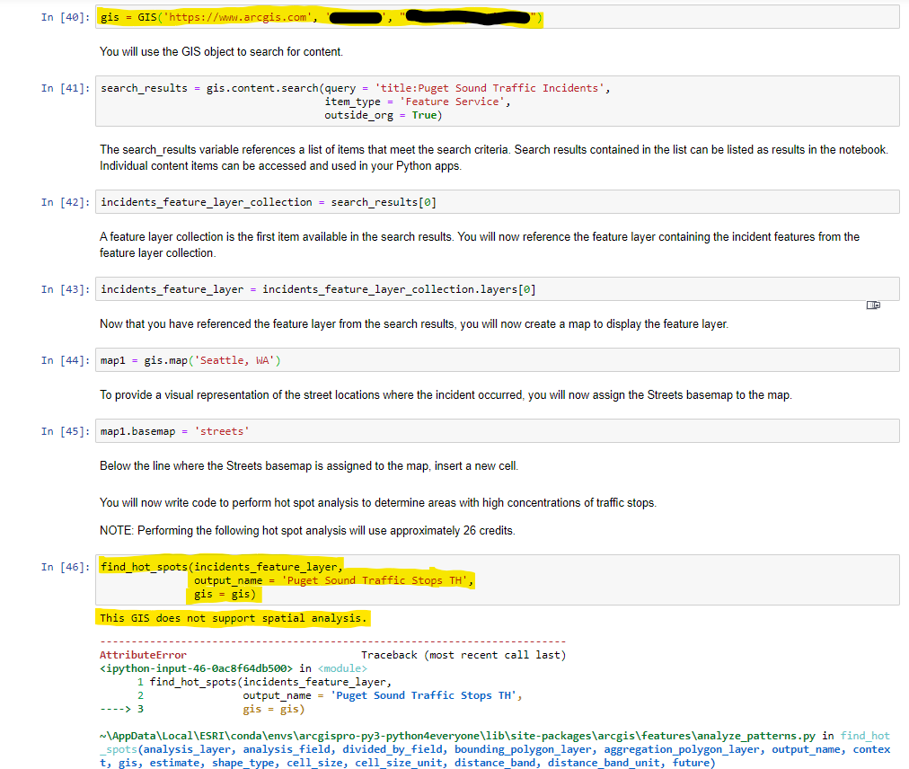
Later, the course instructs you to use find_hot_spots() to perform hot spot analysis and determine the area with high concentrations of traffic stops.
However, when I try to run find_hot_spots(), I receive the error "This GIS does not support spatial analysis."
I have the ArcGIS Pro for Personal Use license.
Notably, I can runs this line:
print("Logged in as " + str(gis.properties.user.username) + " to " + gis.properties.portalName)
Which, returns the following:
Logged in as [user_name] to ArcGIS Online
Many thanks to anyone who can point me in the right direction. Here is a screenshot of what I'm experiencing:
- Mark as New
- Bookmark
- Subscribe
- Mute
- Subscribe to RSS Feed
- Permalink
Hello, Ted!
Perhaps it may be too late, but I, too, am taking the same course and encountered the same error. The key is that you cannot perform spatial analysis with just an Esri public account. You will need to have an ArcGIS Online account as a result of being part of an organization or have an ArcGIS for Personal Use license, or have a free login from an Esri MOOC class giving you access to ArcGIS Online. Since I'm writing this during COVID-19, you should have other free training options from Esri that can also provide access. I hope this helps!
...pete...
- Mark as New
- Bookmark
- Subscribe
- Mute
- Subscribe to RSS Feed
- Permalink
Wondering if this issue has been solved by ESRI? I have exactly same problem and error that TedHellum above message.